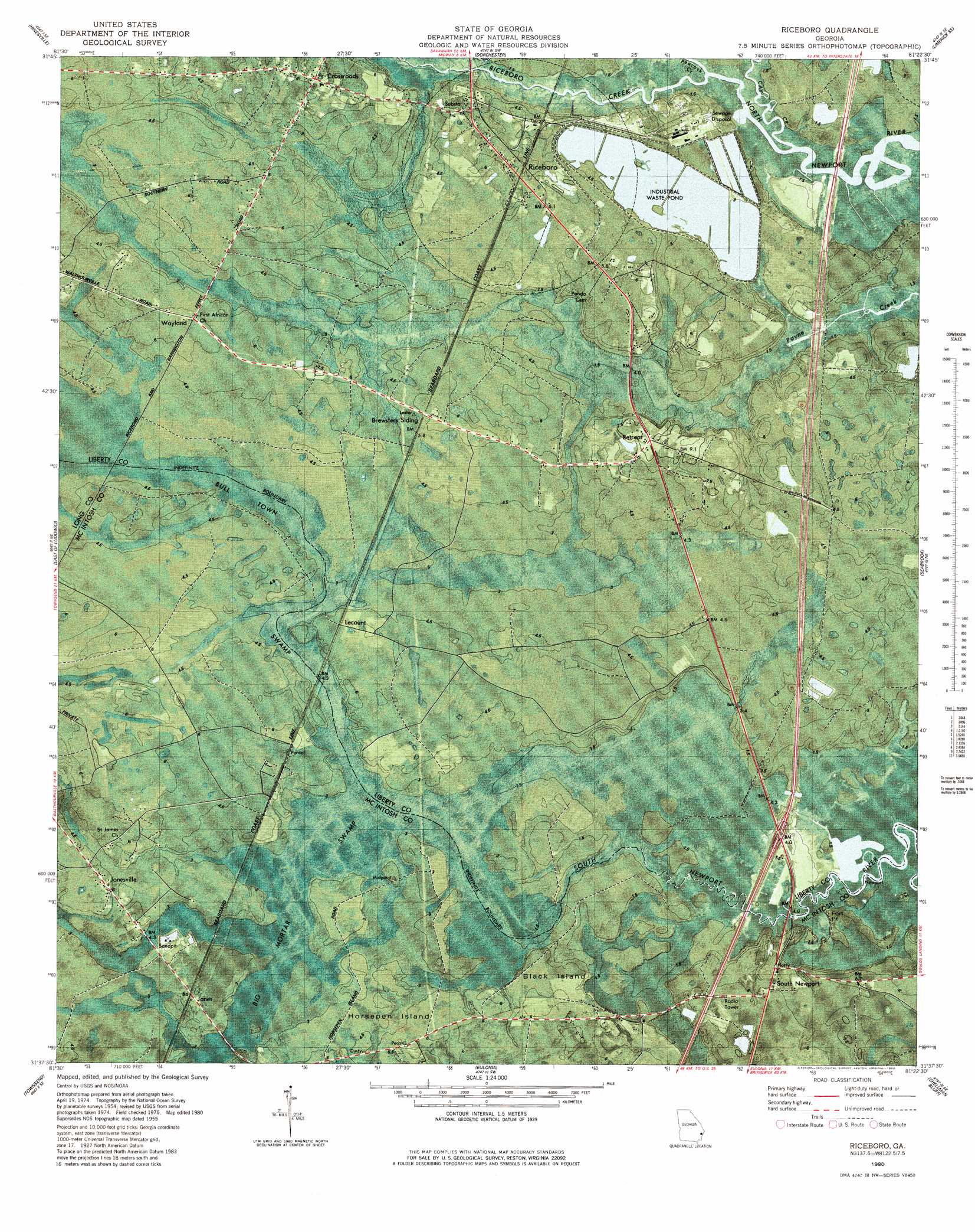
Riceboro Topo Map Georgia
To zoom in, hover over the map of Riceboro
USGS Topo Quad 31081f4 - 1:24,000 scale
| Topo Map Name: | Riceboro |
| USGS Topo Quad ID: | 31081f4 |
| Print Size: | ca. 21 1/4" wide x 27" high |
| Southeast Coordinates: | 31.625° N latitude / 81.375° W longitude |
| Map Center Coordinates: | 31.6875° N latitude / 81.4375° W longitude |
| U.S. State: | GA |
| Filename: | p31081f4.jpg |
| Download Map JPG Image: | Riceboro topo map 1:24,000 scale |
| Map Type: | Orthophoto |
| Topo Series: | 7.5´ |
| Map Scale: | 1:24,000 |
| Source of Map Images: | United States Geological Survey (USGS) |
| Alternate Map Versions: |
Riceboro GA 1955, updated 1959 Download PDF Buy paper map Riceboro GA 1955, updated 1977 Download PDF Buy paper map Riceboro GA 1980, updated 1980 Download PDF Buy paper map Riceboro GA 2011 Download PDF Buy paper map Riceboro GA 2014 Download PDF Buy paper map |
1:24,000 Topo Quads surrounding Riceboro
Taylors Creek |
Trinity |
Limerick Nw |
Richmond Hill |
Burroughs |
Walthourville |
Hinesville |
Dorchester |
Limerick Se |
Oak Level |
Ludowici |
East Of Ludowici |
Riceboro |
Seabrook |
Saint Catherines Sound |
Bug Island |
Townsend |
Eulonia |
Shellman Bluff |
Sapelo Sound |
Everett |
Cox |
Ridgeville |
Doboy Sound |
Cabretta Inlet |
> Back to 31081e1 at 1:100,000 scale
> Back to 31080a1 at 1:250,000 scale
> Back to U.S. Topo Maps home
Riceboro topo map: Gazetteer
Riceboro: Capes
Fort Point elevation 1m 3′Riceboro: Crossings
Exit 12 elevation 7m 22′Riceboro: Islands
Black Island elevation 5m 16′Horsepen Island elevation 4m 13′
Riceboro: Populated Places
Crossroads elevation 5m 16′Jones elevation 4m 13′
Lecount elevation 5m 16′
Retreat elevation 7m 22′
Riceboro elevation 5m 16′
South Newport elevation 5m 16′
Riceboro: Streams
Cay Creek elevation 1m 3′Peacock Creek elevation 1m 3′
Riceboro Creek elevation 1m 3′
Riceboro: Swamps
Big Mortar Swamp elevation 2m 6′Riceboro digital topo map on disk
Buy this Riceboro topo map showing relief, roads, GPS coordinates and other geographical features, as a high-resolution digital map file on DVD: