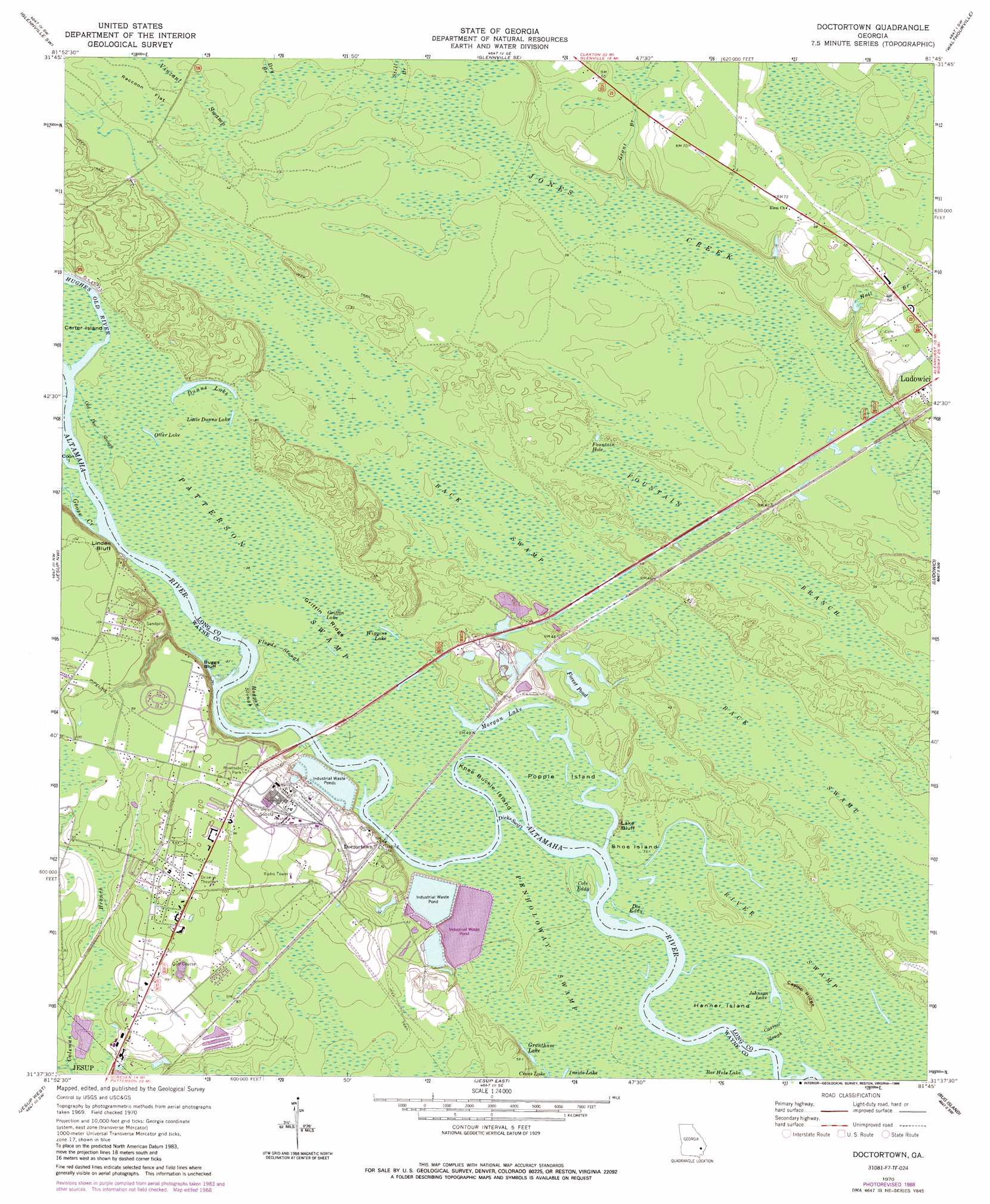
Doctortown Topo Map Georgia
To zoom in, hover over the map of Doctortown
USGS Topo Quad 31081f7 - 1:24,000 scale
| Topo Map Name: | Doctortown |
| USGS Topo Quad ID: | 31081f7 |
| Print Size: | ca. 21 1/4" wide x 27" high |
| Southeast Coordinates: | 31.625° N latitude / 81.75° W longitude |
| Map Center Coordinates: | 31.6875° N latitude / 81.8125° W longitude |
| U.S. State: | GA |
| Filename: | o31081f7.jpg |
| Download Map JPG Image: | Doctortown topo map 1:24,000 scale |
| Map Type: | Topographic |
| Topo Series: | 7.5´ |
| Map Scale: | 1:24,000 |
| Source of Map Images: | United States Geological Survey (USGS) |
| Alternate Map Versions: |
Doctortown GA 1970, updated 1973 Download PDF Buy paper map Doctortown GA 1970, updated 1988 Download PDF Buy paper map Doctortown GA 1970, updated 1997 Download PDF Buy paper map Doctortown GA 2011 Download PDF Buy paper map Doctortown GA 2014 Download PDF Buy paper map |
1:24,000 Topo Quads surrounding Doctortown
Tison |
Glennville |
Glennville Ne |
Taylors Creek |
Trinity |
Altamaha Se |
Glennville Sw |
Glennville Se |
Walthourville |
Hinesville |
Odum |
Jesup Nw |
Doctortown |
Ludowici |
East Of Ludowici |
Ritch |
Jesup West |
Jesup East |
Bug Island |
Townsend |
Screven |
Mckinnon |
Manningtown |
Everett |
Cox |
> Back to 31081e1 at 1:100,000 scale
> Back to 31080a1 at 1:250,000 scale
> Back to U.S. Topo Maps home
Doctortown topo map: Gazetteer
Doctortown: Bays
Cole Eddy elevation 9m 29′Doe Eddy elevation 8m 26′
Doctortown: Bridges
J Alvin Leaphart Senior Memorial Bridge elevation 9m 29′Doctortown: Channels
Dicks Swift elevation 9m 29′Hogpen Slough elevation 10m 32′
Old Doc Slough elevation 12m 39′
Doctortown: Cliffs
Buggs Bluff elevation 29m 95′Lake Bluff elevation 15m 49′
Linden Bluff elevation 26m 85′
Doctortown: Dams
Rayonier Lake Dam elevation 13m 42′Rayonier Lake Dam North elevation 13m 42′
Rayonier Lake Dam South elevation 12m 39′
Doctortown: Flats
Raccoon Flat elevation 13m 42′Doctortown: Guts
Casino Slough elevation 9m 29′Doctortown: Islands
Coon Island elevation 12m 39′Hanner Island elevation 10m 32′
Knee Buckle Island elevation 9m 29′
Negro Island elevation 9m 29′
Popple Island elevation 9m 29′
Shoe Island elevation 9m 29′
Doctortown: Lakes
Bar Hole Lake elevation 9m 29′Cross Lake elevation 11m 36′
Dunns Lake elevation 12m 39′
Forest Pond elevation 9m 29′
Fountain Hole elevation 12m 39′
Grantham Lake elevation 9m 29′
Griffin Lake elevation 11m 36′
Johnson Lake elevation 9m 29′
Little Dunns Lake elevation 12m 39′
Morgan Lake elevation 10m 32′
Otter Lake elevation 12m 39′
Wiggins Lake elevation 11m 36′
Doctortown: Populated Places
Doctortown elevation 23m 75′Piney Grove Mobile Home Park elevation 29m 95′
Doctortown: Reservoirs
Rayonier Lake elevation 13m 42′Rayonier Lake North elevation 13m 42′
Rayonier Lake South elevation 12m 39′
Doctortown: Ridges
Casino Ridge elevation 14m 45′Griffin Ridge elevation 11m 36′
Doctortown: Streams
Dry Branch elevation 12m 39′Floyds Slough elevation 9m 29′
Goose Creek elevation 10m 32′
Grant Branch elevation 12m 39′
Hall Branch elevation 12m 39′
Hughes Old River elevation 10m 32′
Still Branch elevation 12m 39′
Doctortown: Swamps
Back Swamp elevation 9m 29′Patterson Swamp elevation 11m 36′
Doctortown digital topo map on disk
Buy this Doctortown topo map showing relief, roads, GPS coordinates and other geographical features, as a high-resolution digital map file on DVD: