Hinesville Topo Map Georgia
To zoom in, hover over the map of Hinesville
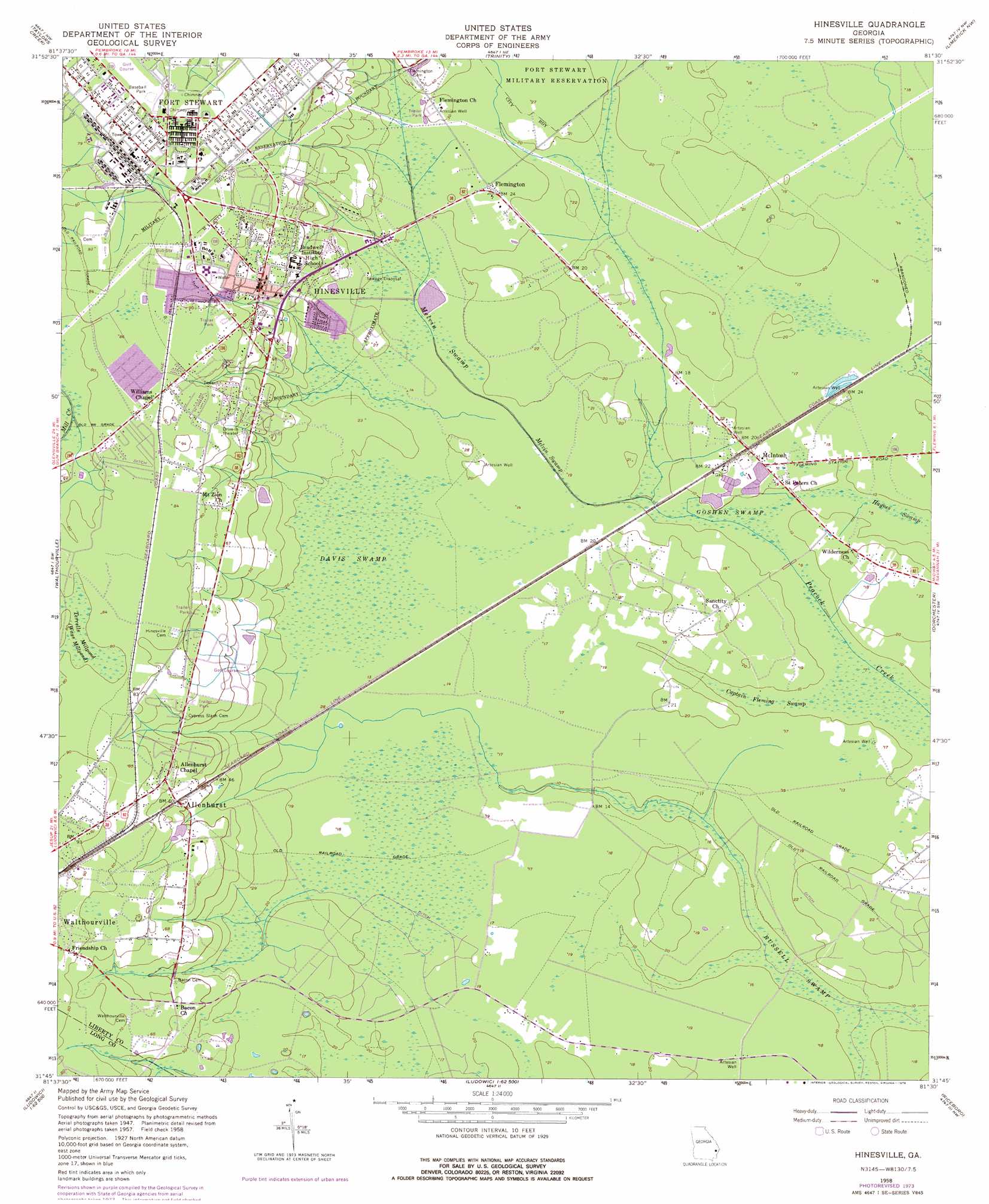
USGS Topo Quad 31081g5 - 1:24,000 scale
| Topo Map Name: | Hinesville |
| USGS Topo Quad ID: | 31081g5 |
| Print Size: | ca. 21 1/4" wide x 27" high |
| Southeast Coordinates: | 31.75° N latitude / 81.5° W longitude |
| Map Center Coordinates: | 31.8125° N latitude / 81.5625° W longitude |
| U.S. State: | GA |
| Filename: | o31081g5.jpg |
| Download Map JPG Image: | Hinesville topo map 1:24,000 scale |
| Map Type: | Topographic |
| Topo Series: | 7.5´ |
| Map Scale: | 1:24,000 |
| Source of Map Images: | United States Geological Survey (USGS) |
| Alternate Map Versions: |
Hinesville GA 1958, updated 1961 Download PDF Buy paper map Hinesville GA 1958, updated 1972 Download PDF Buy paper map Hinesville GA 1958, updated 1976 Download PDF Buy paper map Hinesville GA 2011 Download PDF Buy paper map Hinesville GA 2014 Download PDF Buy paper map |
1:24,000 Topo Quads surrounding Hinesville
Glissons Millpond |
Willie |
Letford |
Meldrim Sw |
Meldrim Se |
Glennville Ne |
Taylors Creek |
Trinity |
Limerick Nw |
Richmond Hill |
Glennville Se |
Walthourville |
Hinesville |
Dorchester |
Limerick Se |
Doctortown |
Ludowici |
East Of Ludowici |
Riceboro |
Seabrook |
Jesup East |
Bug Island |
Townsend |
Eulonia |
Shellman Bluff |
> Back to 31081e1 at 1:100,000 scale
> Back to 31080a1 at 1:250,000 scale
> Back to U.S. Topo Maps home
Hinesville topo map: Gazetteer
Hinesville: Airports
Liberty Memorial Hospital Heliport elevation 16m 52′Hinesville: Areas
Gills Island elevation 24m 78′Hinesville: Dams
Hinesville Oxidation Pond Dam elevation 4m 13′Hinesville: Populated Places
Allenhurst elevation 18m 59′Ashmore elevation 25m 82′
Bowen elevation 26m 85′
Bradwell Estates elevation 21m 68′
Cherokee Village elevation 20m 65′
Cinder Hill elevation 7m 22′
Country Lane Mobile Home Park elevation 17m 55′
Country Manor Mobile Home Park elevation 22m 72′
Deer Run Estates elevation 26m 85′
Deerwood Estates elevation 25m 82′
Doe Run Estates elevation 6m 19′
Doyles Mobile Home Park elevation 24m 78′
Eagle Creek Mobile Home Community elevation 11m 36′
Evergreen elevation 27m 88′
Flemington elevation 6m 19′
Fort Stewart elevation 5m 16′
Fraser Acres elevation 9m 29′
Garden Acres elevation 11m 36′
Garden Heights elevation 24m 78′
Harrison Heights elevation 20m 65′
Herbert Heights elevation 26m 85′
Hidden Pines elevation 17m 55′
Hinesville elevation 23m 75′
Lancaster Estates elevation 15m 49′
Live Oak elevation 24m 78′
Maple Subdivision elevation 18m 59′
Martin Woods elevation 15m 49′
Martins (historical) elevation 6m 19′
McIntosh elevation 5m 16′
Mill Creek elevation 24m 78′
Mosely Mobile Home Park elevation 23m 75′
Northwest Woods elevation 26m 85′
Olmstead elevation 25m 82′
Pineview elevation 27m 88′
Pinewood Estates elevation 24m 78′
Pointe South elevation 24m 78′
Sandy Run elevation 12m 39′
Tupelo Trail elevation 6m 19′
Way Subdivision elevation 16m 52′
Wildwood elevation 25m 82′
Woodwind South elevation 27m 88′
Hinesville: Post Offices
Allenhurst Post Office elevation 22m 72′Hinesville Post Office elevation 19m 62′
Hinesville: Reservoirs
Hinesville Oxidation Pond elevation 4m 13′Hinesville: Swamps
Captain Fleming Swamp elevation 3m 9′Davis Swamp elevation 5m 16′
Melvin Swamp elevation 3m 9′
Hinesville digital topo map on disk
Buy this Hinesville topo map showing relief, roads, GPS coordinates and other geographical features, as a high-resolution digital map file on DVD: