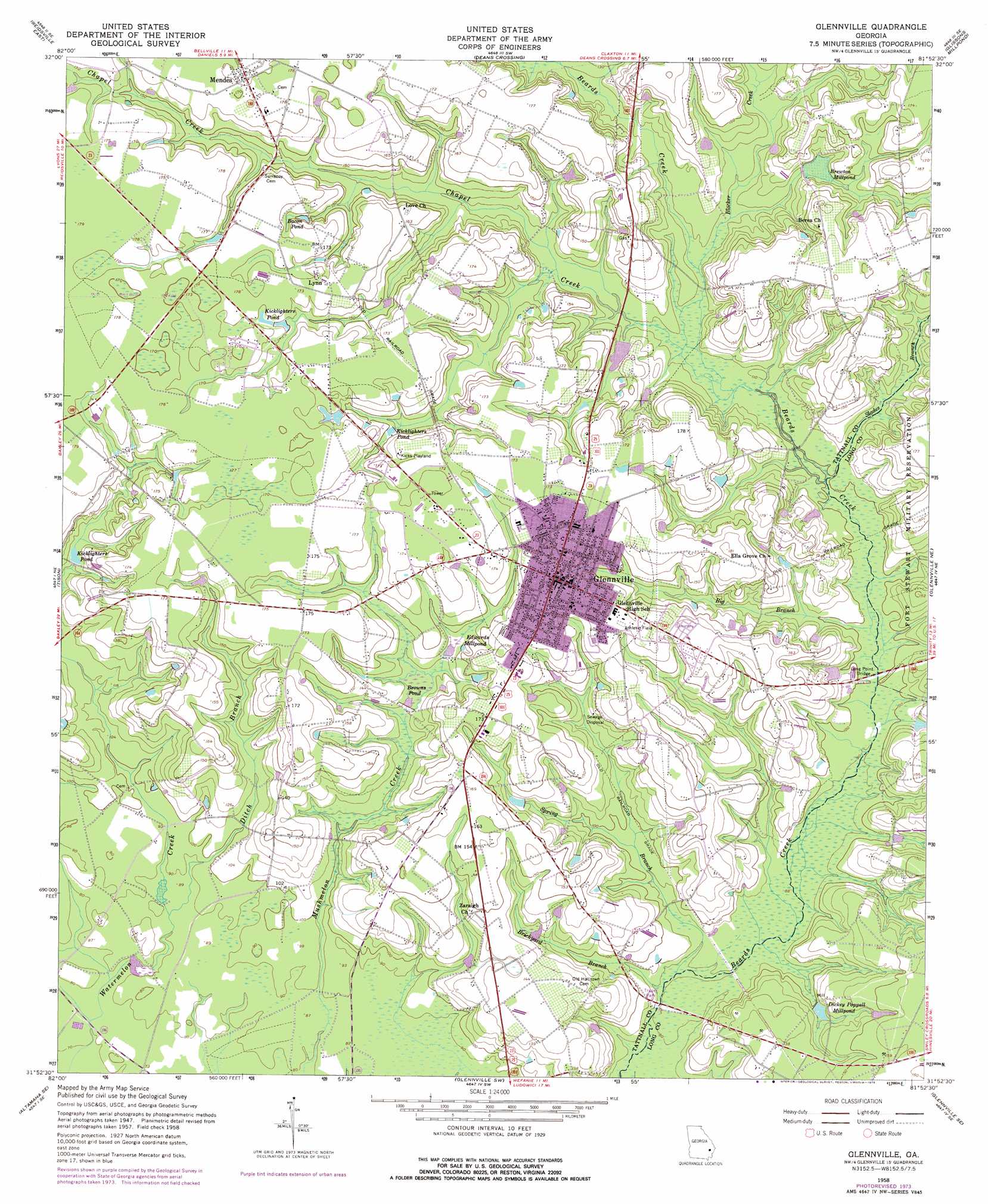
Glennville Topo Map Georgia
To zoom in, hover over the map of Glennville
USGS Topo Quad 31081h8 - 1:24,000 scale
| Topo Map Name: | Glennville |
| USGS Topo Quad ID: | 31081h8 |
| Print Size: | ca. 21 1/4" wide x 27" high |
| Southeast Coordinates: | 31.875° N latitude / 81.875° W longitude |
| Map Center Coordinates: | 31.9375° N latitude / 81.9375° W longitude |
| U.S. State: | GA |
| Filename: | o31081h8.jpg |
| Download Map JPG Image: | Glennville topo map 1:24,000 scale |
| Map Type: | Topographic |
| Topo Series: | 7.5´ |
| Map Scale: | 1:24,000 |
| Source of Map Images: | United States Geological Survey (USGS) |
| Alternate Map Versions: |
Glennville GA 1958, updated 1961 Download PDF Buy paper map Glennville GA 1958, updated 1966 Download PDF Buy paper map Glennville GA 1958, updated 1976 Download PDF Buy paper map Glennville GA 2011 Download PDF Buy paper map Glennville GA 2014 Download PDF Buy paper map |
1:24,000 Topo Quads surrounding Glennville
Ohoopee |
Collins |
Claxton |
Daisy |
Groveland |
Reidsville West |
Reidsville East |
Deans Crossing |
Glissons Millpond |
Willie |
Altamaha |
Tison |
Glennville |
Glennville Ne |
Taylors Creek |
Altamaha Sw |
Altamaha Se |
Glennville Sw |
Glennville Se |
Walthourville |
Surrency |
Odum |
Jesup Nw |
Doctortown |
Ludowici |
> Back to 31081e1 at 1:100,000 scale
> Back to 31080a1 at 1:250,000 scale
> Back to U.S. Topo Maps home
Glennville topo map: Gazetteer
Glennville: Bridges
Flat Ford Bridge elevation 30m 98′Halls Bridge elevation 23m 75′
Long Point Bridge elevation 30m 98′
Glennville: Crossings
Banards Ford elevation 27m 88′Flat Ford elevation 30m 98′
Jones Ford elevation 30m 98′
Long Point Ford elevation 30m 98′
Pigeon Ford elevation 33m 108′
Glennville: Dams
Strickland Pond Dam elevation 38m 124′Glennville: Lakes
Bacon Pond elevation 44m 144′Glennville: Parks
Kicks Playland elevation 52m 170′Glennville: Populated Places
Alton (historical) elevation 33m 108′Birdford (historical) elevation 52m 170′
Glennville elevation 52m 170′
Kicklighter (historical) elevation 52m 170′
Lynn elevation 53m 173′
Mendes elevation 55m 180′
Glennville: Post Offices
Glennville Post Office elevation 54m 177′Glennville: Reservoirs
Brewton Millpond elevation 35m 114′Browns Pond elevation 37m 121′
Edwards Millpond elevation 42m 137′
Kicklighter Pond (historical) elevation 36m 118′
Kicklighters Pond elevation 38m 124′
Kicklighters Pond elevation 44m 144′
Kicklighters Pond elevation 49m 160′
Maggies Lake elevation 33m 108′
Padgett Pond (historical) elevation 34m 111′
Stricklands Pond elevation 38m 124′
Glennville: Streams
Big Branch elevation 34m 111′Big Branch elevation 30m 98′
Blocker Creek elevation 33m 108′
Brickyard Branch elevation 23m 75′
Chapel Creek elevation 32m 104′
Ditch Branch elevation 23m 75′
Slades Branch elevation 30m 98′
Spring Branch elevation 23m 75′
Glennville digital topo map on disk
Buy this Glennville topo map showing relief, roads, GPS coordinates and other geographical features, as a high-resolution digital map file on DVD: