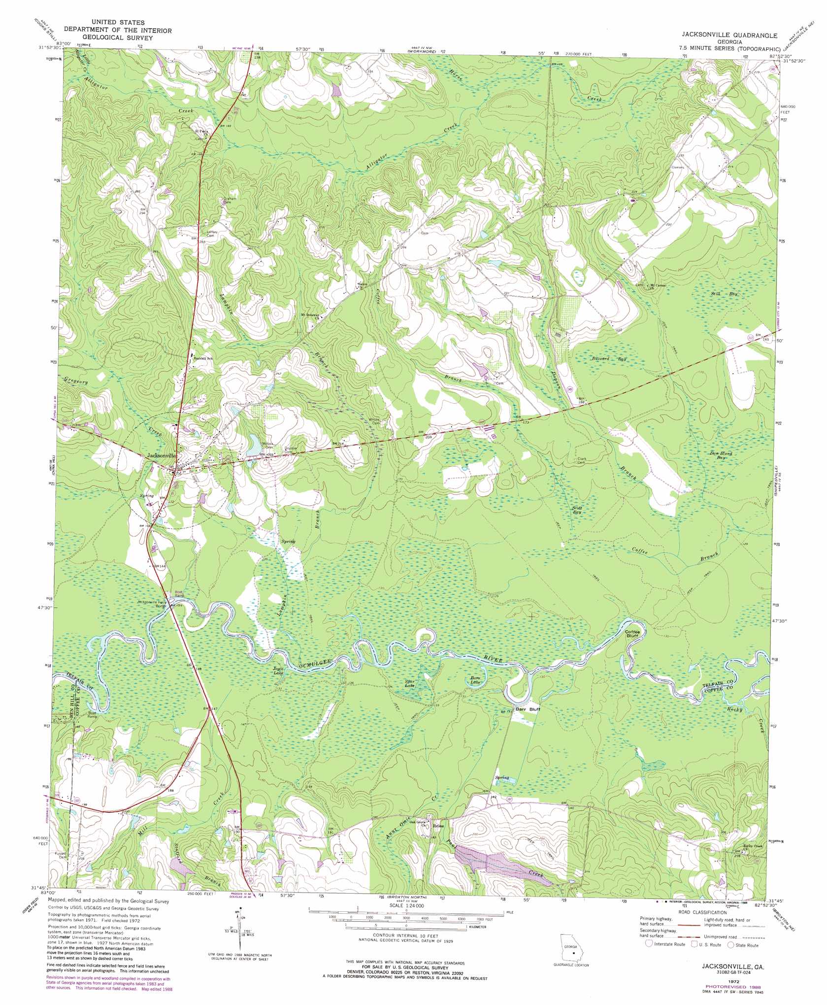
Jacksonville Topo Map Georgia
To zoom in, hover over the map of Jacksonville
USGS Topo Quad 31082g8 - 1:24,000 scale
| Topo Map Name: | Jacksonville |
| USGS Topo Quad ID: | 31082g8 |
| Print Size: | ca. 21 1/4" wide x 27" high |
| Southeast Coordinates: | 31.75° N latitude / 82.875° W longitude |
| Map Center Coordinates: | 31.8125° N latitude / 82.9375° W longitude |
| U.S. State: | GA |
| Filename: | o31082g8.jpg |
| Download Map JPG Image: | Jacksonville topo map 1:24,000 scale |
| Map Type: | Topographic |
| Topo Series: | 7.5´ |
| Map Scale: | 1:24,000 |
| Source of Map Images: | United States Geological Survey (USGS) |
| Alternate Map Versions: |
Jacksonville GA 1972, updated 1975 Download PDF Buy paper map Jacksonville GA 1972, updated 1988 Download PDF Buy paper map Jacksonville GA 2011 Download PDF Buy paper map Jacksonville GA 2014 Download PDF Buy paper map |
1:24,000 Topo Quads surrounding Jacksonville
Lake Cypress |
Milan |
Mcrae |
Scotland |
Jordan |
Rhine |
Cooks Still |
Workmore |
Jacksonville Ne |
Lumber City |
Queensland |
China Hill |
Jacksonville |
Snipesville |
Roper |
Fitzgerald East |
Osierfield |
Broxton North |
Broxton Ne |
Denton |
Ocilla East |
Ambrose |
Broxton South |
Douglas North |
Nicholls |
> Back to 31082e1 at 1:100,000 scale
> Back to 31082a1 at 1:250,000 scale
> Back to U.S. Topo Maps home
Jacksonville topo map: Gazetteer
Jacksonville: Bridges
Jacksonville Ferry Bridge elevation 39m 127′Jacksonville: Cliffs
Barr Bluff elevation 40m 131′Coffee Bluff elevation 39m 127′
Jacksonville: Dams
Bush Lake Dam elevation 50m 164′Cherokee Lakes Dam elevation 65m 213′
Dobbs Lake Dam elevation 62m 203′
Jacksonville: Lakes
Barr Lake elevation 39m 127′Joyce Lake elevation 39m 127′
Spar Lake elevation 39m 127′
Jacksonville: Populated Places
Jacksonville elevation 63m 206′Relee elevation 52m 170′
Jacksonville: Reservoirs
Bush Lake elevation 50m 164′Cherokee Lake elevation 65m 213′
Dobbs Lake elevation 62m 203′
Jacksonville: Streams
Alligator Creek elevation 47m 154′Aunt Omie Creek elevation 39m 127′
Dopson Branch elevation 40m 131′
Gregeory Creek elevation 39m 127′
Lampkin Branch elevation 39m 127′
Little Alligator Creek elevation 57m 187′
Mill Creek elevation 41m 134′
Mobley Bluff Creek elevation 42m 137′
Paul Creek elevation 39m 127′
Rocky Creek elevation 39m 127′
Stafford Branch elevation 48m 157′
Jacksonville: Swamps
Buzzard Bay elevation 51m 167′Dan Bland Bay elevation 41m 134′
Scott Bay elevation 42m 137′
Still Bay elevation 50m 164′
Jacksonville digital topo map on disk
Buy this Jacksonville topo map showing relief, roads, GPS coordinates and other geographical features, as a high-resolution digital map file on DVD: