Nashville West Topo Map Georgia
To zoom in, hover over the map of Nashville West
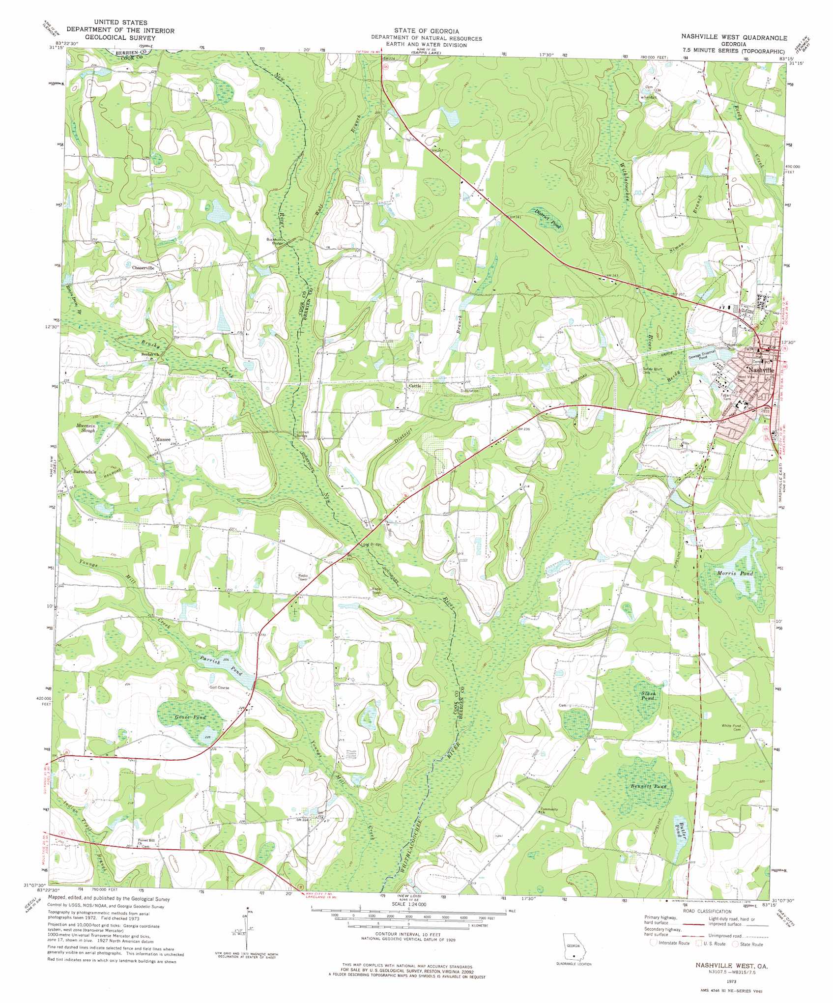
USGS Topo Quad 31083b3 - 1:24,000 scale
| Topo Map Name: | Nashville West |
| USGS Topo Quad ID: | 31083b3 |
| Print Size: | ca. 21 1/4" wide x 27" high |
| Southeast Coordinates: | 31.125° N latitude / 83.25° W longitude |
| Map Center Coordinates: | 31.1875° N latitude / 83.3125° W longitude |
| U.S. State: | GA |
| Filename: | o31083b3.jpg |
| Download Map JPG Image: | Nashville West topo map 1:24,000 scale |
| Map Type: | Topographic |
| Topo Series: | 7.5´ |
| Map Scale: | 1:24,000 |
| Source of Map Images: | United States Geological Survey (USGS) |
| Alternate Map Versions: |
Nashville West GA 1973, updated 1975 Download PDF Buy paper map Nashville West GA 2011 Download PDF Buy paper map Nashville West GA 2014 Download PDF Buy paper map |
1:24,000 Topo Quads surrounding Nashville West
Tifton West |
Tifton East |
Enigma |
Alapaha |
Lax |
Omega |
Lenox |
Sapps Lake |
Tenmile Bay |
Willacoochee |
Ellenton |
Adel |
Nashville West |
Nashville East |
Hastings Fish Pond |
Berlin East |
Cecil |
New Lois |
Ray City |
Lakeland |
Pebble Hill |
Hahira West |
Hahira East |
Bemiss |
Naylor |
> Back to 31083a1 at 1:100,000 scale
> Back to 31082a1 at 1:250,000 scale
> Back to U.S. Topo Maps home
Nashville West topo map: Gazetteer
Nashville West: Bridges
Buckholts Bridge elevation 60m 196′Connell Bridge elevation 57m 187′
Long Bridge elevation 55m 180′
Nashville West: Dams
Parrish Pond Dam elevation 63m 206′Nashville West: Lakes
Bennett Pond elevation 65m 213′Butler Pond elevation 65m 213′
District Pond elevation 71m 232′
Goose Pond elevation 69m 226′
Morris Pond elevation 66m 216′
Slash Pond elevation 65m 213′
Nashville West: Parks
Dogwood Street Recreation Area elevation 68m 223′Tygart Park elevation 72m 236′
Nashville West: Populated Places
Barnesdale elevation 72m 236′Chaserville elevation 77m 252′
Cottle elevation 73m 239′
Massee elevation 70m 229′
Nashville elevation 73m 239′
Nashville West: Post Offices
Nashville Post Office elevation 72m 236′Nashville West: Reservoirs
Parrish Pond elevation 60m 196′Nashville West: Streams
Brushy Creek elevation 57m 187′District Branch elevation 56m 183′
Futch Branch elevation 64m 209′
Moccasin Slough elevation 69m 226′
New River elevation 51m 167′
Reedy Creek elevation 58m 190′
Rosin Dam Branch elevation 62m 203′
Simon Branch elevation 60m 196′
Wolf Branch elevation 58m 190′
Nashville West digital topo map on disk
Buy this Nashville West topo map showing relief, roads, GPS coordinates and other geographical features, as a high-resolution digital map file on DVD: