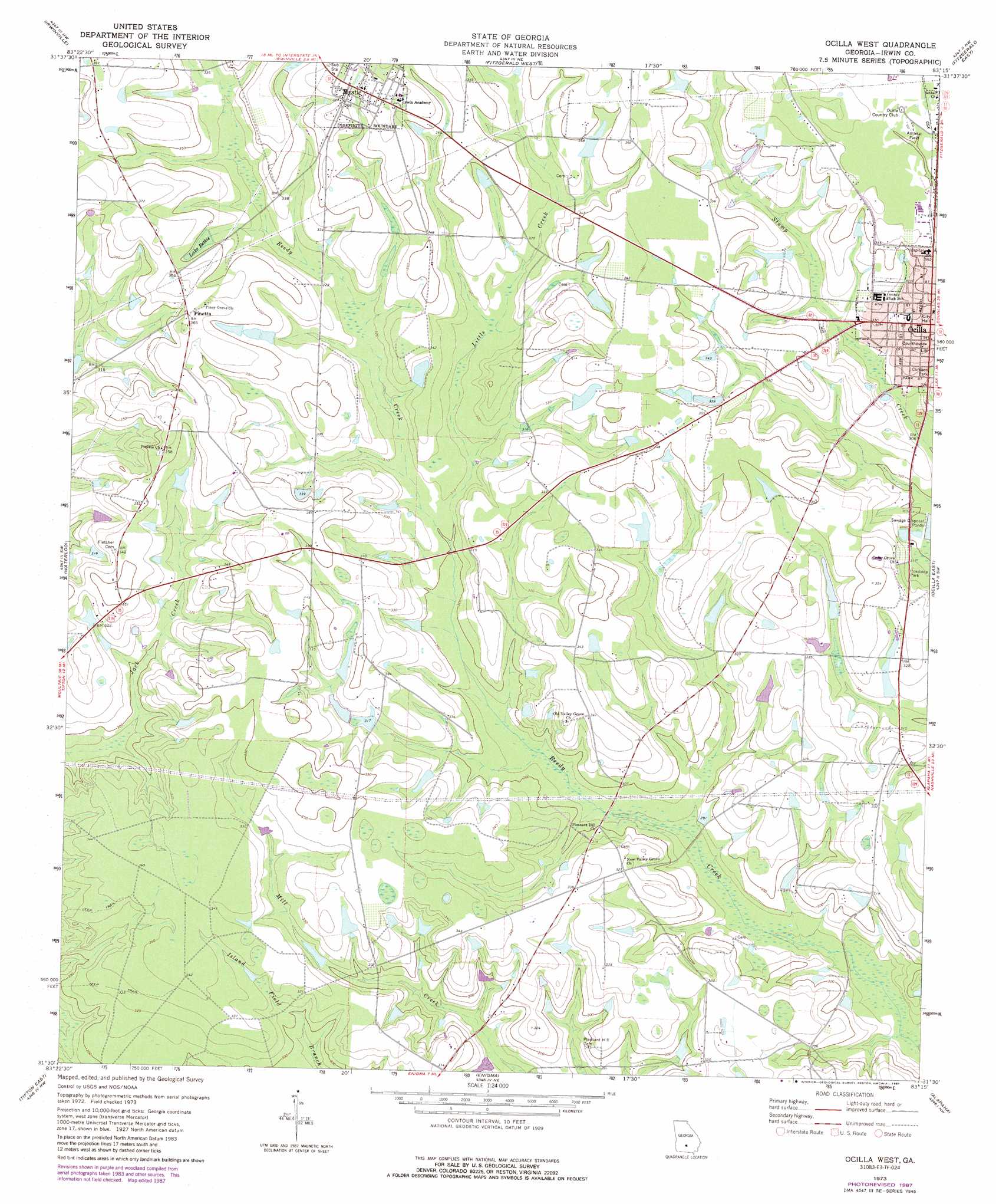
Ocilla West Topo Map Georgia
To zoom in, hover over the map of Ocilla West
USGS Topo Quad 31083e3 - 1:24,000 scale
| Topo Map Name: | Ocilla West |
| USGS Topo Quad ID: | 31083e3 |
| Print Size: | ca. 21 1/4" wide x 27" high |
| Southeast Coordinates: | 31.5° N latitude / 83.25° W longitude |
| Map Center Coordinates: | 31.5625° N latitude / 83.3125° W longitude |
| U.S. State: | GA |
| Filename: | o31083e3.jpg |
| Download Map JPG Image: | Ocilla West topo map 1:24,000 scale |
| Map Type: | Topographic |
| Topo Series: | 7.5´ |
| Map Scale: | 1:24,000 |
| Source of Map Images: | United States Geological Survey (USGS) |
| Alternate Map Versions: |
Ocilla West GA 1973, updated 1975 Download PDF Buy paper map Ocilla West GA 1973, updated 1987 Download PDF Buy paper map Ocilla West GA 2011 Download PDF Buy paper map Ocilla West GA 2014 Download PDF Buy paper map |
1:24,000 Topo Quads surrounding Ocilla West
Amboy |
Rebecca |
Sibbie |
Queensland |
China Hill |
Bethel |
Irwinville |
Fitzgerald West |
Fitzgerald East |
Osierfield |
Chula |
Waterloo |
Ocilla West |
Ocilla East |
Ambrose |
Tifton West |
Tifton East |
Enigma |
Alapaha |
Lax |
Omega |
Lenox |
Sapps Lake |
Tenmile Bay |
Willacoochee |
> Back to 31083e1 at 1:100,000 scale
> Back to 31082a1 at 1:250,000 scale
> Back to U.S. Topo Maps home
Ocilla West topo map: Gazetteer
Ocilla West: Dams
Duren Lake Dam elevation 103m 337′E Paulk Lake Dam elevation 103m 337′
Gray Lake Dam elevation 102m 334′
Little Lake Dam elevation 100m 328′
Turk Lake North Dam elevation 105m 344′
Turk Lake South Dam elevation 105m 344′
Ocilla West: Parks
Cumbee Park elevation 97m 318′Ocilla West: Populated Places
Mystic elevation 112m 367′Ocilla elevation 108m 354′
Pinetta elevation 111m 364′
Ocilla West: Post Offices
Mystic Post Office elevation 113m 370′Ocilla Post Office elevation 105m 344′
Ocilla West: Reservoirs
Duren Lake elevation 103m 337′E Paulk Lake elevation 103m 337′
Gray Lake elevation 102m 334′
Lake Bettie elevation 103m 337′
Little Lake elevation 100m 328′
Turk Lake North elevation 105m 344′
Turk Lake South elevation 105m 344′
Ocilla West: Streams
Little Creek elevation 91m 298′Ocilla West digital topo map on disk
Buy this Ocilla West topo map showing relief, roads, GPS coordinates and other geographical features, as a high-resolution digital map file on DVD: