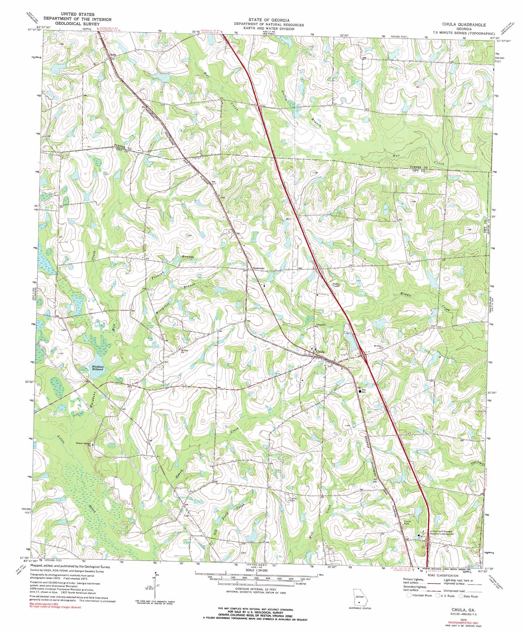
Chula Topo Map Georgia
To zoom in, hover over the map of Chula
USGS Topo Quad 31083e5 - 1:24,000 scale
| Topo Map Name: | Chula |
| USGS Topo Quad ID: | 31083e5 |
| Print Size: | ca. 21 1/4" wide x 27" high |
| Southeast Coordinates: | 31.5° N latitude / 83.5° W longitude |
| Map Center Coordinates: | 31.5625° N latitude / 83.5625° W longitude |
| U.S. State: | GA |
| Filename: | o31083e5.jpg |
| Download Map JPG Image: | Chula topo map 1:24,000 scale |
| Map Type: | Topographic |
| Topo Series: | 7.5´ |
| Map Scale: | 1:24,000 |
| Source of Map Images: | United States Geological Survey (USGS) |
| Alternate Map Versions: |
Chula GA 1973, updated 1976 Download PDF Buy paper map Chula GA 1973, updated 1991 Download PDF Buy paper map Chula GA 2011 Download PDF Buy paper map Chula GA 2014 Download PDF Buy paper map |
1:24,000 Topo Quads surrounding Chula
Pateville |
Arabi |
Amboy |
Rebecca |
Sibbie |
Cuffietown |
Ashburn |
Bethel |
Irwinville |
Fitzgerald West |
Sylvester |
Sumner |
Chula |
Waterloo |
Ocilla West |
Tempy |
Ty Ty |
Tifton West |
Tifton East |
Enigma |
Sigsbee |
Norman Park |
Omega |
Lenox |
Sapps Lake |
> Back to 31083e1 at 1:100,000 scale
> Back to 31082a1 at 1:250,000 scale
> Back to U.S. Topo Maps home
Chula topo map: Gazetteer
Chula: Crossings
Exit 22 elevation 118m 387′Exit 23 elevation 112m 367′
Exit 24 elevation 115m 377′
Chula: Dams
Allen Lake Dam elevation 99m 324′Baker Lake Dam elevation 102m 334′
Branch Lake Dam elevation 107m 351′
Derris Lake Dam Number 1 elevation 109m 357′
Garrison Lake Dam elevation 111m 364′
Jones Lake Dam Number Three elevation 108m 354′
Jones Lake Dam Number Two elevation 117m 383′
Kendrick Lake Dam elevation 95m 311′
Mar-Jan Lake Dam elevation 103m 337′
Odum Lake Dam elevation 107m 351′
Sumner Lake Dam elevation 106m 347′
Thornbill Lake Dam elevation 97m 318′
Chula: Populated Places
Chula elevation 117m 383′Inaha elevation 122m 400′
Sunsweet elevation 119m 390′
Chula: Reservoirs
Allen Lake elevation 99m 324′Baker Lake elevation 102m 334′
Branch Lake elevation 107m 351′
Derris Lake Number 1 elevation 109m 357′
Garrison Lake elevation 111m 364′
Jones Lake Number Three elevation 108m 354′
Jones Lake Number Two elevation 117m 383′
Kendrick Lake elevation 95m 311′
Mar-Jan Lake elevation 103m 337′
Odum Lake elevation 107m 351′
Sumner Lake elevation 106m 347′
Thornbill Lake elevation 97m 318′
Whiddons Millpond elevation 88m 288′
Chula: Streams
Foxhead Branch elevation 94m 308′Gulley Branch elevation 93m 305′
Heard Creek elevation 84m 275′
Whiddons Mill Creek elevation 84m 275′
Wiregrass Branch elevation 89m 291′
Chula digital topo map on disk
Buy this Chula topo map showing relief, roads, GPS coordinates and other geographical features, as a high-resolution digital map file on DVD: