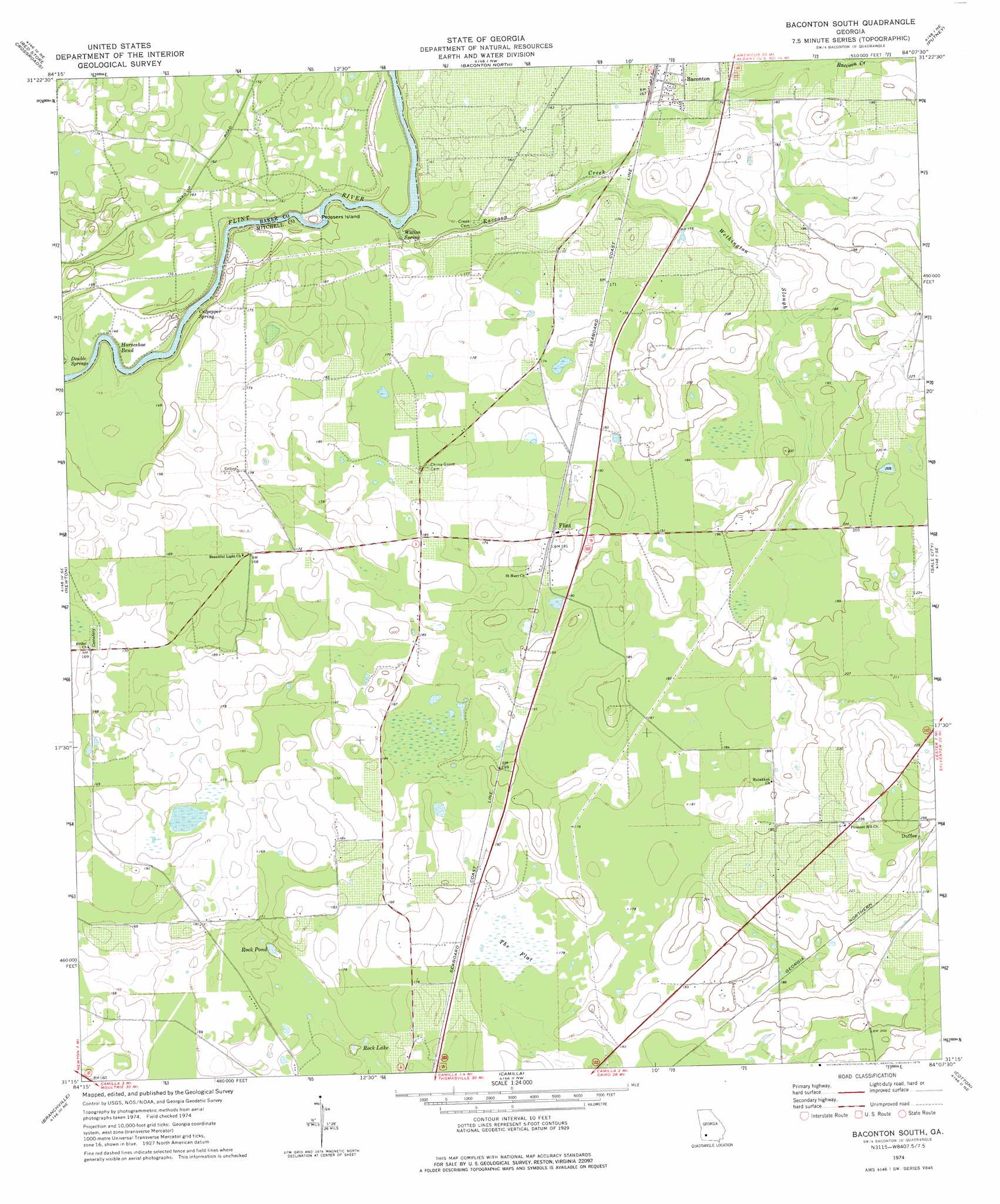
Baconton South Topo Map Georgia
To zoom in, hover over the map of Baconton South
USGS Topo Quad 31084c2 - 1:24,000 scale
| Topo Map Name: | Baconton South |
| USGS Topo Quad ID: | 31084c2 |
| Print Size: | ca. 21 1/4" wide x 27" high |
| Southeast Coordinates: | 31.25° N latitude / 84.125° W longitude |
| Map Center Coordinates: | 31.3125° N latitude / 84.1875° W longitude |
| U.S. State: | GA |
| Filename: | o31084c2.jpg |
| Download Map JPG Image: | Baconton South topo map 1:24,000 scale |
| Map Type: | Topographic |
| Topo Series: | 7.5´ |
| Map Scale: | 1:24,000 |
| Source of Map Images: | United States Geological Survey (USGS) |
| Alternate Map Versions: |
Baconton South GA 1974, updated 1976 Download PDF Buy paper map Baconton South GA 2011 Download PDF Buy paper map Baconton South GA 2014 Download PDF Buy paper map |
1:24,000 Topo Quads surrounding Baconton South
Holt |
Pretoria |
Albany West |
Albany East |
Acree |
Bermuda |
Red Store Crossroads |
Baconton North |
Putney |
Bridgeboro |
Elmodel |
Newton |
Baconton South |
Sale City |
Doerun |
Hopeful |
Branchville |
Camilla |
Cotton |
Hartsfield |
Vada |
Gee Pond |
Pelham |
Meigs |
Chastain |
> Back to 31084a1 at 1:100,000 scale
> Back to 31084a1 at 1:250,000 scale
> Back to U.S. Topo Maps home
Baconton South topo map: Gazetteer
Baconton South: Bends
Horseshoe Bend elevation 38m 124′Baconton South: Islands
Prossers Island elevation 44m 144′Baconton South: Lakes
Rock Lake elevation 48m 157′Rock Pond elevation 48m 157′
Baconton South: Populated Places
Adelaide elevation 61m 200′Flint elevation 56m 183′
Baconton South: Springs
Culpepper Spring elevation 44m 144′Double Springs elevation 42m 137′
Walton Spring elevation 45m 147′
Baconton South: Streams
Raccoon Creek elevation 46m 150′Wethington Slough elevation 46m 150′
Baconton South: Swamps
The Flat elevation 54m 177′Baconton South digital topo map on disk
Buy this Baconton South topo map showing relief, roads, GPS coordinates and other geographical features, as a high-resolution digital map file on DVD:
Gulf Coast (LA, MS, AL, FL) & Southwestern Georgia
Buy digital topo maps: Gulf Coast (LA, MS, AL, FL) & Southwestern Georgia
 & Southwestern Georgia map DVD")