Elmodel Topo Map Georgia
To zoom in, hover over the map of Elmodel
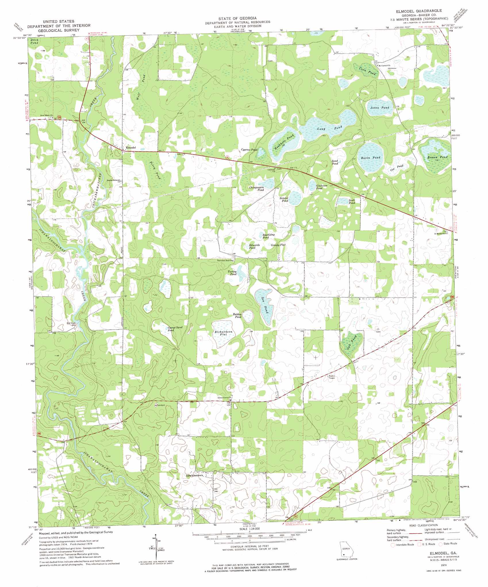
USGS Topo Quad 31084c4 - 1:24,000 scale
| Topo Map Name: | Elmodel |
| USGS Topo Quad ID: | 31084c4 |
| Print Size: | ca. 21 1/4" wide x 27" high |
| Southeast Coordinates: | 31.25° N latitude / 84.375° W longitude |
| Map Center Coordinates: | 31.3125° N latitude / 84.4375° W longitude |
| U.S. State: | GA |
| Filename: | o31084c4.jpg |
| Download Map JPG Image: | Elmodel topo map 1:24,000 scale |
| Map Type: | Topographic |
| Topo Series: | 7.5´ |
| Map Scale: | 1:24,000 |
| Source of Map Images: | United States Geological Survey (USGS) |
| Alternate Map Versions: |
Elmodel GA 1974, updated 1976 Download PDF Buy paper map Elmodel GA 2011 Download PDF Buy paper map Elmodel GA 2014 Download PDF Buy paper map |
1:24,000 Topo Quads surrounding Elmodel
Edison |
Morgan |
Holt |
Pretoria |
Albany West |
Arlington |
Leary |
Bermuda |
Red Store Crossroads |
Baconton North |
Damascus |
Bethany |
Elmodel |
Newton |
Baconton South |
Colquitt |
Cooktown |
Hopeful |
Branchville |
Camilla |
Boykin |
Steadhams Store |
Vada |
Gee Pond |
Pelham |
> Back to 31084a1 at 1:100,000 scale
> Back to 31084a1 at 1:250,000 scale
> Back to U.S. Topo Maps home
Elmodel topo map: Gazetteer
Elmodel: Flats
Grassy Flat elevation 48m 157′Richardson Flat elevation 44m 144′
Elmodel: Lakes
Balden Pond elevation 49m 160′Baptizing Pond elevation 48m 157′
Basin Pond elevation 48m 157′
Bristol Pond elevation 47m 154′
Brown Pond elevation 48m 157′
Chinquapin Pond elevation 47m 154′
Coon Pond elevation 50m 164′
Cox Pond elevation 48m 157′
Cypress Pond elevation 48m 157′
Edwards Pond elevation 48m 157′
George Sand Pond elevation 44m 144′
Ginhouse Pond elevation 47m 154′
Jones Pond elevation 48m 157′
Long Pond elevation 47m 154′
Oak Pond elevation 47m 154′
Perry Pond elevation 49m 160′
Rockhole Pond elevation 48m 157′
Sand Pond elevation 51m 167′
Sea Pond elevation 45m 147′
Turkey Pond elevation 47m 154′
Wolf Pond elevation 49m 160′
Elmodel: Populated Places
Elmodel elevation 49m 160′Hawkinstown elevation 49m 160′
Elmodel: Streams
Chickasawhatchee Creek elevation 41m 134′Elmodel: Swamps
Duck Pond elevation 52m 170′Elmodel digital topo map on disk
Buy this Elmodel topo map showing relief, roads, GPS coordinates and other geographical features, as a high-resolution digital map file on DVD:
Gulf Coast (LA, MS, AL, FL) & Southwestern Georgia
Buy digital topo maps: Gulf Coast (LA, MS, AL, FL) & Southwestern Georgia
 & Southwestern Georgia map DVD")