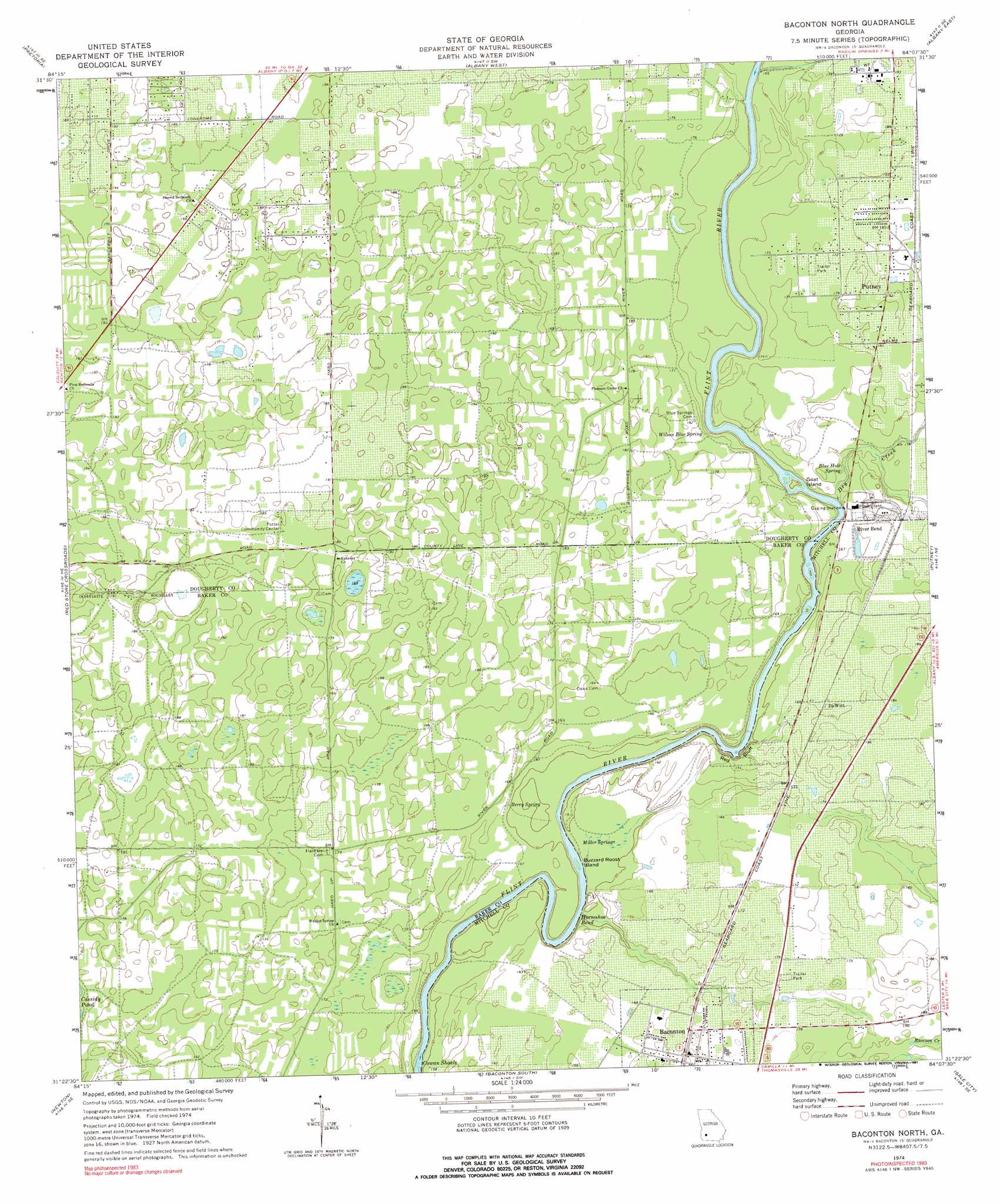
Baconton North Topo Map Georgia
To zoom in, hover over the map of Baconton North
USGS Topo Quad 31084d2 - 1:24,000 scale
| Topo Map Name: | Baconton North |
| USGS Topo Quad ID: | 31084d2 |
| Print Size: | ca. 21 1/4" wide x 27" high |
| Southeast Coordinates: | 31.375° N latitude / 84.125° W longitude |
| Map Center Coordinates: | 31.4375° N latitude / 84.1875° W longitude |
| U.S. State: | GA |
| Filename: | o31084d2.jpg |
| Download Map JPG Image: | Baconton North topo map 1:24,000 scale |
| Map Type: | Topographic |
| Topo Series: | 7.5´ |
| Map Scale: | 1:24,000 |
| Source of Map Images: | United States Geological Survey (USGS) |
| Alternate Map Versions: |
Baconton North GA 1974, updated 1976 Download PDF Buy paper map Baconton North GA 1974, updated 1991 Download PDF Buy paper map Baconton North GA 2011 Download PDF Buy paper map Baconton North GA 2014 Download PDF Buy paper map |
1:24,000 Topo Quads surrounding Baconton North
Chickasawhatchee |
Sasser |
Leesburg |
Albany Ne |
Doles |
Holt |
Pretoria |
Albany West |
Albany East |
Acree |
Bermuda |
Red Store Crossroads |
Baconton North |
Putney |
Bridgeboro |
Elmodel |
Newton |
Baconton South |
Sale City |
Doerun |
Hopeful |
Branchville |
Camilla |
Cotton |
Hartsfield |
> Back to 31084a1 at 1:100,000 scale
> Back to 31084a1 at 1:250,000 scale
> Back to U.S. Topo Maps home
Baconton North topo map: Gazetteer
Baconton North: Bars
Cowan Shoals elevation 41m 134′Baconton North: Bends
Horseshoe Bend elevation 46m 150′Baconton North: Cliffs
Red Bluff elevation 53m 173′Baconton North: Islands
Buzzard Roost Island elevation 42m 137′Goat Island elevation 46m 150′
Baconton North: Populated Places
Baconton elevation 53m 173′DeWitt elevation 52m 170′
River Bend elevation 53m 173′
Baconton North: Post Offices
Baconton Post Office elevation 52m 170′Baconton North: Springs
Berry Spring elevation 46m 150′Blue Hole Spring elevation 50m 164′
Miller Springs elevation 43m 141′
Wilson Blue Spring elevation 46m 150′
Baconton North: Streams
Dry Creek elevation 50m 164′Baconton North digital topo map on disk
Buy this Baconton North topo map showing relief, roads, GPS coordinates and other geographical features, as a high-resolution digital map file on DVD:
Gulf Coast (LA, MS, AL, FL) & Southwestern Georgia
Buy digital topo maps: Gulf Coast (LA, MS, AL, FL) & Southwestern Georgia
 & Southwestern Georgia map DVD")