Bluffton Topo Map Georgia
To zoom in, hover over the map of Bluffton
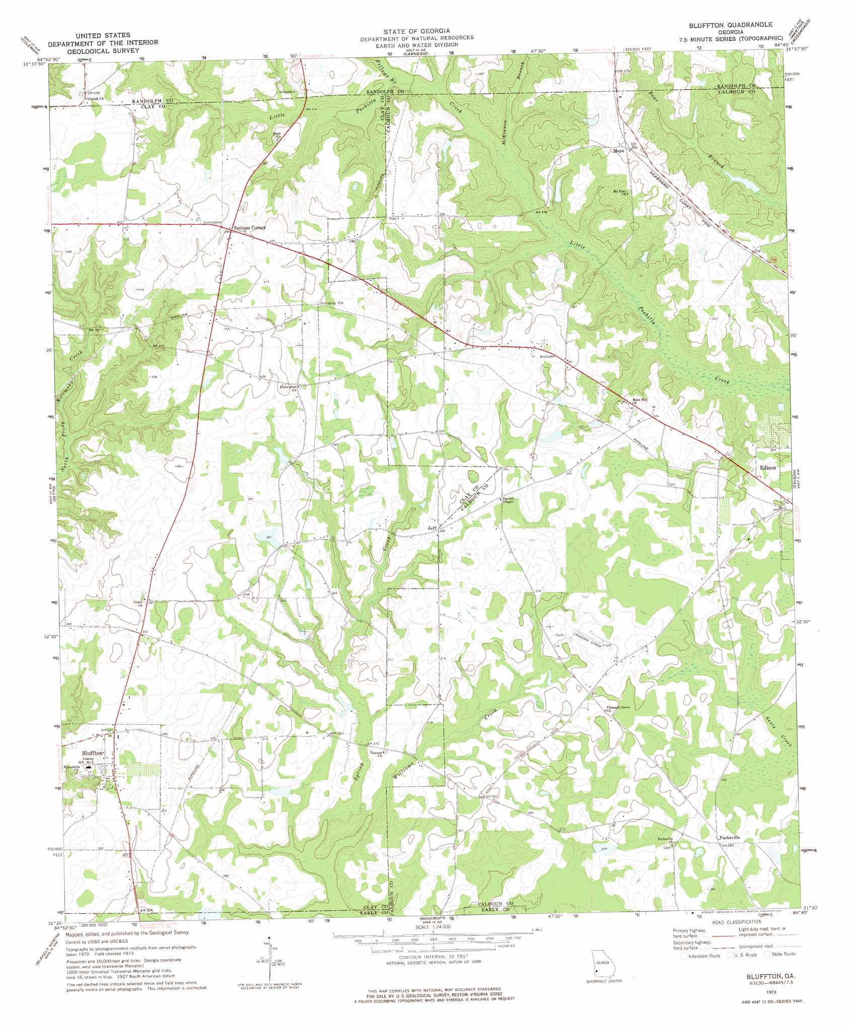
USGS Topo Quad 31084e7 - 1:24,000 scale
| Topo Map Name: | Bluffton |
| USGS Topo Quad ID: | 31084e7 |
| Print Size: | ca. 21 1/4" wide x 27" high |
| Southeast Coordinates: | 31.5° N latitude / 84.75° W longitude |
| Map Center Coordinates: | 31.5625° N latitude / 84.8125° W longitude |
| U.S. State: | GA |
| Filename: | o31084e7.jpg |
| Download Map JPG Image: | Bluffton topo map 1:24,000 scale |
| Map Type: | Topographic |
| Topo Series: | 7.5´ |
| Map Scale: | 1:24,000 |
| Source of Map Images: | United States Geological Survey (USGS) |
| Alternate Map Versions: |
Bluffton GA 1973, updated 1975 Download PDF Buy paper map Bluffton GA 2011 Download PDF Buy paper map Bluffton GA 2014 Download PDF Buy paper map |
1:24,000 Topo Quads surrounding Bluffton
Hatcher |
Morris |
Cuthbert |
Brooksville |
Shellman |
Fort Gaines Ne |
Coleman |
Carnegie |
Martins Crossroads |
Doverel |
Fort Gaines |
Zetto |
Bluffton |
Edison |
Morgan |
Columbia Ne |
Blakely North |
Bancroft |
Arlington |
Leary |
Columbia |
Blakely South |
Hentown |
Damascus |
Bethany |
> Back to 31084e1 at 1:100,000 scale
> Back to 31084a1 at 1:250,000 scale
> Back to U.S. Topo Maps home
Bluffton topo map: Gazetteer
Bluffton: Dams
Faines Lake Dam elevation 108m 354′Hattaway Lake Dam elevation 102m 334′
Bluffton: Populated Places
Blackburns Store (historical) elevation 132m 433′Bluffton elevation 97m 318′
Jeff elevation 100m 328′
Moye elevation 113m 370′
Oakland elevation 123m 403′
Parksville elevation 88m 288′
Suttons Corner elevation 120m 393′
Bluffton: Reservoirs
Faines Lake elevation 108m 354′Hattaway Lake elevation 102m 334′
Bluffton: Streams
Fellows Branch elevation 89m 291′McKinnon Branch elevation 85m 278′
Williams Creek elevation 75m 246′
Bluffton digital topo map on disk
Buy this Bluffton topo map showing relief, roads, GPS coordinates and other geographical features, as a high-resolution digital map file on DVD:
Gulf Coast (LA, MS, AL, FL) & Southwestern Georgia
Buy digital topo maps: Gulf Coast (LA, MS, AL, FL) & Southwestern Georgia
 & Southwestern Georgia map DVD")