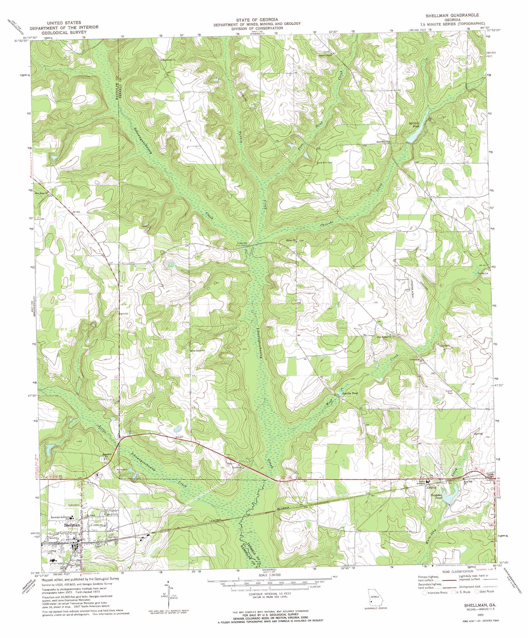
Shellman Topo Map Georgia
To zoom in, hover over the map of Shellman
USGS Topo Quad 31084g5 - 1:24,000 scale
| Topo Map Name: | Shellman |
| USGS Topo Quad ID: | 31084g5 |
| Print Size: | ca. 21 1/4" wide x 27" high |
| Southeast Coordinates: | 31.75° N latitude / 84.5° W longitude |
| Map Center Coordinates: | 31.8125° N latitude / 84.5625° W longitude |
| U.S. State: | GA |
| Filename: | o31084g5.jpg |
| Download Map JPG Image: | Shellman topo map 1:24,000 scale |
| Map Type: | Topographic |
| Topo Series: | 7.5´ |
| Map Scale: | 1:24,000 |
| Source of Map Images: | United States Geological Survey (USGS) |
| Alternate Map Versions: |
Shellman GA 1972, updated 1974 Download PDF Buy paper map Shellman GA 2011 Download PDF Buy paper map Shellman GA 2014 Download PDF Buy paper map |
1:24,000 Topo Quads surrounding Shellman
Lumpkin |
Richland |
Preston |
Plains |
Lake Collins |
County Line |
Benevolence |
Parrott |
Bottsford |
Smithville West |
Cuthbert |
Brooksville |
Shellman |
Dawson |
Bronwood |
Carnegie |
Martins Crossroads |
Doverel |
Chickasawhatchee |
Sasser |
Bluffton |
Edison |
Morgan |
Holt |
Pretoria |
> Back to 31084e1 at 1:100,000 scale
> Back to 31084a1 at 1:250,000 scale
> Back to U.S. Topo Maps home
Shellman topo map: Gazetteer
Shellman: Dams
McGills Pond Dam elevation 102m 334′Stephens Pond Dam elevation 100m 328′
Shellman: Lakes
Smiths Pond elevation 89m 291′Shellman: Parks
Ichawaynochaway Monument elevation 94m 308′Shellman Historic District elevation 119m 390′
Shellman: Populated Places
Graves elevation 110m 360′Shellman elevation 117m 383′
Shellman: Reservoirs
McGills Pond elevation 102m 334′Stephans Pond elevation 100m 328′
Stephens Pond elevation 96m 314′
Shellman: Streams
Chenube Creek elevation 91m 298′Little Ichawaynochaway Creek elevation 85m 278′
Pine Head Creek elevation 94m 308′
Turkey Creek elevation 93m 305′
Wolf Creek elevation 88m 288′
Shellman digital topo map on disk
Buy this Shellman topo map showing relief, roads, GPS coordinates and other geographical features, as a high-resolution digital map file on DVD:
Gulf Coast (LA, MS, AL, FL) & Southwestern Georgia
Buy digital topo maps: Gulf Coast (LA, MS, AL, FL) & Southwestern Georgia
 & Southwestern Georgia map DVD")