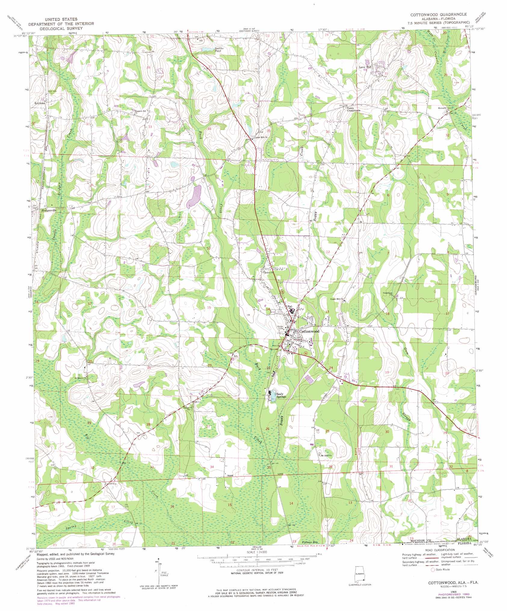
Cottonwood Topo Map Alabama
To zoom in, hover over the map of Cottonwood
USGS Topo Quad 31085a3 - 1:24,000 scale
| Topo Map Name: | Cottonwood |
| USGS Topo Quad ID: | 31085a3 |
| Print Size: | ca. 21 1/4" wide x 27" high |
| Southeast Coordinates: | 31° N latitude / 85.25° W longitude |
| Map Center Coordinates: | 31.0625° N latitude / 85.3125° W longitude |
| U.S. States: | AL, FL |
| Filename: | o31085a3.jpg |
| Download Map JPG Image: | Cottonwood topo map 1:24,000 scale |
| Map Type: | Topographic |
| Topo Series: | 7.5´ |
| Map Scale: | 1:24,000 |
| Source of Map Images: | United States Geological Survey (USGS) |
| Alternate Map Versions: |
Cottonwood AL 1969, updated 1972 Download PDF Buy paper map Cottonwood AL 1969, updated 1981 Download PDF Buy paper map Cottonwood AL 2011 Download PDF Buy paper map Cottonwood AL 2014 Download PDF Buy paper map |
1:24,000 Topo Quads surrounding Cottonwood
Pinckard |
Midland City |
Headland |
Sigma |
Columbia |
Malvern |
Dothan West |
Dothan East |
Ashford |
Gordon |
Slocomb |
Madrid |
Cottonwood |
Grangeburg |
Saffold |
Graceville |
Campbellton |
Sills |
Malone |
Bascom |
Chipley |
Cottondale West |
Cottondale East |
Marianna |
Dellwood |
> Back to 31085a1 at 1:100,000 scale
> Back to 31084a1 at 1:250,000 scale
> Back to U.S. Topo Maps home
Cottonwood topo map: Gazetteer
Cottonwood: Dams
Gerald Crowley Lake and Dam elevation 55m 180′Cottonwood: Parks
Hicks Field elevation 50m 164′Cottonwood: Populated Places
Cottonwood elevation 50m 164′Hodgesville elevation 59m 193′
Keytons elevation 70m 229′
Love Hill elevation 74m 242′
Sealy Springs elevation 42m 137′
Terry Crossroads elevation 74m 242′
Cottonwood: Post Offices
Cottonwood Post Office elevation 51m 167′Cottonwood: Reservoirs
Smiths Pond elevation 67m 219′Cottonwood: Streams
Big Creek elevation 34m 111′Boggy Creek elevation 33m 108′
Mill Creek elevation 48m 157′
Spring Creek elevation 33m 108′
Webb Creek elevation 49m 160′
Cottonwood: Swamps
Pittman Bay elevation 35m 114′Cottonwood digital topo map on disk
Buy this Cottonwood topo map showing relief, roads, GPS coordinates and other geographical features, as a high-resolution digital map file on DVD:
Gulf Coast (LA, MS, AL, FL) & Southwestern Georgia
Buy digital topo maps: Gulf Coast (LA, MS, AL, FL) & Southwestern Georgia
 & Southwestern Georgia map DVD")