Hartford Topo Map Alabama
To zoom in, hover over the map of Hartford
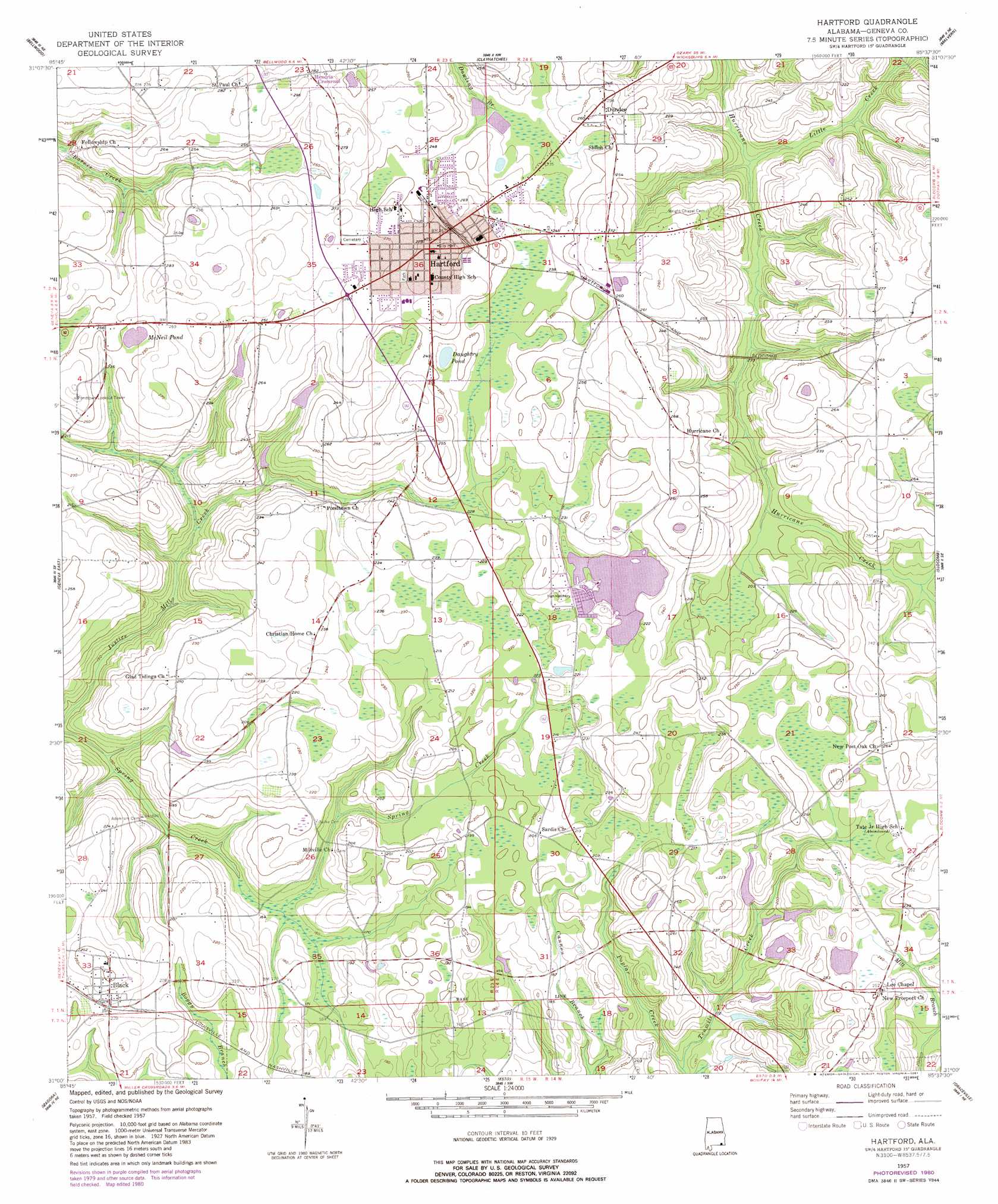
USGS Topo Quad 31085a6 - 1:24,000 scale
| Topo Map Name: | Hartford |
| USGS Topo Quad ID: | 31085a6 |
| Print Size: | ca. 21 1/4" wide x 27" high |
| Southeast Coordinates: | 31° N latitude / 85.625° W longitude |
| Map Center Coordinates: | 31.0625° N latitude / 85.6875° W longitude |
| U.S. State: | AL |
| Filename: | o31085a6.jpg |
| Download Map JPG Image: | Hartford topo map 1:24,000 scale |
| Map Type: | Topographic |
| Topo Series: | 7.5´ |
| Map Scale: | 1:24,000 |
| Source of Map Images: | United States Geological Survey (USGS) |
| Alternate Map Versions: |
Hartford AL 1957, updated 1958 Download PDF Buy paper map Hartford AL 1957, updated 1958 Download PDF Buy paper map Hartford AL 1957, updated 1981 Download PDF Buy paper map Hartford AL 2011 Download PDF Buy paper map Hartford AL 2014 Download PDF Buy paper map |
1:24,000 Topo Quads surrounding Hartford
Goodman |
Enterprise |
Daleville |
Pinckard |
Midland City |
Coffee Springs |
Bellwood |
Clayhatchee |
Malvern |
Dothan West |
Geneva West |
Geneva East |
Hartford |
Slocomb |
Madrid |
Hobbs Crossroads |
Izagora |
Esto |
Graceville |
Campbellton |
Prosperity |
Caryville |
Bonifay |
Chipley |
Cottondale West |
> Back to 31085a1 at 1:100,000 scale
> Back to 31084a1 at 1:250,000 scale
> Back to U.S. Topo Maps home
Hartford topo map: Gazetteer
Hartford: Dams
Hartford Lake Number 1 Dam elevation 65m 213′Hartford Lake Number 2 Dam elevation 65m 213′
J A Hughes Lake Number 3 Dam elevation 75m 246′
Paul Kennedy Number 1 Dam elevation 73m 239′
Paul Kennedy Number 2 Dam elevation 72m 236′
Paul Kennedy Number 3 Dam elevation 61m 200′
Paul Kennedy Number 4 Dam elevation 64m 209′
Paul Kennedy Number 5 Dam elevation 67m 219′
Hartford: Lakes
Burch Pond elevation 73m 239′Daughtry Pond elevation 71m 232′
Hartford Lake elevation 65m 213′
McNeil Pond elevation 75m 246′
Hartford: Populated Places
Black elevation 69m 226′Dundee elevation 78m 255′
Hartford elevation 83m 272′
Millville (historical) elevation 53m 173′
Warwick (historical) elevation 76m 249′
Hartford: Post Offices
Black Post Office elevation 71m 232′Hartford Post Office (historical) elevation 82m 269′
Hartford: Reservoirs
Kennedy Lakes elevation 73m 239′Kennedy Lakes elevation 72m 236′
Kennedy Lakes elevation 61m 200′
Kennedy Lakes elevation 67m 219′
Kennedy Lakes elevation 64m 209′
Hartford: Streams
Burch Creek elevation 54m 177′Little Creek elevation 51m 167′
Pine Log Branch elevation 62m 203′
Poplar Creek elevation 48m 157′
Wolfpen Branch elevation 62m 203′
Hartford digital topo map on disk
Buy this Hartford topo map showing relief, roads, GPS coordinates and other geographical features, as a high-resolution digital map file on DVD:
Gulf Coast (LA, MS, AL, FL) & Southwestern Georgia
Buy digital topo maps: Gulf Coast (LA, MS, AL, FL) & Southwestern Georgia
 & Southwestern Georgia map DVD")