Clayhatchee Topo Map Alabama
To zoom in, hover over the map of Clayhatchee
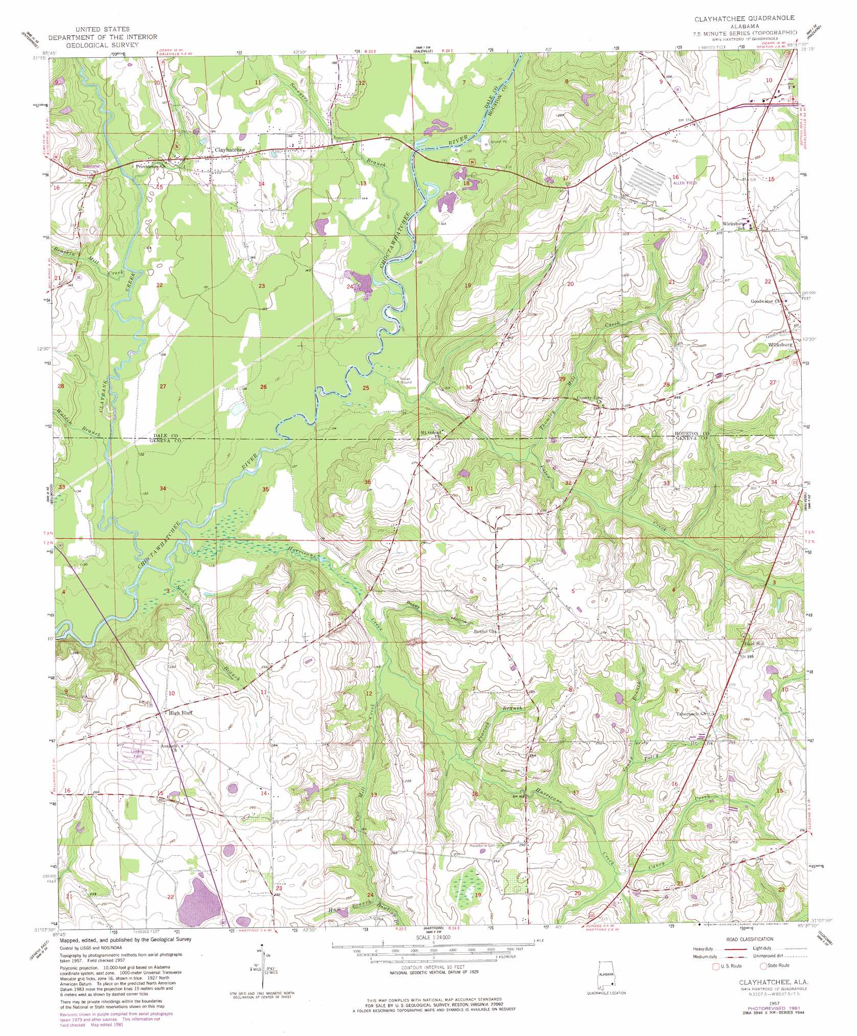
USGS Topo Quad 31085b6 - 1:24,000 scale
| Topo Map Name: | Clayhatchee |
| USGS Topo Quad ID: | 31085b6 |
| Print Size: | ca. 21 1/4" wide x 27" high |
| Southeast Coordinates: | 31.125° N latitude / 85.625° W longitude |
| Map Center Coordinates: | 31.1875° N latitude / 85.6875° W longitude |
| U.S. State: | AL |
| Filename: | o31085b6.jpg |
| Download Map JPG Image: | Clayhatchee topo map 1:24,000 scale |
| Map Type: | Topographic |
| Topo Series: | 7.5´ |
| Map Scale: | 1:24,000 |
| Source of Map Images: | United States Geological Survey (USGS) |
| Alternate Map Versions: |
Clayhatchee AL 1957, updated 1959 Download PDF Buy paper map Clayhatchee AL 1957, updated 1977 Download PDF Buy paper map Clayhatchee AL 1957, updated 1981 Download PDF Buy paper map Clayhatchee AL 1957, updated 1981 Download PDF Buy paper map Clayhatchee AL 2011 Download PDF Buy paper map Clayhatchee AL 2014 Download PDF Buy paper map |
1:24,000 Topo Quads surrounding Clayhatchee
New Brockton |
Enterprise Ne |
Ozark |
Ewell |
Echo |
Goodman |
Enterprise |
Daleville |
Pinckard |
Midland City |
Coffee Springs |
Bellwood |
Clayhatchee |
Malvern |
Dothan West |
Geneva West |
Geneva East |
Hartford |
Slocomb |
Madrid |
Hobbs Crossroads |
Izagora |
Esto |
Graceville |
Campbellton |
> Back to 31085a1 at 1:100,000 scale
> Back to 31084a1 at 1:250,000 scale
> Back to U.S. Topo Maps home
Clayhatchee topo map: Gazetteer
Clayhatchee: Crossings
Turners Ferry (historical) elevation 35m 114′Clayhatchee: Dams
Ted Sketo Dam elevation 64m 209′Clayhatchee: Parks
Panther Stadium elevation 96m 314′Clayhatchee: Populated Places
Backems Crossroads elevation 107m 351′Bald Hill elevation 88m 288′
Clayhatchee elevation 59m 193′
High Bluff elevation 83m 272′
Clayhatchee: Reservoirs
Ted Sketo Lake elevation 64m 209′Clayhatchee: Streams
Biffords Branch elevation 38m 124′Brackin Mill Creek elevation 39m 127′
Caney Creek elevation 47m 154′
Claybank Creek elevation 33m 108′
Cox Mill Creek elevation 40m 131′
Dowling Branch elevation 59m 193′
Ham Branch elevation 59m 193′
Hurricane Creek elevation 33m 108′
Pates Creek elevation 35m 114′
Peacock Branch elevation 43m 141′
Poley Branch elevation 51m 167′
Sandy Branch elevation 45m 147′
Sconyers Branch elevation 36m 118′
Spann Branch elevation 33m 108′
Thomley Mill Creek elevation 44m 144′
Walden Branch elevation 36m 118′
Clayhatchee: Valleys
Posey Hollow elevation 43m 141′Clayhatchee digital topo map on disk
Buy this Clayhatchee topo map showing relief, roads, GPS coordinates and other geographical features, as a high-resolution digital map file on DVD:
Gulf Coast (LA, MS, AL, FL) & Southwestern Georgia
Buy digital topo maps: Gulf Coast (LA, MS, AL, FL) & Southwestern Georgia
 & Southwestern Georgia map DVD")