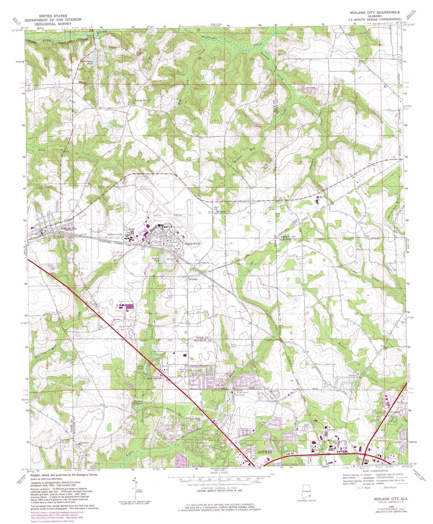
Midland City Topo Map Alabama
To zoom in, hover over the map of Midland City
USGS Topo Quad 31085c4 - 1:24,000 scale
| Topo Map Name: | Midland City |
| USGS Topo Quad ID: | 31085c4 |
| Print Size: | ca. 21 1/4" wide x 27" high |
| Southeast Coordinates: | 31.25° N latitude / 85.375° W longitude |
| Map Center Coordinates: | 31.3125° N latitude / 85.4375° W longitude |
| U.S. State: | AL |
| Filename: | o31085c4.jpg |
| Download Map JPG Image: | Midland City topo map 1:24,000 scale |
| Map Type: | Topographic |
| Topo Series: | 7.5´ |
| Map Scale: | 1:24,000 |
| Source of Map Images: | United States Geological Survey (USGS) |
| Alternate Map Versions: |
Midland City AL 1969, updated 1971 Download PDF Buy paper map Midland City AL 1969, updated 1981 Download PDF Buy paper map Midland City AL 2011 Download PDF Buy paper map Midland City AL 2014 Download PDF Buy paper map |
1:24,000 Topo Quads surrounding Midland City
Ariton |
Skipperville |
Clopton |
Abbeville West |
Abbeville East |
Ozark |
Ewell |
Echo |
Newville |
Haleburg |
Daleville |
Pinckard |
Midland City |
Headland |
Sigma |
Clayhatchee |
Malvern |
Dothan West |
Dothan East |
Ashford |
Hartford |
Slocomb |
Madrid |
Cottonwood |
Grangeburg |
> Back to 31085a1 at 1:100,000 scale
> Back to 31084a1 at 1:250,000 scale
> Back to U.S. Topo Maps home
Midland City topo map: Gazetteer
Midland City: Airports
Dothan Airport elevation 116m 380′Midland City: Bridges
Prestons Bridge elevation 57m 187′Midland City: Parks
Baumans Pond Park elevation 88m 288′Kelly Springs Recreation Area elevation 74m 242′
Landmark Park elevation 79m 259′
Murphys Mill Historical Site elevation 73m 239′
Midland City: Populated Places
Bama Dale elevation 91m 298′Brentwood elevation 78m 255′
Denton Acres elevation 101m 331′
Grand Acres elevation 104m 341′
Griffin Heights elevation 91m 298′
Grimes elevation 114m 374′
Kelly Springs elevation 104m 341′
Midland City elevation 115m 377′
Napier Field elevation 114m 374′
Oakland Estates elevation 101m 331′
Peach Tree Hills elevation 84m 275′
Rock Creek Park elevation 89m 291′
Sylvan Grove elevation 107m 351′
Woodsvale elevation 98m 321′
Young America elevation 86m 282′
Midland City: Post Offices
Midland City Post Office (historical) elevation 116m 380′Midland City: Reservoirs
Acherman Pond elevation 72m 236′Howell Pond elevation 102m 334′
Kelly Lake elevation 79m 259′
Murphy Millpond elevation 70m 229′
Midland City: Streams
Bay Log Creek elevation 70m 229′Dunham Creek elevation 70m 229′
McKays Mill Creek elevation 72m 236′
Murphy Mill Branch elevation 64m 209′
Rock Creek elevation 67m 219′
Midland City digital topo map on disk
Buy this Midland City topo map showing relief, roads, GPS coordinates and other geographical features, as a high-resolution digital map file on DVD:
Gulf Coast (LA, MS, AL, FL) & Southwestern Georgia
Buy digital topo maps: Gulf Coast (LA, MS, AL, FL) & Southwestern Georgia
 & Southwestern Georgia map DVD")