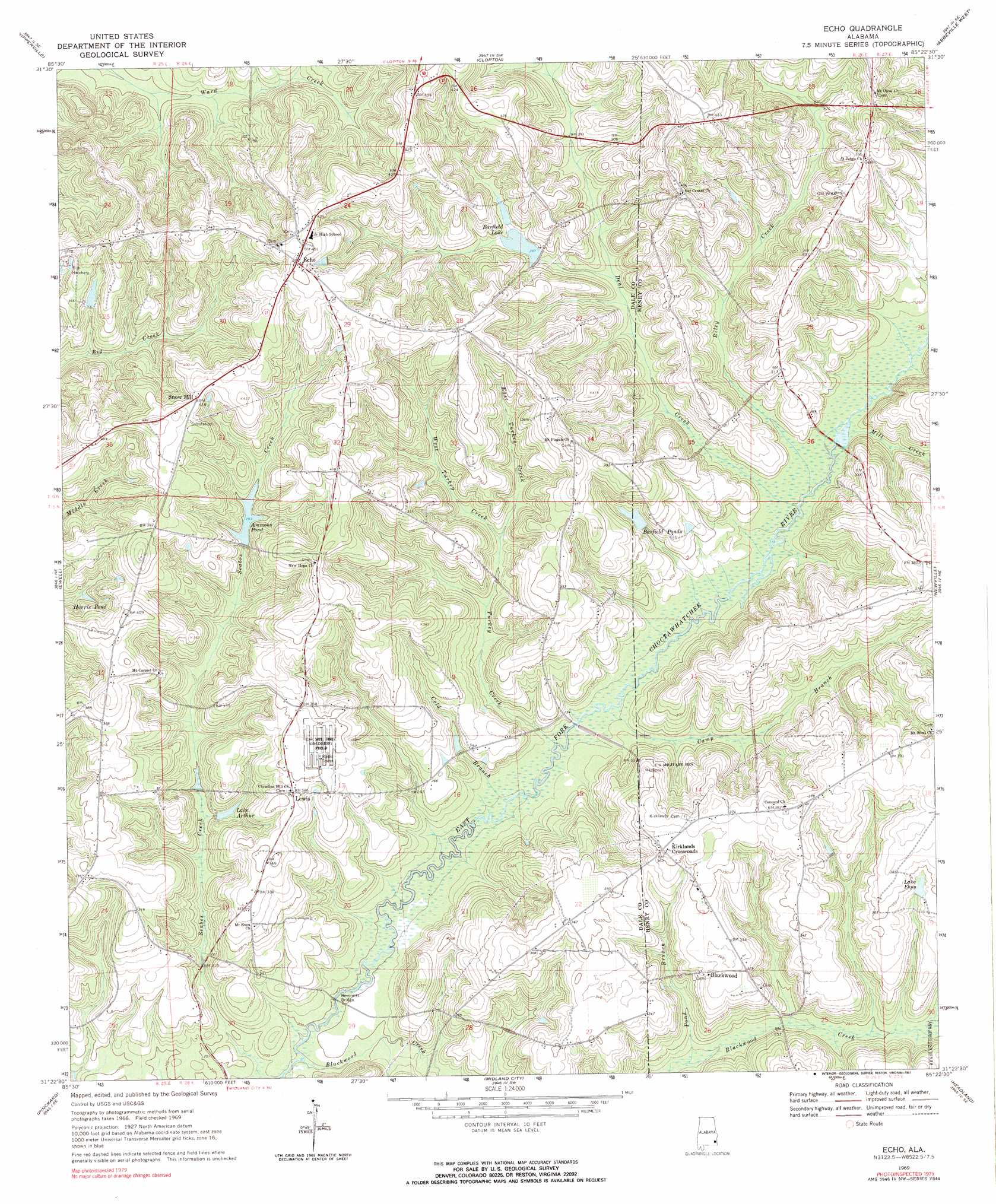
Echo Topo Map Alabama
To zoom in, hover over the map of Echo
USGS Topo Quad 31085d4 - 1:24,000 scale
| Topo Map Name: | Echo |
| USGS Topo Quad ID: | 31085d4 |
| Print Size: | ca. 21 1/4" wide x 27" high |
| Southeast Coordinates: | 31.375° N latitude / 85.375° W longitude |
| Map Center Coordinates: | 31.4375° N latitude / 85.4375° W longitude |
| U.S. State: | AL |
| Filename: | o31085d4.jpg |
| Download Map JPG Image: | Echo topo map 1:24,000 scale |
| Map Type: | Topographic |
| Topo Series: | 7.5´ |
| Map Scale: | 1:24,000 |
| Source of Map Images: | United States Geological Survey (USGS) |
| Alternate Map Versions: |
Echo AL 1969, updated 1971 Download PDF Buy paper map Echo AL 1969, updated 1990 Download PDF Buy paper map Echo AL 2011 Download PDF Buy paper map Echo AL 2014 Download PDF Buy paper map |
1:24,000 Topo Quads surrounding Echo
Elamville |
Clio |
Texasville |
Lawrenceville |
Fort Gaines Nw |
Ariton |
Skipperville |
Clopton |
Abbeville West |
Abbeville East |
Ozark |
Ewell |
Echo |
Newville |
Haleburg |
Daleville |
Pinckard |
Midland City |
Headland |
Sigma |
Clayhatchee |
Malvern |
Dothan West |
Dothan East |
Ashford |
> Back to 31085a1 at 1:100,000 scale
> Back to 31084a1 at 1:250,000 scale
> Back to U.S. Topo Maps home
Echo topo map: Gazetteer
Echo: Bridges
Beveretts Bridge elevation 59m 193′Echo: Dams
A N Ingram Dam elevation 70m 229′Jerry Mcdaniel Lake Dam elevation 84m 275′
Malchom Ammons Dam elevation 89m 291′
Otis Barfield Dam elevation 88m 288′
Echo: Populated Places
Blackwood elevation 102m 334′Echo elevation 138m 452′
Kirklands Crossroads elevation 109m 357′
Lewis elevation 106m 347′
Snow Hill elevation 127m 416′
Echo: Reservoirs
Ammons Pond elevation 89m 291′Barfield Lake elevation 88m 288′
Barfield Ponds elevation 84m 275′
Harris Pond elevation 88m 288′
Ingram Lake elevation 70m 229′
Jerry Mcdaniel Lake elevation 84m 275′
Lake Arthur elevation 78m 255′
Lake Espy elevation 100m 328′
Echo: Streams
Bells Branch elevation 83m 272′Blackwood Creek elevation 58m 190′
Camp Branch elevation 66m 216′
Cold Branch elevation 62m 203′
Deal Creek elevation 70m 229′
East Turkey Creek elevation 78m 255′
Little Blackwood Creek elevation 78m 255′
Melvin Creek elevation 61m 200′
Mill Creek elevation 72m 236′
Pond Branch elevation 68m 223′
Riley Creek elevation 70m 229′
Seabes Creek elevation 57m 187′
Turkey Creek elevation 63m 206′
West Turkey Creek elevation 78m 255′
Echo digital topo map on disk
Buy this Echo topo map showing relief, roads, GPS coordinates and other geographical features, as a high-resolution digital map file on DVD:
Gulf Coast (LA, MS, AL, FL) & Southwestern Georgia
Buy digital topo maps: Gulf Coast (LA, MS, AL, FL) & Southwestern Georgia
 & Southwestern Georgia map DVD")