Enterprise Ne Topo Map Alabama
To zoom in, hover over the map of Enterprise Ne
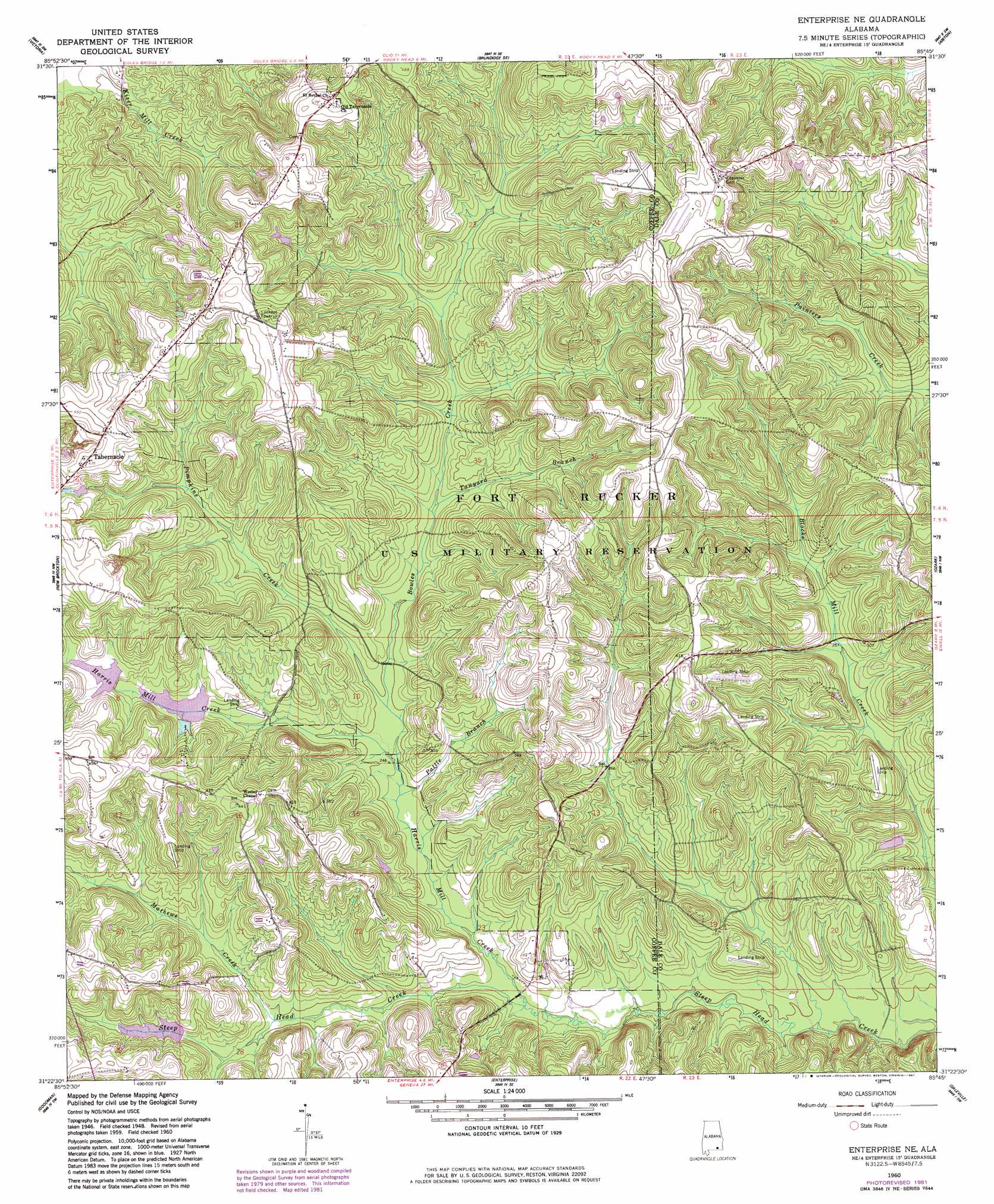
USGS Topo Quad 31085d7 - 1:24,000 scale
| Topo Map Name: | Enterprise Ne |
| USGS Topo Quad ID: | 31085d7 |
| Print Size: | ca. 21 1/4" wide x 27" high |
| Southeast Coordinates: | 31.375° N latitude / 85.75° W longitude |
| Map Center Coordinates: | 31.4375° N latitude / 85.8125° W longitude |
| U.S. State: | AL |
| Filename: | o31085d7.jpg |
| Download Map JPG Image: | Enterprise Ne topo map 1:24,000 scale |
| Map Type: | Topographic |
| Topo Series: | 7.5´ |
| Map Scale: | 1:24,000 |
| Source of Map Images: | United States Geological Survey (USGS) |
| Alternate Map Versions: |
Enterprise NE AL 1960, updated 1963 Download PDF Buy paper map Enterprise NE AL 1960, updated 1981 Download PDF Buy paper map Enterprise NE AL 2011 Download PDF Buy paper map Enterprise NE AL 2014 Download PDF Buy paper map |
1:24,000 Topo Quads surrounding Enterprise Ne
Goshen |
Brundidge Nw |
Brundidge |
Elamville |
Clio |
Bluff Springs |
Victoria |
Brundidge Se |
Ariton |
Skipperville |
Elba |
New Brockton |
Enterprise Ne |
Ozark |
Ewell |
Ino |
Goodman |
Enterprise |
Daleville |
Pinckard |
Sellersville |
Coffee Springs |
Bellwood |
Clayhatchee |
Malvern |
> Back to 31085a1 at 1:100,000 scale
> Back to 31084a1 at 1:250,000 scale
> Back to U.S. Topo Maps home
Enterprise Ne topo map: Gazetteer
Enterprise Ne: Bridges
Parish Bridge elevation 63m 206′Enterprise Ne: Dams
Boy Scout Lake Dam elevation 85m 278′Gateway Lake Dam elevation 84m 275′
Pittman Brothers Lake Dam elevation 102m 334′
Enterprise Ne: Populated Places
Gateway Estates elevation 102m 334′Tabernacle elevation 133m 436′
Enterprise Ne: Post Offices
Rex Post Office (historical) elevation 69m 226′Enterprise Ne: Reservoirs
Essayons Lake elevation 85m 278′Gateway Lake elevation 84m 275′
Pittman Brothers Lake elevation 102m 334′
Enterprise Ne: Streams
Baggett Mill Creek elevation 79m 259′Bowles Creek elevation 75m 246′
Harris Mill Creek elevation 66m 216′
Mathews Creek elevation 74m 242′
Pattle Branch elevation 72m 236′
Pimpkins Creek elevation 73m 239′
Richland Creek elevation 58m 190′
Shivers Branch elevation 97m 318′
Stokes Branch elevation 84m 275′
Syrup Creek elevation 70m 229′
Tanyard Branch elevation 80m 262′
Enterprise Ne digital topo map on disk
Buy this Enterprise Ne topo map showing relief, roads, GPS coordinates and other geographical features, as a high-resolution digital map file on DVD:
Gulf Coast (LA, MS, AL, FL) & Southwestern Georgia
Buy digital topo maps: Gulf Coast (LA, MS, AL, FL) & Southwestern Georgia
 & Southwestern Georgia map DVD")