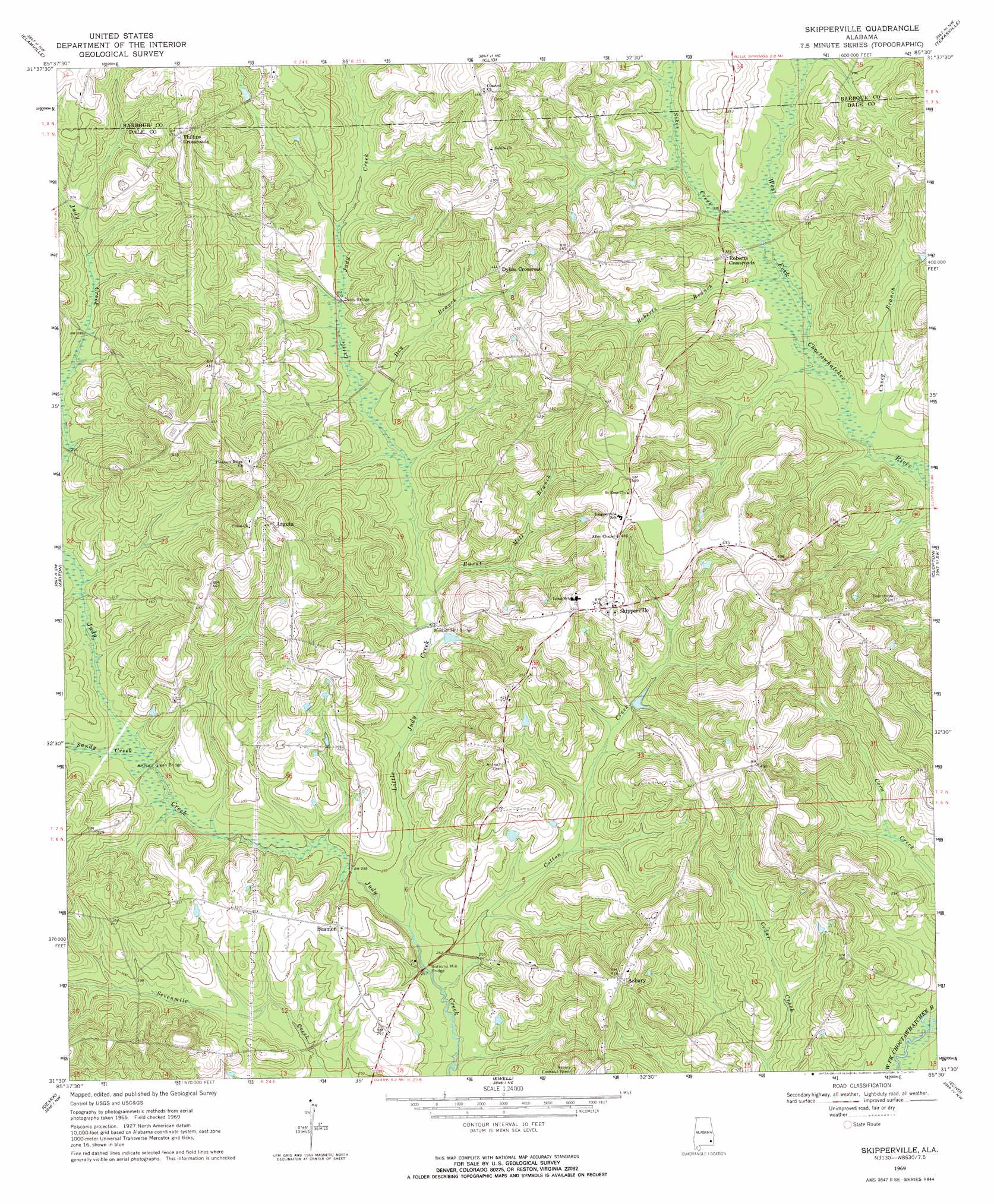
Skipperville Topo Map Alabama
To zoom in, hover over the map of Skipperville
USGS Topo Quad 31085e5 - 1:24,000 scale
| Topo Map Name: | Skipperville |
| USGS Topo Quad ID: | 31085e5 |
| Print Size: | ca. 21 1/4" wide x 27" high |
| Southeast Coordinates: | 31.5° N latitude / 85.5° W longitude |
| Map Center Coordinates: | 31.5625° N latitude / 85.5625° W longitude |
| U.S. State: | AL |
| Filename: | o31085e5.jpg |
| Download Map JPG Image: | Skipperville topo map 1:24,000 scale |
| Map Type: | Topographic |
| Topo Series: | 7.5´ |
| Map Scale: | 1:24,000 |
| Source of Map Images: | United States Geological Survey (USGS) |
| Alternate Map Versions: |
Skipperville AL 1969, updated 1971 Download PDF Buy paper map Skipperville AL 2011 Download PDF Buy paper map Skipperville AL 2014 Download PDF Buy paper map |
1:24,000 Topo Quads surrounding Skipperville
Banks |
Josie |
Louisville |
Clayton South |
Baker Hill |
Brundidge |
Elamville |
Clio |
Texasville |
Lawrenceville |
Brundidge Se |
Ariton |
Skipperville |
Clopton |
Abbeville West |
Enterprise Ne |
Ozark |
Ewell |
Echo |
Newville |
Enterprise |
Daleville |
Pinckard |
Midland City |
Headland |
> Back to 31085e1 at 1:100,000 scale
> Back to 31084a1 at 1:250,000 scale
> Back to U.S. Topo Maps home
Skipperville topo map: Gazetteer
Skipperville: Bridges
Bottoms Mill Bridge elevation 70m 229′Davis Bridge elevation 92m 301′
Dixon Bridge elevation 84m 275′
Glenn Bridge elevation 79m 259′
Metcalf Mill Bridge elevation 82m 269′
Skipperville: Populated Places
Arguta elevation 138m 452′Asbury elevation 128m 419′
Beamon elevation 96m 314′
Dykes Crossroad elevation 135m 442′
Phillips Crossroads elevation 144m 472′
Roberts Crossroads elevation 100m 328′
Skipperville elevation 140m 459′
Skipperville: Post Offices
Skipperville Post Office elevation 138m 452′Skipperville: Streams
Bakey Branch elevation 79m 259′Bordshaw Branch elevation 81m 265′
Burnt Mill Branch elevation 82m 269′
Caney Branch elevation 79m 259′
Cotton Creek elevation 70m 229′
Dry Branch elevation 88m 288′
Little Judy Creek elevation 71m 232′
Roberts Branch elevation 82m 269′
Sandy Creek elevation 80m 262′
Sikes Creek elevation 83m 272′
Skipperville digital topo map on disk
Buy this Skipperville topo map showing relief, roads, GPS coordinates and other geographical features, as a high-resolution digital map file on DVD:
Gulf Coast (LA, MS, AL, FL) & Southwestern Georgia
Buy digital topo maps: Gulf Coast (LA, MS, AL, FL) & Southwestern Georgia
 & Southwestern Georgia map DVD")