Banks Topo Map Alabama
To zoom in, hover over the map of Banks
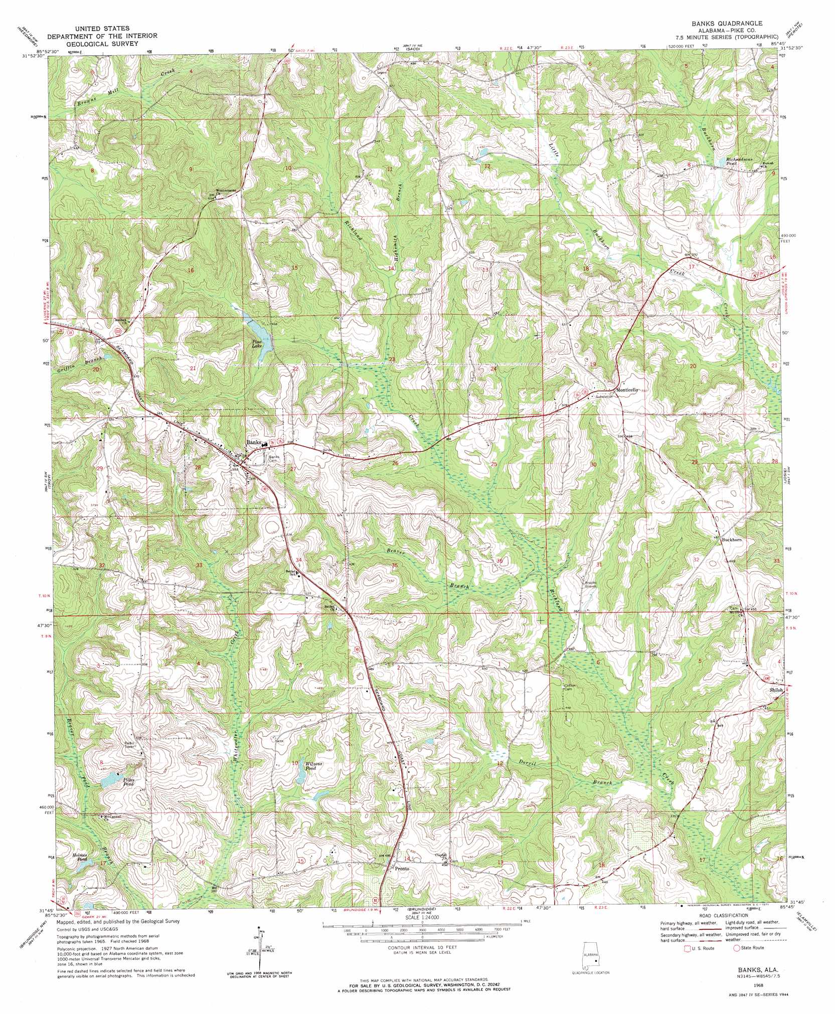
USGS Topo Quad 31085g7 - 1:24,000 scale
| Topo Map Name: | Banks |
| USGS Topo Quad ID: | 31085g7 |
| Print Size: | ca. 21 1/4" wide x 27" high |
| Southeast Coordinates: | 31.75° N latitude / 85.75° W longitude |
| Map Center Coordinates: | 31.8125° N latitude / 85.8125° W longitude |
| U.S. State: | AL |
| Filename: | o31085g7.jpg |
| Download Map JPG Image: | Banks topo map 1:24,000 scale |
| Map Type: | Topographic |
| Topo Series: | 7.5´ |
| Map Scale: | 1:24,000 |
| Source of Map Images: | United States Geological Survey (USGS) |
| Alternate Map Versions: |
Banks AL 1968, updated 1971 Download PDF Buy paper map Banks AL 2011 Download PDF Buy paper map Banks AL 2014 Download PDF Buy paper map |
1:24,000 Topo Quads surrounding Banks
Pine Level |
China Grove |
Almeria |
Aberfoil |
Midway |
Ansley |
Needmore |
Saco |
Perote |
Mount Andrew |
Youngblood |
Troy |
Banks |
Josie |
Louisville |
Goshen |
Brundidge Nw |
Brundidge |
Elamville |
Clio |
Bluff Springs |
Victoria |
Brundidge Se |
Ariton |
Skipperville |
> Back to 31085e1 at 1:100,000 scale
> Back to 31084a1 at 1:250,000 scale
> Back to U.S. Topo Maps home
Banks topo map: Gazetteer
Banks: Dams
Foy Ingram Dam elevation 120m 393′Sorrell Lake Dam elevation 125m 410′
Banks: Populated Places
Banks elevation 169m 554′Buckhorn elevation 149m 488′
Monticello elevation 167m 547′
Pronto elevation 146m 479′
Banks: Post Offices
Banks Post Office elevation 169m 554′Pea River Post Office (historical) elevation 135m 442′
Banks: Reservoirs
Foy Ingram Pond elevation 120m 393′Holmes Pond elevation 112m 367′
Pikes Pond elevation 126m 413′
Pine Lake elevation 128m 419′
Richardsons Pond elevation 112m 367′
Wilsons Pond elevation 117m 383′
Banks: Streams
Beaver Branch elevation 106m 347′Dorril Branch elevation 99m 324′
Highsmith Branch elevation 120m 393′
Little Buckhorn Creek elevation 107m 351′
Banks digital topo map on disk
Buy this Banks topo map showing relief, roads, GPS coordinates and other geographical features, as a high-resolution digital map file on DVD:
Gulf Coast (LA, MS, AL, FL) & Southwestern Georgia
Buy digital topo maps: Gulf Coast (LA, MS, AL, FL) & Southwestern Georgia
 & Southwestern Georgia map DVD")