Sellersville Topo Map Alabama
To zoom in, hover over the map of Sellersville
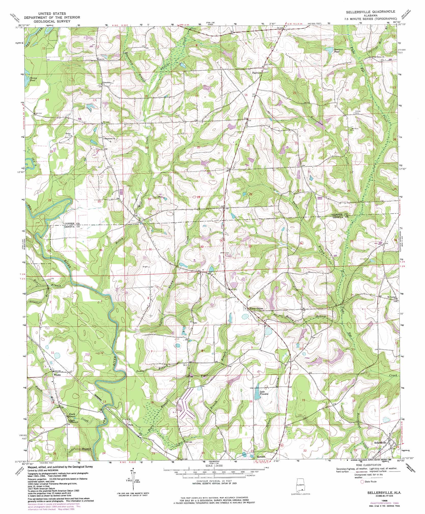
USGS Topo Quad 31086b1 - 1:24,000 scale
| Topo Map Name: | Sellersville |
| USGS Topo Quad ID: | 31086b1 |
| Print Size: | ca. 21 1/4" wide x 27" high |
| Southeast Coordinates: | 31.125° N latitude / 86° W longitude |
| Map Center Coordinates: | 31.1875° N latitude / 86.0625° W longitude |
| U.S. State: | AL |
| Filename: | o31086b1.jpg |
| Download Map JPG Image: | Sellersville topo map 1:24,000 scale |
| Map Type: | Topographic |
| Topo Series: | 7.5´ |
| Map Scale: | 1:24,000 |
| Source of Map Images: | United States Geological Survey (USGS) |
| Alternate Map Versions: |
Sellersville AL 1968, updated 1971 Download PDF Buy paper map Sellersville AL 1968, updated 1986 Download PDF Buy paper map Sellersville AL 2011 Download PDF Buy paper map Sellersville AL 2014 Download PDF Buy paper map |
1:24,000 Topo Quads surrounding Sellersville
Dozier |
Danleys Crossroads |
Elba |
New Brockton |
Enterprise Ne |
Opp West |
Opp East |
Ino |
Goodman |
Enterprise |
Onycha |
Kinston |
Sellersville |
Coffee Springs |
Bellwood |
Florala |
Hacoda |
Samson |
Geneva West |
Geneva East |
Paxton |
Gaskin |
Darlington |
Hobbs Crossroads |
Izagora |
> Back to 31086a1 at 1:100,000 scale
> Back to 31086a1 at 1:250,000 scale
> Back to U.S. Topo Maps home
Sellersville topo map: Gazetteer
Sellersville: Dams
Bowden Sessions Pond Dam elevation 84m 275′E S Brooks Dam elevation 69m 226′
Frank Davis Dam elevation 60m 196′
James Wise Pond Dam Number 1 elevation 86m 282′
James Wise Pond Dam Number 2 elevation 75m 246′
Roland Day Pond Dam elevation 61m 200′
Ted Averett Dam elevation 68m 223′
Sellersville: Lakes
Faulk Millpond elevation 41m 134′Sellersville: Populated Places
Fairview elevation 99m 324′Holley Store elevation 82m 269′
Mount Carmel elevation 72m 236′
Pera elevation 44m 144′
Piney Grove elevation 80m 262′
Sellersville elevation 66m 216′
Weeks elevation 58m 190′
Sellersville: Reservoirs
Frank Davis Lake elevation 60m 196′James Wise Pond elevation 86m 282′
James Wise Pond Number Two elevation 75m 246′
Lake Frankie elevation 68m 223′
Roland Day Pond elevation 61m 200′
Sessions Pond elevation 67m 219′
Ted Averett Lake elevation 68m 223′
Sellersville: Streams
Bear Branch elevation 32m 104′Beaverdam Branch elevation 54m 177′
Beaverdam Creek elevation 50m 164′
Bee Branch elevation 42m 137′
Cedar Branch elevation 33m 108′
Faulk Mill Creek elevation 32m 104′
Holley Branch elevation 45m 147′
Holley Mill Creek elevation 32m 104′
Little Rocky Creek elevation 32m 104′
Lowery Creek elevation 45m 147′
Palmer Branch elevation 46m 150′
Phillips Creek elevation 54m 177′
Phillips Mill Branch elevation 62m 203′
Pond Branch elevation 68m 223′
Roundabout Creek elevation 42m 137′
Snake Branch elevation 33m 108′
Soapstone Branch elevation 45m 147′
Tiger Branch elevation 32m 104′
Whisky Branch elevation 56m 183′
Sellersville digital topo map on disk
Buy this Sellersville topo map showing relief, roads, GPS coordinates and other geographical features, as a high-resolution digital map file on DVD:
Gulf Coast (LA, MS, AL, FL) & Southwestern Georgia
Buy digital topo maps: Gulf Coast (LA, MS, AL, FL) & Southwestern Georgia
 & Southwestern Georgia map DVD")