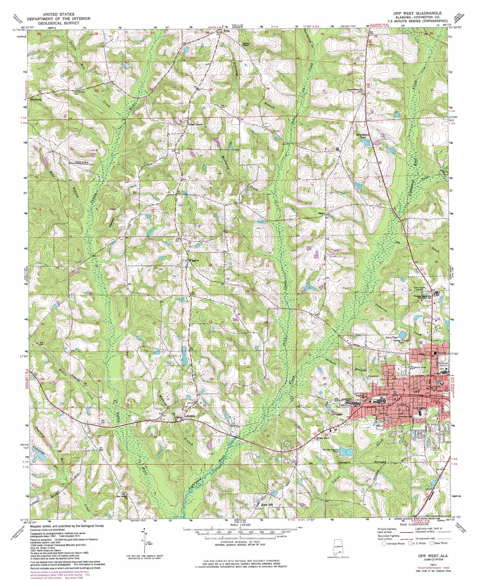
Opp West Topo Map Alabama
To zoom in, hover over the map of Opp West
USGS Topo Quad 31086c3 - 1:24,000 scale
| Topo Map Name: | Opp West |
| USGS Topo Quad ID: | 31086c3 |
| Print Size: | ca. 21 1/4" wide x 27" high |
| Southeast Coordinates: | 31.25° N latitude / 86.25° W longitude |
| Map Center Coordinates: | 31.3125° N latitude / 86.3125° W longitude |
| U.S. State: | AL |
| Filename: | o31086c3.jpg |
| Download Map JPG Image: | Opp West topo map 1:24,000 scale |
| Map Type: | Topographic |
| Topo Series: | 7.5´ |
| Map Scale: | 1:24,000 |
| Source of Map Images: | United States Geological Survey (USGS) |
| Alternate Map Versions: |
Opp West AL 1971, updated 1973 Download PDF Buy paper map Opp West AL 1971, updated 1986 Download PDF Buy paper map Opp West AL 2011 Download PDF Buy paper map Opp West AL 2014 Download PDF Buy paper map |
1:24,000 Topo Quads surrounding Opp West
Industry |
Leon |
Brantley |
Bullock |
Bluff Springs |
Red Level |
Gantt |
Dozier |
Danleys Crossroads |
Elba |
River Falls |
Andalusia |
Opp West |
Opp East |
Ino |
Carolina |
Libertyville |
Onycha |
Kinston |
Sellersville |
Wing |
Watkins Bridge |
Florala |
Hacoda |
Samson |
> Back to 31086a1 at 1:100,000 scale
> Back to 31086a1 at 1:250,000 scale
> Back to U.S. Topo Maps home
Opp West topo map: Gazetteer
Opp West: Parks
Channell-Lee Stadium elevation 90m 295′W F Jackson State Park elevation 68m 223′
Opp West: Populated Places
Babbie elevation 78m 255′Cedar Grove elevation 105m 344′
Eoda elevation 122m 400′
Harmony elevation 114m 374′
Opine elevation 103m 337′
Opp elevation 103m 337′
Wiggins elevation 96m 314′
Opp West: Post Offices
Opp Post Office elevation 101m 331′Opp West: Reservoirs
Donaldson Pond elevation 89m 291′Opp West: Streams
Anderson Branch elevation 64m 209′Bear Branch elevation 73m 239′
Cameron Creek elevation 67m 219′
Gin Creek elevation 69m 226′
Good Springs Creek elevation 88m 288′
Hollis Creek elevation 63m 206′
Holloway Branch elevation 78m 255′
Meeting House Branch elevation 59m 193′
Mulberry Creek elevation 72m 236′
Pitman Branch elevation 65m 213′
Poley Creek elevation 64m 209′
Pond Creek elevation 71m 232′
Sasser Branch elevation 71m 232′
Tervin Mill Creek elevation 77m 252′
Opp West digital topo map on disk
Buy this Opp West topo map showing relief, roads, GPS coordinates and other geographical features, as a high-resolution digital map file on DVD:
Gulf Coast (LA, MS, AL, FL) & Southwestern Georgia
Buy digital topo maps: Gulf Coast (LA, MS, AL, FL) & Southwestern Georgia
 & Southwestern Georgia map DVD")