Ansley Topo Map Alabama
To zoom in, hover over the map of Ansley
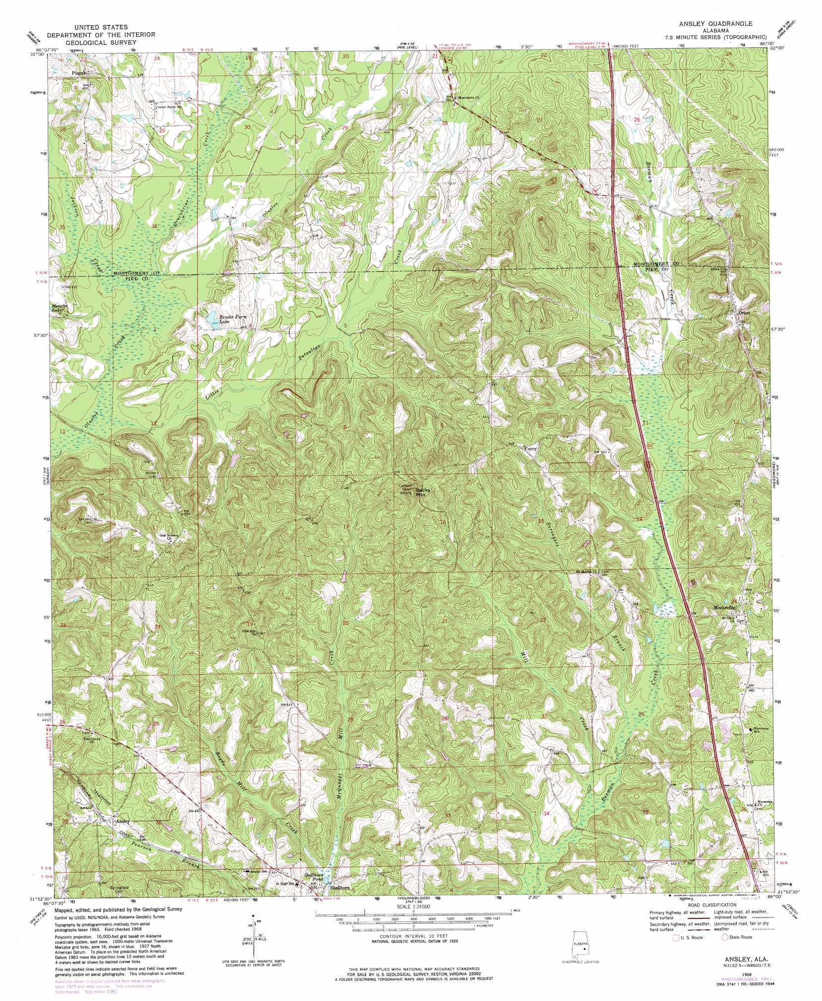
USGS Topo Quad 31086h1 - 1:24,000 scale
| Topo Map Name: | Ansley |
| USGS Topo Quad ID: | 31086h1 |
| Print Size: | ca. 21 1/4" wide x 27" high |
| Southeast Coordinates: | 31.875° N latitude / 86° W longitude |
| Map Center Coordinates: | 31.9375° N latitude / 86.0625° W longitude |
| U.S. State: | AL |
| Filename: | o31086h1.jpg |
| Download Map JPG Image: | Ansley topo map 1:24,000 scale |
| Map Type: | Topographic |
| Topo Series: | 7.5´ |
| Map Scale: | 1:24,000 |
| Source of Map Images: | United States Geological Survey (USGS) |
| Alternate Map Versions: |
Ansley AL 1968, updated 1971 Download PDF Buy paper map Ansley AL 1968, updated 1981 Download PDF Buy paper map Ansley AL 2011 Download PDF Buy paper map Ansley AL 2014 Download PDF Buy paper map |
1:24,000 Topo Quads surrounding Ansley
Snowdoun |
Davis Crossroads |
Teasleys Mill |
Fitzpatrick |
Thompson |
Sellers |
Ramer |
Pine Level |
China Grove |
Almeria |
Lapine |
Grady |
Ansley |
Needmore |
Saco |
Fullers Crossroads |
Petrey |
Youngblood |
Troy |
Banks |
Luverne |
Glenwood |
Goshen |
Brundidge Nw |
Brundidge |
> Back to 31086e1 at 1:100,000 scale
> Back to 31086a1 at 1:250,000 scale
> Back to U.S. Topo Maps home
Ansley topo map: Gazetteer
Ansley: Lakes
Shellhorn Pond elevation 112m 367′Ansley: Populated Places
Ansley elevation 135m 442′Center Point elevation 127m 416′
Curry elevation 159m 521′
Friendship elevation 135m 442′
Meeksville elevation 148m 485′
Orion elevation 171m 561′
Pisgah elevation 150m 492′
Shellhorn elevation 125m 410′
Ansley: Reservoirs
Brooks Farm Lake elevation 121m 396′Menefee Lake elevation 123m 403′
Ansley: Streams
Greenbrier Creek elevation 112m 367′Jackson Creek elevation 111m 364′
Little Patsaliga Creek elevation 109m 357′
McQuagge Mill Creek elevation 112m 367′
Mill Creek elevation 105m 344′
Surveyors Branch elevation 108m 354′
Ansley: Summits
Becks Mountain elevation 205m 672′Ansley digital topo map on disk
Buy this Ansley topo map showing relief, roads, GPS coordinates and other geographical features, as a high-resolution digital map file on DVD:
Gulf Coast (LA, MS, AL, FL) & Southwestern Georgia
Buy digital topo maps: Gulf Coast (LA, MS, AL, FL) & Southwestern Georgia
 & Southwestern Georgia map DVD")