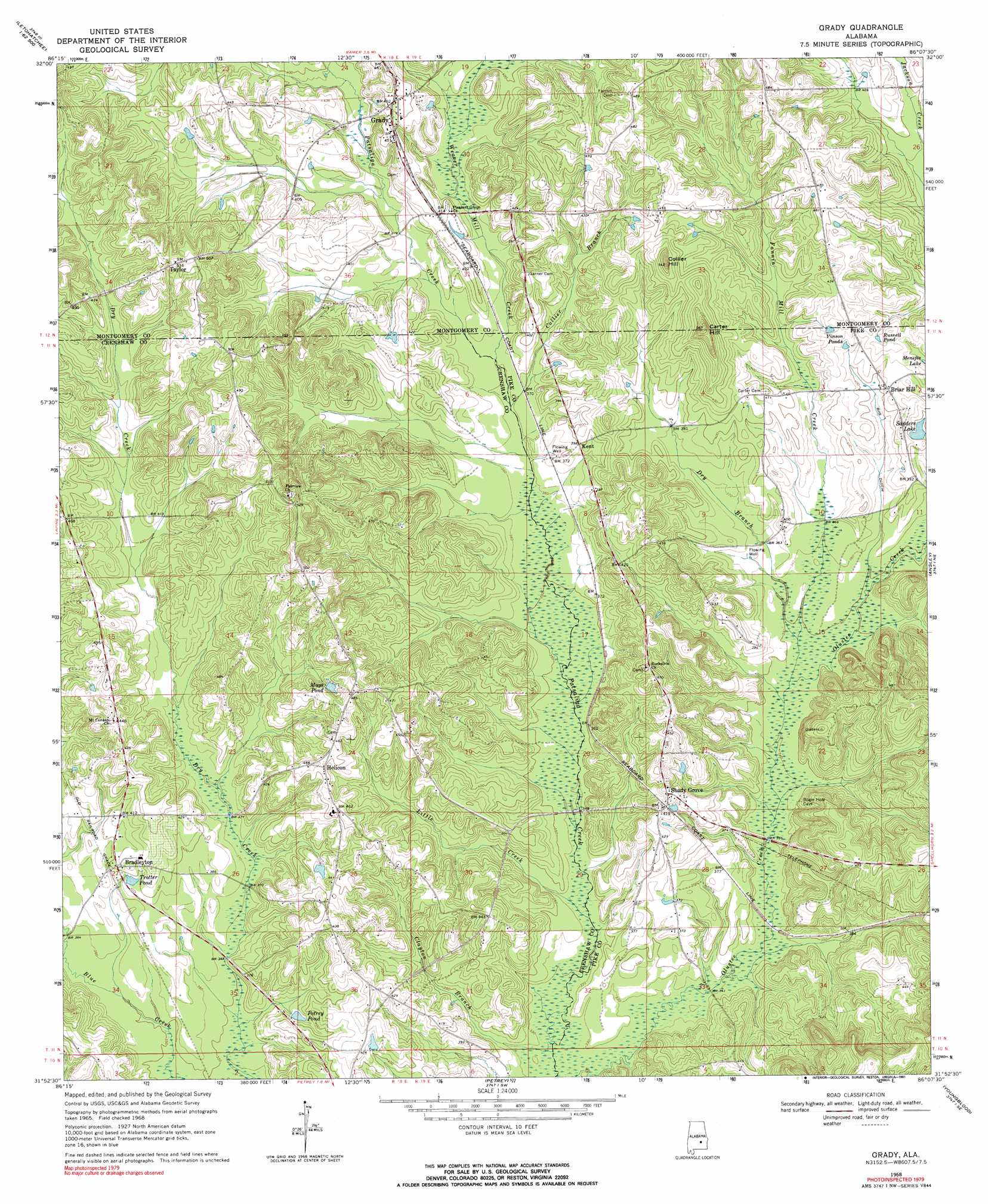
Grady Topo Map Alabama
To zoom in, hover over the map of Grady
USGS Topo Quad 31086h2 - 1:24,000 scale
| Topo Map Name: | Grady |
| USGS Topo Quad ID: | 31086h2 |
| Print Size: | ca. 21 1/4" wide x 27" high |
| Southeast Coordinates: | 31.875° N latitude / 86.125° W longitude |
| Map Center Coordinates: | 31.9375° N latitude / 86.1875° W longitude |
| U.S. State: | AL |
| Filename: | o31086h2.jpg |
| Download Map JPG Image: | Grady topo map 1:24,000 scale |
| Map Type: | Topographic |
| Topo Series: | 7.5´ |
| Map Scale: | 1:24,000 |
| Source of Map Images: | United States Geological Survey (USGS) |
| Alternate Map Versions: |
Grady AL 1968, updated 1971 Download PDF Buy paper map Grady AL 1968, updated 1991 Download PDF Buy paper map Grady AL 2011 Download PDF Buy paper map Grady AL 2014 Download PDF Buy paper map |
1:24,000 Topo Quads surrounding Grady
Letohatchee |
Snowdoun |
Davis Crossroads |
Teasleys Mill |
Fitzpatrick |
Sandy Ridge |
Sellers |
Ramer |
Pine Level |
China Grove |
Danielsville |
Lapine |
Grady |
Ansley |
Needmore |
Honoraville |
Fullers Crossroads |
Petrey |
Youngblood |
Troy |
Moodys Crossroads |
Luverne |
Glenwood |
Goshen |
Brundidge Nw |
> Back to 31086e1 at 1:100,000 scale
> Back to 31086a1 at 1:250,000 scale
> Back to U.S. Topo Maps home
Grady topo map: Gazetteer
Grady: Bridges
Kent Bridge (historical) elevation 108m 354′Salter Bridge elevation 109m 357′
Grady: Populated Places
Bradleyton elevation 124m 406′Briar Hill elevation 125m 410′
Grady elevation 139m 456′
Helicon elevation 138m 452′
Kent elevation 121m 396′
Olustee elevation 125m 410′
Shady Grove elevation 132m 433′
Taylor elevation 157m 515′
Grady: Post Offices
Bradleyton Post Office (historical) elevation 123m 403′Chesser Post Office (historical) elevation 131m 429′
Grady: Reservoirs
Mays Pond elevation 136m 446′Petrey Pond elevation 114m 374′
Russell Pond elevation 129m 423′
Sanders Lake elevation 119m 390′
Trotter Pond elevation 120m 393′
Vinson Ponds elevation 129m 423′
Grady: Streams
Clayton Branch elevation 100m 328′Collier Branch elevation 109m 357′
Dry Branch elevation 106m 347′
Fannin Mill Creek elevation 105m 344′
Little Creek elevation 101m 331′
Tucker Creek elevation 120m 393′
Weaver Mill Creek elevation 110m 360′
Grady: Summits
Carter Hill elevation 169m 554′Collier Hill elevation 160m 524′
Grady digital topo map on disk
Buy this Grady topo map showing relief, roads, GPS coordinates and other geographical features, as a high-resolution digital map file on DVD:
Gulf Coast (LA, MS, AL, FL) & Southwestern Georgia
Buy digital topo maps: Gulf Coast (LA, MS, AL, FL) & Southwestern Georgia
 & Southwestern Georgia map DVD")