Pine Apple North Topo Map Alabama
To zoom in, hover over the map of Pine Apple North
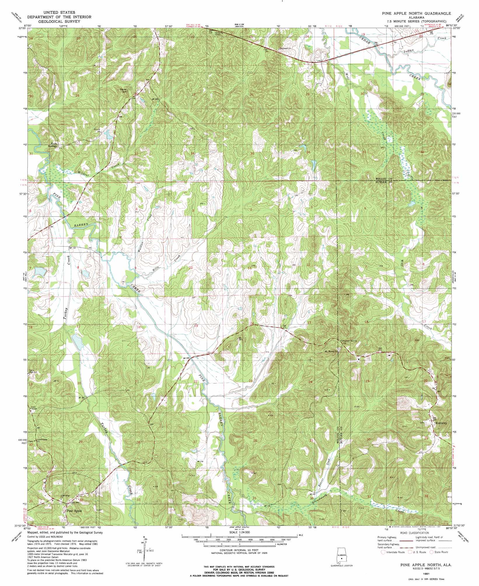
USGS Topo Quad 31086h8 - 1:24,000 scale
| Topo Map Name: | Pine Apple North |
| USGS Topo Quad ID: | 31086h8 |
| Print Size: | ca. 21 1/4" wide x 27" high |
| Southeast Coordinates: | 31.875° N latitude / 86.875° W longitude |
| Map Center Coordinates: | 31.9375° N latitude / 86.9375° W longitude |
| U.S. State: | AL |
| Filename: | o31086h8.jpg |
| Download Map JPG Image: | Pine Apple North topo map 1:24,000 scale |
| Map Type: | Topographic |
| Topo Series: | 7.5´ |
| Map Scale: | 1:24,000 |
| Source of Map Images: | United States Geological Survey (USGS) |
| Alternate Map Versions: |
Pine Apple North AL 1981, updated 1981 Download PDF Buy paper map Pine Apple North AL 2011 Download PDF Buy paper map Pine Apple North AL 2014 Download PDF Buy paper map |
1:24,000 Topo Quads surrounding Pine Apple North
Tasso |
Elm Bluff |
Pleasant Hill |
Collirene |
Gordonsville |
Tilden |
Carlowville |
Minter |
Braggs |
Mount Willing |
Rosebud |
Oak Hill |
Pine Apple North |
Ridgeville |
Fort Dale |
Nadawah |
Mcwilliams |
Pine Apple South |
Forest Home |
Greenville West |
Beatrice |
Skinnerton |
Bethel |
Georgiana West |
Georgiana East |
> Back to 31086e1 at 1:100,000 scale
> Back to 31086a1 at 1:250,000 scale
> Back to U.S. Topo Maps home
Pine Apple North topo map: Gazetteer
Pine Apple North: Dams
Copeland Dam elevation 65m 213′E G Donald Lake Dam elevation 60m 196′
Thurston Adams Dam elevation 55m 180′
Pine Apple North: Populated Places
Harmony elevation 117m 383′Monterey elevation 134m 439′
Mount Moriah elevation 122m 400′
Rock Springs elevation 65m 213′
Pine Apple North: Post Offices
Mount Moriah Post Office (historical) elevation 125m 410′Womacks Post Office (historical) elevation 68m 223′
Pine Apple North: Reservoirs
Copelands Pond elevation 65m 213′Donald Lake elevation 60m 196′
Thurston Adams Pond elevation 55m 180′
Pine Apple North: Streams
Beaver Creek elevation 69m 226′Brestwork Creek elevation 73m 239′
Hills Creek elevation 55m 180′
Indian Creek elevation 54m 177′
Turkey Creek elevation 52m 170′
Wardlaw Creek elevation 54m 177′
Wildcat Creek elevation 49m 160′
Wolf Creek elevation 55m 180′
Pine Apple North digital topo map on disk
Buy this Pine Apple North topo map showing relief, roads, GPS coordinates and other geographical features, as a high-resolution digital map file on DVD:
Gulf Coast (LA, MS, AL, FL) & Southwestern Georgia
Buy digital topo maps: Gulf Coast (LA, MS, AL, FL) & Southwestern Georgia
 & Southwestern Georgia map DVD")