Barnett Crossroads Topo Map Alabama
To zoom in, hover over the map of Barnett Crossroads
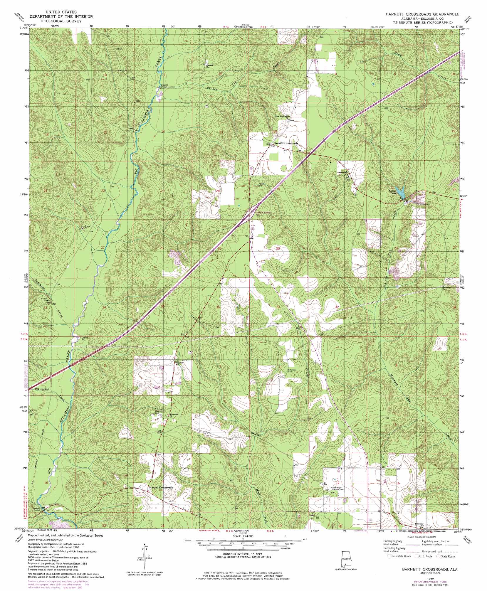
USGS Topo Quad 31087b3 - 1:24,000 scale
| Topo Map Name: | Barnett Crossroads |
| USGS Topo Quad ID: | 31087b3 |
| Print Size: | ca. 21 1/4" wide x 27" high |
| Southeast Coordinates: | 31.125° N latitude / 87.25° W longitude |
| Map Center Coordinates: | 31.1875° N latitude / 87.3125° W longitude |
| U.S. State: | AL |
| Filename: | o31087b3.jpg |
| Download Map JPG Image: | Barnett Crossroads topo map 1:24,000 scale |
| Map Type: | Topographic |
| Topo Series: | 7.5´ |
| Map Scale: | 1:24,000 |
| Source of Map Images: | United States Geological Survey (USGS) |
| Alternate Map Versions: |
Barnett Crossroads AL 1960, updated 1961 Download PDF Buy paper map Barnett Crossroads AL 1960, updated 1981 Download PDF Buy paper map Barnett Crossroads AL 1960, updated 1986 Download PDF Buy paper map Barnett Crossroads AL 2011 Download PDF Buy paper map Barnett Crossroads AL 2014 Download PDF Buy paper map |
1:24,000 Topo Quads surrounding Barnett Crossroads
Flynns Lake |
Frisco City |
Excel |
Repton |
Belleville |
Uriah West |
Uriah East |
Frisco City Se |
Range |
Castleberry |
Mccullough |
Huxford |
Barnett Crossroads |
Wallace |
Brewton North |
Freemanville |
Atmore |
Flomaton |
Pollard |
Brewton South |
Walnut Hill |
Bratt |
Century |
Jay |
Fidelis |
> Back to 31087a1 at 1:100,000 scale
> Back to 31086a1 at 1:250,000 scale
> Back to U.S. Topo Maps home
Barnett Crossroads topo map: Gazetteer
Barnett Crossroads: Bridges
Gressett Bridge elevation 47m 154′Sardine Bridge elevation 33m 108′
Barnett Crossroads: Crossings
Interchange 69 elevation 105m 344′Barnett Crossroads: Populated Places
Barnett Crossroads elevation 108m 354′Pineview elevation 93m 305′
Sardine elevation 37m 121′
Stanley Crossroads elevation 96m 314′
Barnett Crossroads: Reservoirs
Kellys Lake elevation 73m 239′Barnett Crossroads: Streams
Big Spring Creek elevation 37m 121′Broken Leg Creek elevation 47m 154′
Robinson Creek elevation 40m 131′
Barnett Crossroads digital topo map on disk
Buy this Barnett Crossroads topo map showing relief, roads, GPS coordinates and other geographical features, as a high-resolution digital map file on DVD:
Gulf Coast (LA, MS, AL, FL) & Southwestern Georgia
Buy digital topo maps: Gulf Coast (LA, MS, AL, FL) & Southwestern Georgia
 & Southwestern Georgia map DVD")