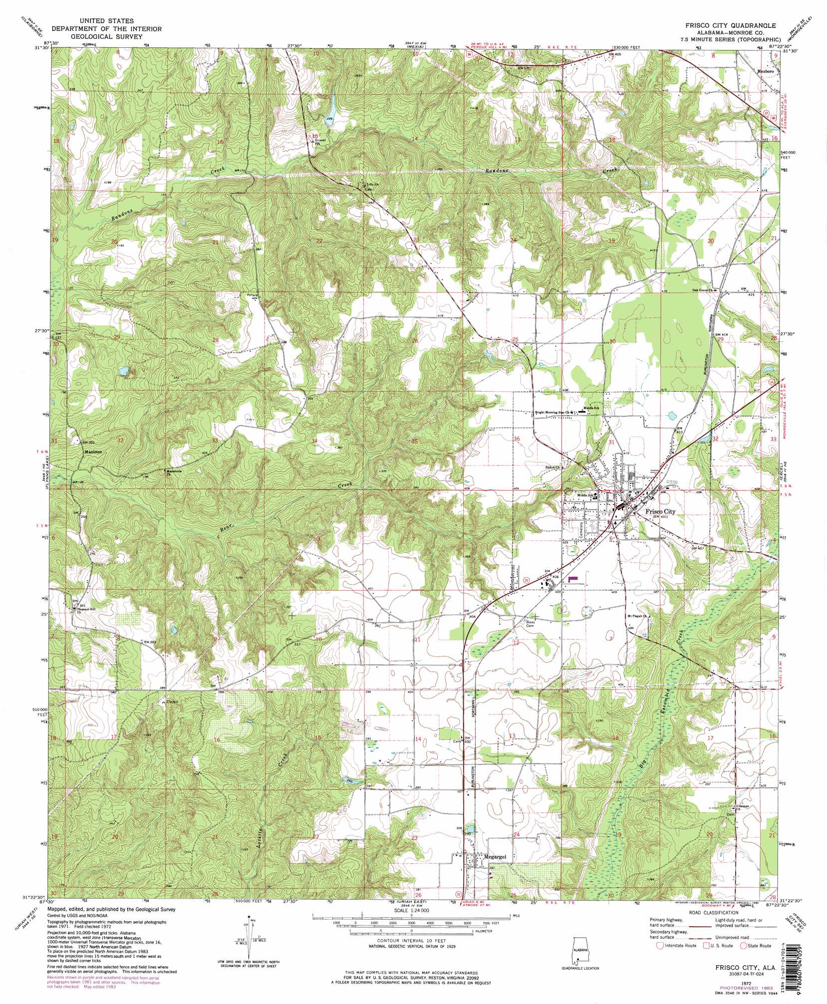
Frisco City Topo Map Alabama
To zoom in, hover over the map of Frisco City
USGS Topo Quad 31087d4 - 1:24,000 scale
| Topo Map Name: | Frisco City |
| USGS Topo Quad ID: | 31087d4 |
| Print Size: | ca. 21 1/4" wide x 27" high |
| Southeast Coordinates: | 31.375° N latitude / 87.375° W longitude |
| Map Center Coordinates: | 31.4375° N latitude / 87.4375° W longitude |
| U.S. State: | AL |
| Filename: | o31087d4.jpg |
| Download Map JPG Image: | Frisco City topo map 1:24,000 scale |
| Map Type: | Topographic |
| Topo Series: | 7.5´ |
| Map Scale: | 1:24,000 |
| Source of Map Images: | United States Geological Survey (USGS) |
| Alternate Map Versions: |
Frisco City AL 1972, updated 1973 Download PDF Buy paper map Frisco City AL 1972, updated 1984 Download PDF Buy paper map Frisco City AL 1972, updated 1984 Download PDF Buy paper map Frisco City AL 2011 Download PDF Buy paper map Frisco City AL 2014 Download PDF Buy paper map |
1:24,000 Topo Quads surrounding Frisco City
Whatley |
Chance |
Franklin |
Natchez |
Beatrice |
Suggsville |
Claiborne |
Mexia |
Monroeville |
Burnt Corn |
Gainestown |
Flynns Lake |
Frisco City |
Excel |
Repton |
Chrysler |
Uriah West |
Uriah East |
Frisco City Se |
Range |
Blacksher |
Mccullough |
Huxford |
Barnett Crossroads |
Wallace |
> Back to 31087a1 at 1:100,000 scale
> Back to 31086a1 at 1:250,000 scale
> Back to U.S. Topo Maps home
Frisco City topo map: Gazetteer
Frisco City: Dams
Bert Boroughs Pond Dam elevation 66m 216′Frisco City: Lakes
Moores Pond elevation 55m 180′Negro Pond (historical) elevation 57m 187′
Frisco City: Oilfields
Frisco City Oil Field elevation 118m 387′Frisco City: Populated Places
Frisco City elevation 123m 403′Manistee elevation 51m 167′
Megargel elevation 119m 390′
Frisco City: Reservoirs
Boroughs Pond elevation 66m 216′Frisco City digital topo map on disk
Buy this Frisco City topo map showing relief, roads, GPS coordinates and other geographical features, as a high-resolution digital map file on DVD:
Gulf Coast (LA, MS, AL, FL) & Southwestern Georgia
Buy digital topo maps: Gulf Coast (LA, MS, AL, FL) & Southwestern Georgia
 & Southwestern Georgia map DVD")