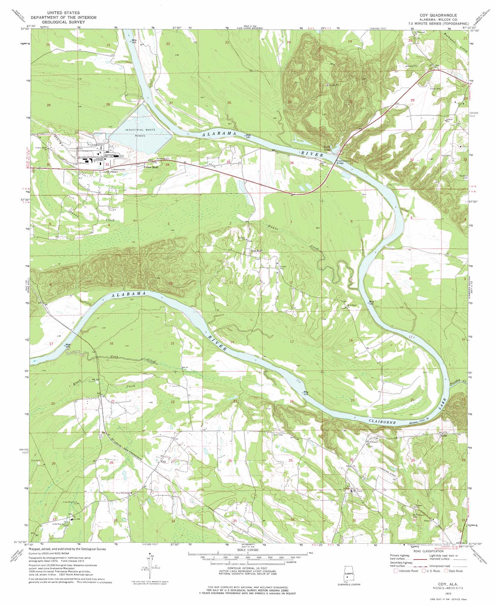
Coy Topo Map Alabama
To zoom in, hover over the map of Coy
USGS Topo Quad 31087h4 - 1:24,000 scale
| Topo Map Name: | Coy |
| USGS Topo Quad ID: | 31087h4 |
| Print Size: | ca. 21 1/4" wide x 27" high |
| Southeast Coordinates: | 31.875° N latitude / 87.375° W longitude |
| Map Center Coordinates: | 31.9375° N latitude / 87.4375° W longitude |
| U.S. State: | AL |
| Filename: | o31087h4.jpg |
| Download Map JPG Image: | Coy topo map 1:24,000 scale |
| Map Type: | Topographic |
| Topo Series: | 7.5´ |
| Map Scale: | 1:24,000 |
| Source of Map Images: | United States Geological Survey (USGS) |
| Alternate Map Versions: |
Coy AL 1973, updated 1977 Download PDF Buy paper map Coy AL 2011 Download PDF Buy paper map Coy AL 2014 Download PDF Buy paper map |
1:24,000 Topo Quads surrounding Coy
Magnolia |
Flatwood |
Catherine |
Crumptonia |
Tasso |
Surginer |
Kimbrough |
Lee Long Bridge |
Camden North |
Tilden |
Thomasville |
Pine Hill |
Coy |
Camden South |
Rosebud |
Fulton East |
Lower Peach Tree |
Hybart |
Vredenburgh |
Nadawah |
Whatley |
Chance |
Franklin |
Natchez |
Beatrice |
> Back to 31087e1 at 1:100,000 scale
> Back to 31086a1 at 1:250,000 scale
> Back to U.S. Topo Maps home
Coy topo map: Gazetteer
Coy: Bars
Evans Lower Bar elevation 11m 36′Evans Upper Bar elevation 11m 36′
Matthews Bar elevation 11m 36′
McNeils Bar elevation 11m 36′
Reeves Bar elevation 11m 36′
Tait Bar elevation 11m 36′
Wilcox Bar elevation 11m 36′
Yellow Jacket Bar elevation 11m 36′
Coy: Bridges
Frank Dobson Bridge elevation 11m 36′Coy: Cliffs
Black Bluff elevation 23m 75′Gullett Bluff elevation 53m 173′
Walnut Bluff elevation 21m 68′
Coy: Crossings
Holly Ferry (historical) elevation 11m 36′Coy: Dams
Brox Mcintosh Dam elevation 44m 144′S E Ryals Dam elevation 21m 68′
Coy: Islands
Hobbs Island elevation 13m 42′Tait Island elevation 12m 39′
Coy: Lakes
Lake Glen elevation 17m 55′Coy: Parks
Gulletts Bluff Park elevation 62m 203′Holleys Ferry Access Point Park elevation 29m 95′
Coy: Populated Places
Coal Bluff elevation 36m 118′Coy elevation 29m 95′
Nellie elevation 64m 209′
Sheppard elevation 22m 72′
Yellow Bluff elevation 31m 101′
Coy: Post Offices
Coy Post Office elevation 27m 88′Coy: Reservoirs
Brox Mcintosh Lake elevation 44m 144′MacMillan Bloedel Incorporated Waste Pond elevation 22m 72′
Ryals Lake elevation 21m 68′
Coy: Streams
Dunns Creek elevation 14m 45′Grey Creek elevation 12m 39′
Pursley Creek elevation 12m 39′
Coy digital topo map on disk
Buy this Coy topo map showing relief, roads, GPS coordinates and other geographical features, as a high-resolution digital map file on DVD:
Gulf Coast (LA, MS, AL, FL) & Southwestern Georgia
Buy digital topo maps: Gulf Coast (LA, MS, AL, FL) & Southwestern Georgia
 & Southwestern Georgia map DVD")