Mount Vernon Topo Map Alabama
To zoom in, hover over the map of Mount Vernon
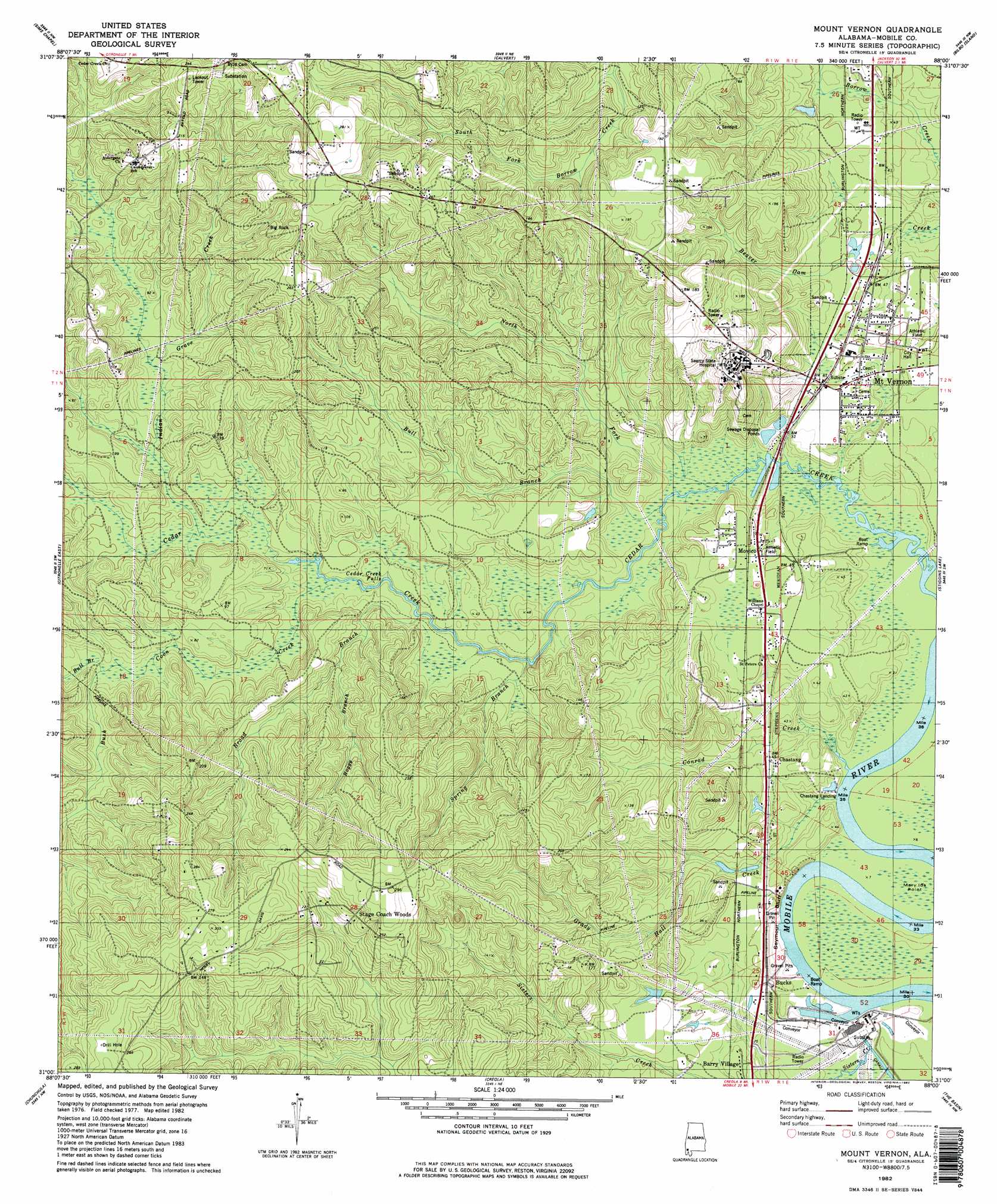
USGS Topo Quad 31088a1 - 1:24,000 scale
| Topo Map Name: | Mount Vernon |
| USGS Topo Quad ID: | 31088a1 |
| Print Size: | ca. 21 1/4" wide x 27" high |
| Southeast Coordinates: | 31° N latitude / 88° W longitude |
| Map Center Coordinates: | 31.0625° N latitude / 88.0625° W longitude |
| U.S. State: | AL |
| Filename: | o31088a1.jpg |
| Download Map JPG Image: | Mount Vernon topo map 1:24,000 scale |
| Map Type: | Topographic |
| Topo Series: | 7.5´ |
| Map Scale: | 1:24,000 |
| Source of Map Images: | United States Geological Survey (USGS) |
| Alternate Map Versions: |
Mount Vernon AL 1982, updated 1982 Download PDF Buy paper map Mount Vernon AL 1982, updated 1982 Download PDF Buy paper map Mount Vernon AL 2011 Download PDF Buy paper map Mount Vernon AL 2014 Download PDF Buy paper map |
1:24,000 Topo Quads surrounding Mount Vernon
Vinegar Bend |
Seaboard |
Mcintosh |
Gin House Island |
Carlton |
Deer Park |
Sims Chapel |
Calvert |
Bilbo Island |
Tensaw |
Citronelle West |
Citronelle East |
Mount Vernon |
Stiggins Lake |
Vaughn |
Georgetown |
Chunchula |
Creola |
The Basin |
Bay Minette North |
Semmes |
Kushla |
Chickasaw |
Hurricane |
Bay Minette South |
> Back to 31088a1 at 1:100,000 scale
> Back to 31088a1 at 1:250,000 scale
> Back to U.S. Topo Maps home
Mount Vernon topo map: Gazetteer
Mount Vernon: Cliffs
Chastang Bluff elevation 6m 19′Seymour Bluff elevation 3m 9′
Thirty One Mile Bluff elevation 3m 9′
Thirty Seven Mile Bluff elevation 5m 16′
Mount Vernon: Falls
Cedar Creek Falls elevation 5m 16′Mount Vernon: Populated Places
Bucks elevation 13m 42′Chastang elevation 13m 42′
Mount Vernon elevation 11m 36′
Movico elevation 16m 52′
Pineola elevation 33m 108′
Stage Coach Woods elevation 65m 213′
Mount Vernon: Streams
Boggy Branch elevation 15m 49′Broad Branch elevation 5m 16′
Bull Branch elevation 3m 9′
Bull Branch elevation 17m 55′
Bush Coon Creek elevation 7m 22′
Conrad Creek elevation 2m 6′
Grady Hall Creek elevation 1m 3′
Indian Grave Creek elevation 11m 36′
North Fork Cedar Creek elevation 3m 9′
Spring Branch elevation 6m 19′
Mount Vernon: Summits
Big Rock elevation 63m 206′Mount Vernon digital topo map on disk
Buy this Mount Vernon topo map showing relief, roads, GPS coordinates and other geographical features, as a high-resolution digital map file on DVD:
Gulf Coast (LA, MS, AL, FL) & Southwestern Georgia
Buy digital topo maps: Gulf Coast (LA, MS, AL, FL) & Southwestern Georgia
 & Southwestern Georgia map DVD")