Leakesville Sw Topo Map Mississippi
To zoom in, hover over the map of Leakesville Sw
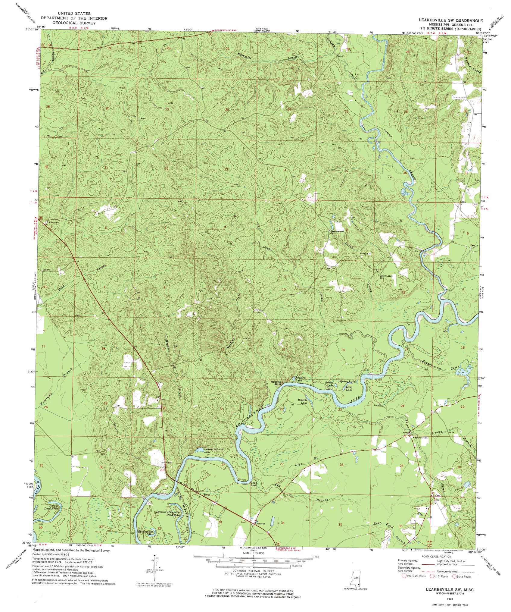
USGS Topo Quad 31088a6 - 1:24,000 scale
| Topo Map Name: | Leakesville Sw |
| USGS Topo Quad ID: | 31088a6 |
| Print Size: | ca. 21 1/4" wide x 27" high |
| Southeast Coordinates: | 31° N latitude / 88.625° W longitude |
| Map Center Coordinates: | 31.0625° N latitude / 88.6875° W longitude |
| U.S. State: | MS |
| Filename: | o31088a6.jpg |
| Download Map JPG Image: | Leakesville Sw topo map 1:24,000 scale |
| Map Type: | Topographic |
| Topo Series: | 7.5´ |
| Map Scale: | 1:24,000 |
| Source of Map Images: | United States Geological Survey (USGS) |
| Alternate Map Versions: |
Leakesville SW MS 1973, updated 1975 Download PDF Buy paper map Leakesville SW MS 1973, updated 1975 Download PDF Buy paper map Leakesville SW MS 2012 Download PDF Buy paper map Leakesville SW MS 2015 Download PDF Buy paper map |
1:24,000 Topo Quads surrounding Leakesville Sw
Richton |
Brewer |
Avera |
Clark |
Fruitdale |
Beaumont |
Neely |
Jonathan |
Leakesville |
Rounsaville |
Taylor Hill |
Mclain |
Leakesville Sw |
Vernal |
Brown Town |
Barbara |
Avent |
Merrill |
Lucedale |
Earlville |
Ramsey Springs |
Benndale |
Basin |
Agricola |
Howell |
> Back to 31088a1 at 1:100,000 scale
> Back to 31088a1 at 1:250,000 scale
> Back to U.S. Topo Maps home
Leakesville Sw topo map: Gazetteer
Leakesville Sw: Bridges
Miller Bridge elevation 17m 55′Leakesville Sw: Cliffs
Roberts Bluff elevation 21m 68′Shell Bluff elevation 15m 49′
Leakesville Sw: Crossings
Colemans Ferry (historical) elevation 12m 39′Leakesville Sw: Lakes
Colonel Merrill Lake elevation 13m 42′Cowans Dead River elevation 15m 49′
Dressler Hammond Dead River elevation 15m 49′
Long Lake elevation 15m 49′
Rattlesnake Lake elevation 15m 49′
Redbird Lake elevation 15m 49′
Roberts Lake elevation 15m 49′
Round Lake elevation 15m 49′
Spring Lake elevation 16m 52′
Leakesville Sw: Post Offices
McManus Post Office (historical) elevation 48m 157′Leakesville Sw: Streams
Ard Branch elevation 13m 42′Bear Pond Branch elevation 21m 68′
Big Creek elevation 12m 39′
Brushy Creek elevation 20m 65′
Conn Creek elevation 14m 45′
Denny Branch elevation 18m 59′
Evans Creek elevation 12m 39′
Gatling Creek elevation 12m 39′
Hammill Creek elevation 23m 75′
Hogan Creek elevation 11m 36′
Lige Branch elevation 15m 49′
Little Creek elevation 18m 59′
McInnis Creek elevation 11m 36′
Skinner Creek elevation 12m 39′
Leakesville Sw digital topo map on disk
Buy this Leakesville Sw topo map showing relief, roads, GPS coordinates and other geographical features, as a high-resolution digital map file on DVD:
Gulf Coast (LA, MS, AL, FL) & Southwestern Georgia
Buy digital topo maps: Gulf Coast (LA, MS, AL, FL) & Southwestern Georgia
 & Southwestern Georgia map DVD")