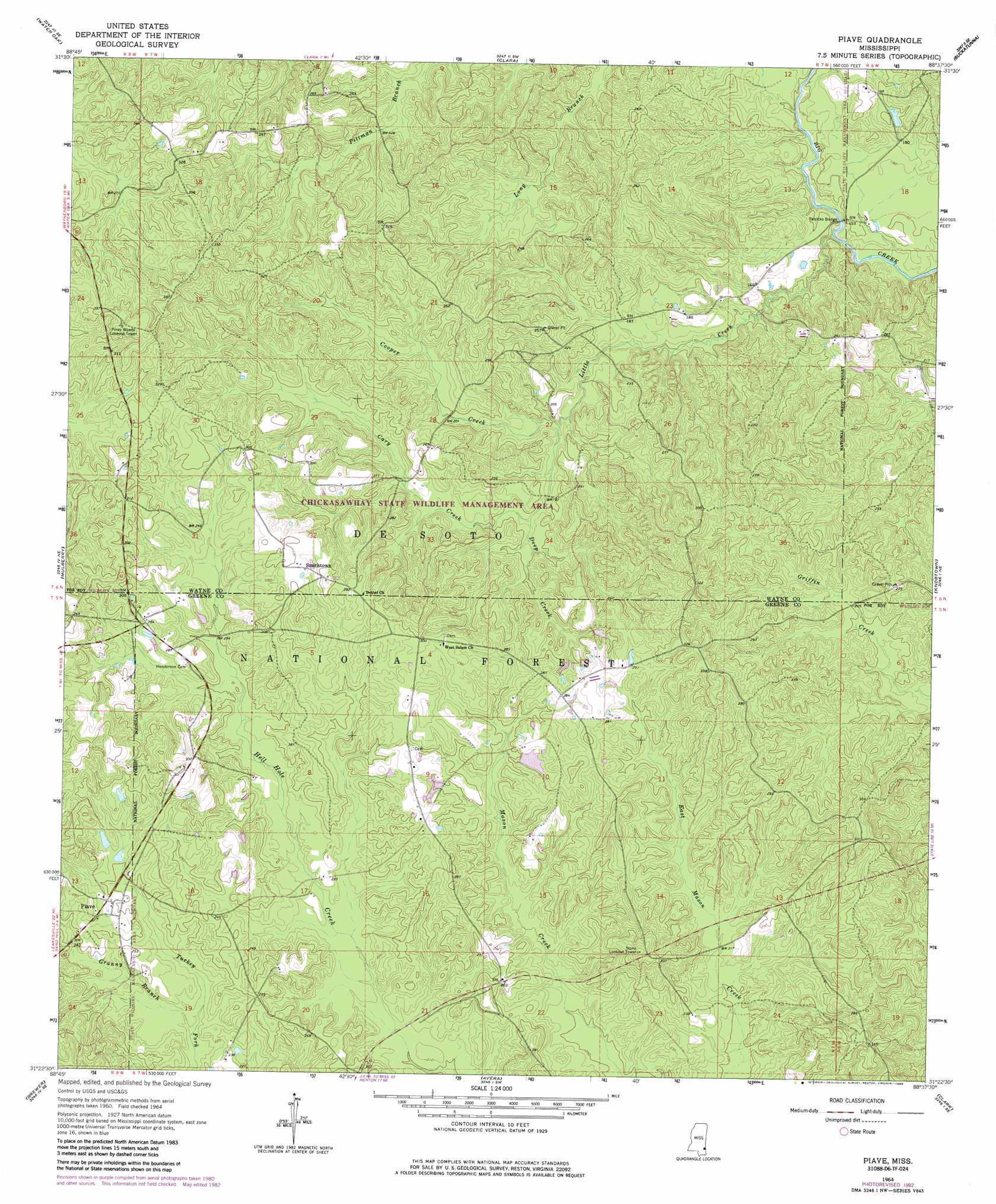
Piave Topo Map Mississippi
To zoom in, hover over the map of Piave
USGS Topo Quad 31088d6 - 1:24,000 scale
| Topo Map Name: | Piave |
| USGS Topo Quad ID: | 31088d6 |
| Print Size: | ca. 21 1/4" wide x 27" high |
| Southeast Coordinates: | 31.375° N latitude / 88.625° W longitude |
| Map Center Coordinates: | 31.4375° N latitude / 88.6875° W longitude |
| U.S. State: | MS |
| Filename: | o31088d6.jpg |
| Download Map JPG Image: | Piave topo map 1:24,000 scale |
| Map Type: | Topographic |
| Topo Series: | 7.5´ |
| Map Scale: | 1:24,000 |
| Source of Map Images: | United States Geological Survey (USGS) |
| Alternate Map Versions: |
Piave MS 1964, updated 1965 Download PDF Buy paper map Piave MS 1964, updated 1976 Download PDF Buy paper map Piave MS 1964, updated 1982 Download PDF Buy paper map Piave MS 1964, updated 1986 Download PDF Buy paper map Piave MS 2000, updated 2002 Download PDF Buy paper map Piave MS 2012 Download PDF Buy paper map Piave MS 2015 Download PDF Buy paper map |
| FStopo: | US Forest Service topo Piave is available: Download FStopo PDF Download FStopo TIF |
1:24,000 Topo Quads surrounding Piave
Myrick |
Whistler |
Waynesboro |
Denham |
Aquilla |
Strengthford |
Water Oak |
Clara |
Buckatunna |
Copeland |
Rhodes |
Mulberry |
Piave |
Knobtown |
State Line |
Richton |
Brewer |
Avera |
Clark |
Fruitdale |
Beaumont |
Neely |
Jonathan |
Leakesville |
Rounsaville |
> Back to 31088a1 at 1:100,000 scale
> Back to 31088a1 at 1:250,000 scale
> Back to U.S. Topo Maps home
Piave topo map: Gazetteer
Piave: Bridges
Patricks Bridge elevation 39m 127′Piave: Dams
H D Brewer Lake Dam elevation 80m 262′Piave: Populated Places
Piave elevation 83m 272′Smithtown elevation 90m 295′
Piave: Streams
Cary Creek elevation 52m 170′Cooper Creek elevation 52m 170′
Deep Creek elevation 57m 187′
Granny Branch elevation 63m 206′
Little Creek elevation 39m 127′
Piave digital topo map on disk
Buy this Piave topo map showing relief, roads, GPS coordinates and other geographical features, as a high-resolution digital map file on DVD:
Gulf Coast (LA, MS, AL, FL) & Southwestern Georgia
Buy digital topo maps: Gulf Coast (LA, MS, AL, FL) & Southwestern Georgia
 & Southwestern Georgia map DVD")