Mulberry Topo Map Mississippi
To zoom in, hover over the map of Mulberry
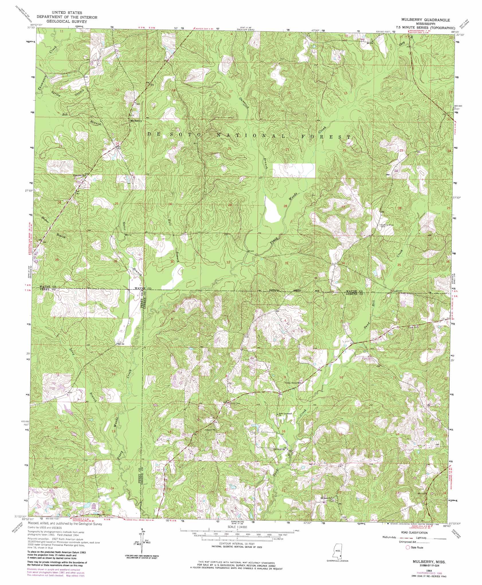
USGS Topo Quad 31088d7 - 1:24,000 scale
| Topo Map Name: | Mulberry |
| USGS Topo Quad ID: | 31088d7 |
| Print Size: | ca. 21 1/4" wide x 27" high |
| Southeast Coordinates: | 31.375° N latitude / 88.75° W longitude |
| Map Center Coordinates: | 31.4375° N latitude / 88.8125° W longitude |
| U.S. State: | MS |
| Filename: | o31088d7.jpg |
| Download Map JPG Image: | Mulberry topo map 1:24,000 scale |
| Map Type: | Topographic |
| Topo Series: | 7.5´ |
| Map Scale: | 1:24,000 |
| Source of Map Images: | United States Geological Survey (USGS) |
| Alternate Map Versions: |
Mulberry MS 1964, updated 1965 Download PDF Buy paper map Mulberry MS 1964, updated 1982 Download PDF Buy paper map Mulberry MS 1964, updated 1985 Download PDF Buy paper map Mulberry MS 2000, updated 2002 Download PDF Buy paper map Mulberry MS 2012 Download PDF Buy paper map Mulberry MS 2015 Download PDF Buy paper map |
| FStopo: | US Forest Service topo Mulberry is available: Download FStopo PDF Download FStopo TIF |
1:24,000 Topo Quads surrounding Mulberry
Laurel East |
Myrick |
Whistler |
Waynesboro |
Denham |
Lanham |
Strengthford |
Water Oak |
Clara |
Buckatunna |
Ovett |
Rhodes |
Mulberry |
Piave |
Knobtown |
Ovett Se |
Richton |
Brewer |
Avera |
Clark |
New Augusta |
Beaumont |
Neely |
Jonathan |
Leakesville |
> Back to 31088a1 at 1:100,000 scale
> Back to 31088a1 at 1:250,000 scale
> Back to U.S. Topo Maps home
Mulberry topo map: Gazetteer
Mulberry: Dams
J R Stinson Lake Dam elevation 68m 223′Mohlenoff Pond Dam elevation 65m 213′
Mulberry: Populated Places
Henderson elevation 92m 301′Mulberry elevation 79m 259′
Mulberry: Streams
Gator Branch elevation 55m 180′Gunstock Branch elevation 58m 190′
Hall Branch elevation 54m 177′
Okey Branch elevation 74m 242′
Spring Branch elevation 52m 170′
Mulberry digital topo map on disk
Buy this Mulberry topo map showing relief, roads, GPS coordinates and other geographical features, as a high-resolution digital map file on DVD:
Gulf Coast (LA, MS, AL, FL) & Southwestern Georgia
Buy digital topo maps: Gulf Coast (LA, MS, AL, FL) & Southwestern Georgia
 & Southwestern Georgia map DVD")