Buckatunna Topo Map Mississippi
To zoom in, hover over the map of Buckatunna
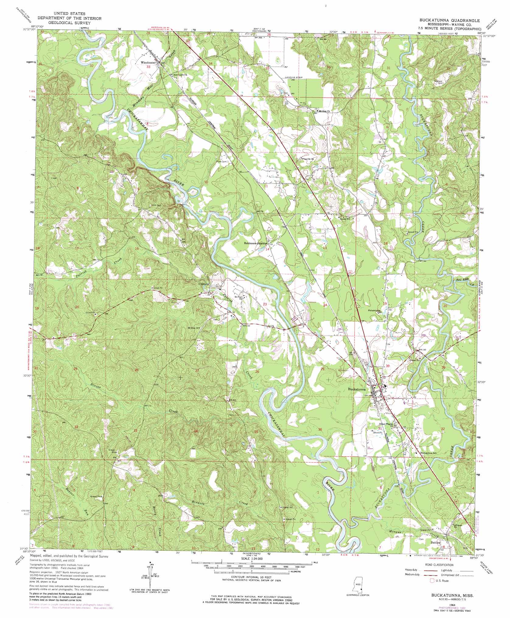
USGS Topo Quad 31088e5 - 1:24,000 scale
| Topo Map Name: | Buckatunna |
| USGS Topo Quad ID: | 31088e5 |
| Print Size: | ca. 21 1/4" wide x 27" high |
| Southeast Coordinates: | 31.5° N latitude / 88.5° W longitude |
| Map Center Coordinates: | 31.5625° N latitude / 88.5625° W longitude |
| U.S. State: | MS |
| Filename: | o31088e5.jpg |
| Download Map JPG Image: | Buckatunna topo map 1:24,000 scale |
| Map Type: | Topographic |
| Topo Series: | 7.5´ |
| Map Scale: | 1:24,000 |
| Source of Map Images: | United States Geological Survey (USGS) |
| Alternate Map Versions: |
Buckatunna MS 1964, updated 1965 Download PDF Buy paper map Buckatunna MS 1964, updated 1976 Download PDF Buy paper map Buckatunna MS 1964, updated 1982 Download PDF Buy paper map Buckatunna MS 2012 Download PDF Buy paper map Buckatunna MS 2015 Download PDF Buy paper map |
1:24,000 Topo Quads surrounding Buckatunna
Eucutta |
Shubuta |
Matherville |
Isney |
Silas |
Whistler |
Waynesboro |
Denham |
Aquilla |
Millry North |
Water Oak |
Clara |
Buckatunna |
Copeland |
Millry South |
Mulberry |
Piave |
Knobtown |
State Line |
Chatom |
Brewer |
Avera |
Clark |
Fruitdale |
Vinegar Bend |
> Back to 31088e1 at 1:100,000 scale
> Back to 31088a1 at 1:250,000 scale
> Back to U.S. Topo Maps home
Buckatunna topo map: Gazetteer
Buckatunna: Crossings
Pattons Ferry (historical) elevation 42m 137′Poes Ferry (historical) elevation 31m 101′
Buckatunna: Lakes
Meadows Mill Pond (historical) elevation 46m 150′Buckatunna: Populated Places
Battles elevation 45m 147′Buckatunna elevation 46m 150′
Chicora elevation 47m 154′
Robinsons Junction elevation 46m 150′
Winchester elevation 50m 164′
Buckatunna: Streams
Beaver Creek elevation 33m 108′Big Red Creek elevation 35m 114′
Buckatunna Creek elevation 30m 98′
Meadows Mill Creek elevation 36m 118′
Mongus Creek elevation 32m 104′
Patrick Creek elevation 34m 111′
Buckatunna digital topo map on disk
Buy this Buckatunna topo map showing relief, roads, GPS coordinates and other geographical features, as a high-resolution digital map file on DVD:
Gulf Coast (LA, MS, AL, FL) & Southwestern Georgia
Buy digital topo maps: Gulf Coast (LA, MS, AL, FL) & Southwestern Georgia
 & Southwestern Georgia map DVD")