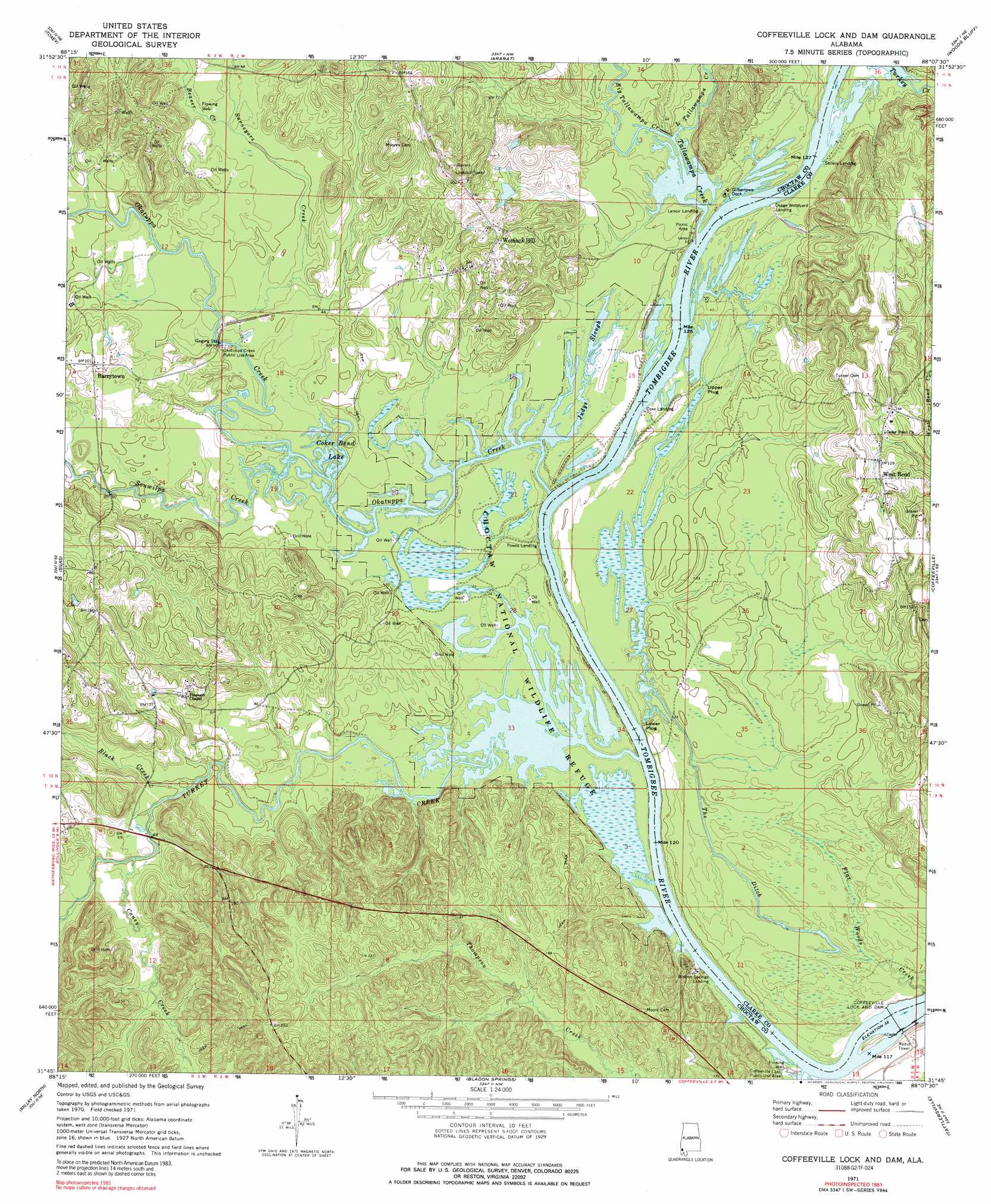
Coffeeville Lock And Dam Topo Map Alabama
To zoom in, hover over the map of Coffeeville Lock And Dam
USGS Topo Quad 31088g2 - 1:24,000 scale
| Topo Map Name: | Coffeeville Lock And Dam |
| USGS Topo Quad ID: | 31088g2 |
| Print Size: | ca. 21 1/4" wide x 27" high |
| Southeast Coordinates: | 31.75° N latitude / 88.125° W longitude |
| Map Center Coordinates: | 31.8125° N latitude / 88.1875° W longitude |
| U.S. State: | AL |
| Filename: | o31088g2.jpg |
| Download Map JPG Image: | Coffeeville Lock And Dam topo map 1:24,000 scale |
| Map Type: | Topographic |
| Topo Series: | 7.5´ |
| Map Scale: | 1:24,000 |
| Source of Map Images: | United States Geological Survey (USGS) |
| Alternate Map Versions: |
Coffeeville Lock And Dam AL 1971, updated 1975 Download PDF Buy paper map Coffeeville Lock And Dam AL 1971, updated 1989 Download PDF Buy paper map Coffeeville Lock And Dam AL 2011 Download PDF Buy paper map Coffeeville Lock And Dam AL 2014 Download PDF Buy paper map |
1:24,000 Topo Quads surrounding Coffeeville Lock And Dam
Hinton |
Land |
Butler |
Putnam |
Nanafalia |
Melvin |
Toxey |
Ararat |
Woods Bluff |
Morvin |
Isney |
Silas |
Coffeeville Lock And Dam |
Coffeeville |
Mcentyre |
Aquilla |
Millry North |
Bladon Springs |
Tattlersville |
Winn |
Copeland |
Millry South |
Bigbee |
Saint Stephens |
Jackson |
> Back to 31088e1 at 1:100,000 scale
> Back to 31088a1 at 1:250,000 scale
> Back to U.S. Topo Maps home
Coffeeville Lock And Dam topo map: Gazetteer
Coffeeville Lock And Dam: Bars
Osage Bar elevation 10m 32′Philans Shoal elevation 10m 32′
Sellers Bar elevation 10m 32′
Thompsons Shoal elevation 10m 32′
Turner Shoals elevation 10m 32′
Coffeeville Lock And Dam: Bends
Goose Neck Bend elevation 12m 39′Coffeeville Lock And Dam: Cliffs
McGregor Bluff elevation 34m 111′Secession Bluff elevation 29m 95′
Coffeeville Lock And Dam: Dams
Coffeeville Lock and Dam elevation 7m 22′Lower Plug elevation 15m 49′
Upper Plug elevation 11m 36′
Coffeeville Lock And Dam: Guts
Judys Slough elevation 10m 32′The Ditch elevation 9m 29′
Coffeeville Lock And Dam: Lakes
Coker Bend Lake elevation 10m 32′Coffeeville Lock And Dam: Oilfields
Barrytown Oil Field elevation 14m 45′South Womack Hill Oil Field elevation 24m 78′
Turkey Creek Oil Field elevation 11m 36′
West Bend Oil Field elevation 15m 49′
Womack Hill Oil Field elevation 10m 32′
Coffeeville Lock And Dam: Parks
Choctaw National Wildlife Refuge elevation 10m 32′Coffeeville Lake Public Use Area elevation 15m 49′
Okatuppa Creek Public Use Area elevation 13m 42′
Coffeeville Lock And Dam: Populated Places
Fakit Chipunta (historical) elevation 16m 52′Flatwood elevation 42m 137′
West Bend elevation 41m 134′
Womack Hill elevation 33m 108′
Coffeeville Lock And Dam: Reservoirs
Coffeeville Lake elevation 7m 22′Coffeeville Lock And Dam: Streams
Beaver Creek elevation 17m 55′Big Tallawampa Creek elevation 10m 32′
Black Creek elevation 12m 39′
Caney Creek elevation 14m 45′
Little Tallawampa Creek elevation 10m 32′
McNish Branch elevation 12m 39′
Mill Creek elevation 21m 68′
Okatuppa Creek elevation 10m 32′
Okatuppa Creek elevation 10m 32′
Souwilpa Creek elevation 10m 32′
Surveyors Creek elevation 12m 39′
Tallawampa Creek elevation 10m 32′
Turkey Creek elevation 10m 32′
Coffeeville Lock And Dam digital topo map on disk
Buy this Coffeeville Lock And Dam topo map showing relief, roads, GPS coordinates and other geographical features, as a high-resolution digital map file on DVD:
Gulf Coast (LA, MS, AL, FL) & Southwestern Georgia
Buy digital topo maps: Gulf Coast (LA, MS, AL, FL) & Southwestern Georgia
 & Southwestern Georgia map DVD")