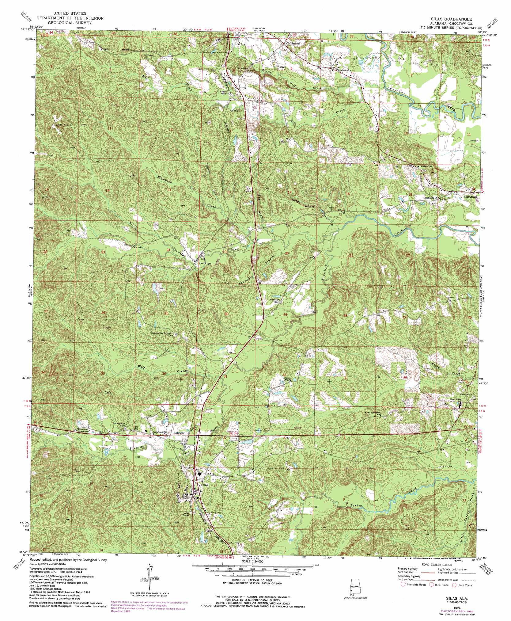
Silas Topo Map Alabama
To zoom in, hover over the map of Silas
USGS Topo Quad 31088g3 - 1:24,000 scale
| Topo Map Name: | Silas |
| USGS Topo Quad ID: | 31088g3 |
| Print Size: | ca. 21 1/4" wide x 27" high |
| Southeast Coordinates: | 31.75° N latitude / 88.25° W longitude |
| Map Center Coordinates: | 31.8125° N latitude / 88.3125° W longitude |
| U.S. State: | AL |
| Filename: | o31088g3.jpg |
| Download Map JPG Image: | Silas topo map 1:24,000 scale |
| Map Type: | Topographic |
| Topo Series: | 7.5´ |
| Map Scale: | 1:24,000 |
| Source of Map Images: | United States Geological Survey (USGS) |
| Alternate Map Versions: |
Silas AL 1974, updated 1977 Download PDF Buy paper map Silas AL 1974, updated 1987 Download PDF Buy paper map Silas AL 2011 Download PDF Buy paper map Silas AL 2014 Download PDF Buy paper map |
1:24,000 Topo Quads surrounding Silas
Sykes |
Hinton |
Land |
Butler |
Putnam |
Carmichael |
Melvin |
Toxey |
Ararat |
Woods Bluff |
Matherville |
Isney |
Silas |
Coffeeville Lock And Dam |
Coffeeville |
Denham |
Aquilla |
Millry North |
Bladon Springs |
Tattlersville |
Buckatunna |
Copeland |
Millry South |
Bigbee |
Saint Stephens |
> Back to 31088e1 at 1:100,000 scale
> Back to 31088a1 at 1:250,000 scale
> Back to U.S. Topo Maps home
Silas topo map: Gazetteer
Silas: Bridges
Nix Bridge (historical) elevation 12m 39′Silas: Oilfields
Gilbertown Oil Field elevation 21m 68′Little Mill Creek Oil Field elevation 38m 124′
Mill Creek Oil Field elevation 48m 157′
Southwest Barrytown Oil Field elevation 36m 118′
West Barrytown Oil Field elevation 27m 88′
Silas: Populated Places
Barrytown elevation 34m 111′Bolinger elevation 55m 180′
Old Samuel elevation 46m 150′
Silas elevation 74m 242′
Souwilpa elevation 38m 124′
Silas: Streams
Beaver Run elevation 34m 111′Big Branch elevation 25m 82′
Coleman Branch elevation 18m 59′
Doty House Branch elevation 21m 68′
Golden Horn Branch elevation 14m 45′
Little Mill Creek elevation 17m 55′
Little Souwilpa Creek elevation 21m 68′
Little Turkey Creek elevation 18m 59′
Mill Branch elevation 23m 75′
Mill Creek elevation 16m 52′
Pine Branch elevation 56m 183′
Rocky Branch elevation 25m 82′
Shumaker Branch elevation 26m 85′
Thompson Creek elevation 29m 95′
Wolf Creek elevation 42m 137′
Silas digital topo map on disk
Buy this Silas topo map showing relief, roads, GPS coordinates and other geographical features, as a high-resolution digital map file on DVD:
Gulf Coast (LA, MS, AL, FL) & Southwestern Georgia
Buy digital topo maps: Gulf Coast (LA, MS, AL, FL) & Southwestern Georgia
 & Southwestern Georgia map DVD")