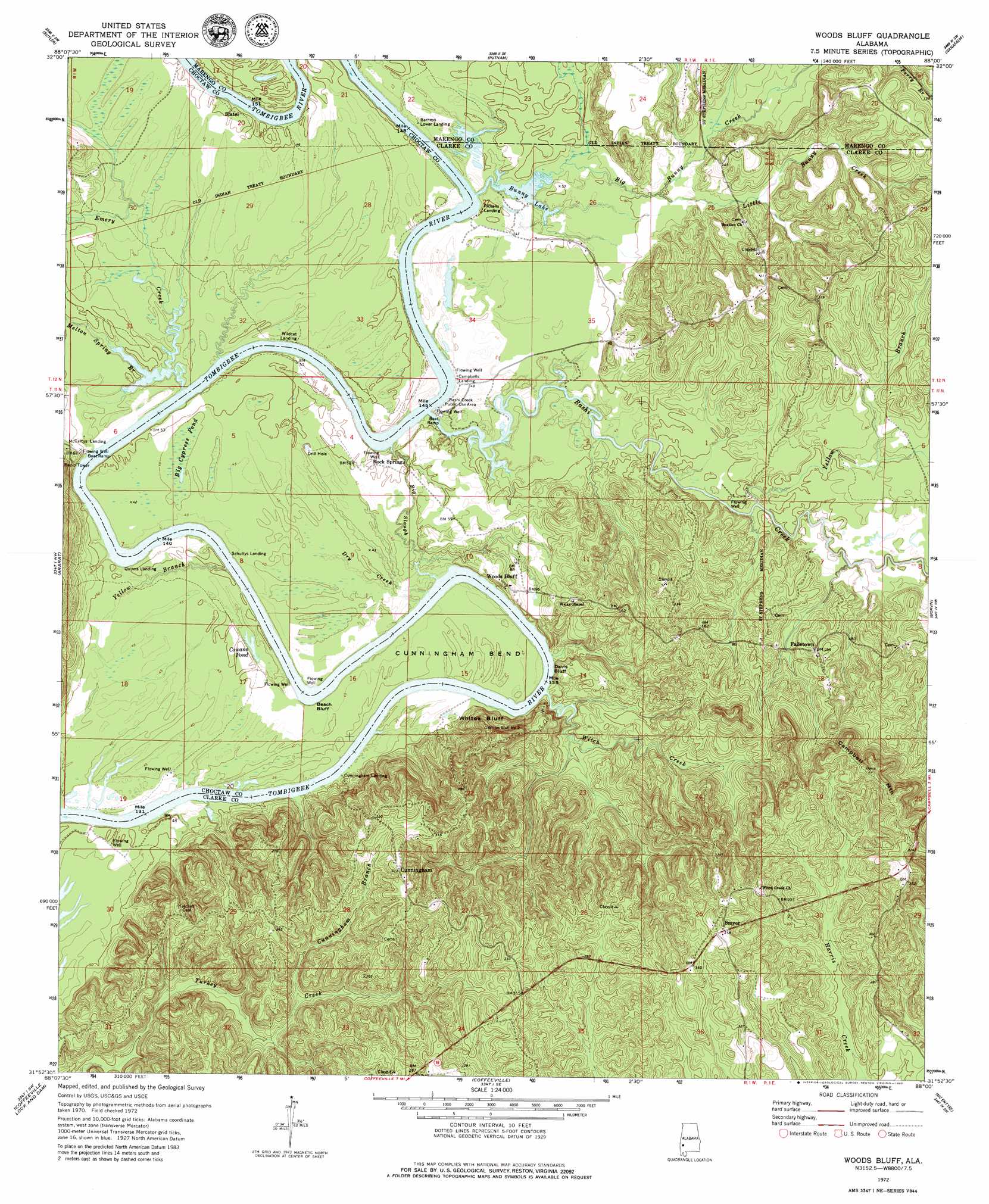
Woods Bluff Topo Map Alabama
To zoom in, hover over the map of Woods Bluff
USGS Topo Quad 31088h1 - 1:24,000 scale
| Topo Map Name: | Woods Bluff |
| USGS Topo Quad ID: | 31088h1 |
| Print Size: | ca. 21 1/4" wide x 27" high |
| Southeast Coordinates: | 31.875° N latitude / 88° W longitude |
| Map Center Coordinates: | 31.9375° N latitude / 88.0625° W longitude |
| U.S. State: | AL |
| Filename: | o31088h1.jpg |
| Download Map JPG Image: | Woods Bluff topo map 1:24,000 scale |
| Map Type: | Topographic |
| Topo Series: | 7.5´ |
| Map Scale: | 1:24,000 |
| Source of Map Images: | United States Geological Survey (USGS) |
| Alternate Map Versions: |
Woods Bluff AL 1972, updated 1975 Download PDF Buy paper map Woods Bluff AL 1972, updated 1980 Download PDF Buy paper map Woods Bluff AL 2011 Download PDF Buy paper map Woods Bluff AL 2014 Download PDF Buy paper map |
1:24,000 Topo Quads surrounding Woods Bluff
Lisman |
Jachin |
Pennington |
Myrtlewood South |
Miller |
Land |
Butler |
Putnam |
Nanafalia |
Sweet Water |
Toxey |
Ararat |
Woods Bluff |
Morvin |
Bashi |
Silas |
Coffeeville Lock And Dam |
Coffeeville |
Mcentyre |
Fulton West |
Millry North |
Bladon Springs |
Tattlersville |
Winn |
Grove Hill |
> Back to 31088e1 at 1:100,000 scale
> Back to 31088a1 at 1:250,000 scale
> Back to U.S. Topo Maps home
Woods Bluff topo map: Gazetteer
Woods Bluff: Bars
Barneys Shoals elevation 14m 45′Cade Bar elevation 10m 32′
Grangers Bar elevation 10m 32′
Woods Bluff Shoal elevation 10m 32′
Woods Bluff: Bends
Cade Bend elevation 14m 45′Cunningham Bend elevation 12m 39′
Woods Bluff: Cliffs
Beach Bluff elevation 11m 36′Davis Bluff elevation 10m 32′
McCartys Bluff elevation 10m 32′
Whites Bluff elevation 41m 134′
Woods Bluff elevation 11m 36′
Yellow Bluff elevation 13m 42′
Woods Bluff: Crossings
McCartys Ferry (historical) elevation 18m 59′Woods Bluff: Lakes
Bunny Lake elevation 10m 32′Cowans Pond elevation 11m 36′
Woods Bluff: Parks
Bashi Creek Public Use Area elevation 14m 45′Woods Bluff Public Use Area elevation 23m 75′
Woods Bluff: Populated Places
Cunningham elevation 96m 314′Failetown elevation 45m 147′
McNeiders (historical) elevation 63m 206′
Rock Springs elevation 15m 49′
Slater elevation 17m 55′
Smyer elevation 109m 357′
Woods Bluff elevation 20m 65′
Woods Bluff: Streams
Bashi Creek elevation 10m 32′Big Bunny Creek elevation 10m 32′
Big Slough elevation 10m 32′
Buttonwood Branch elevation 13m 42′
Cunningham Branch elevation 35m 114′
Dry Creek elevation 11m 36′
Emery Creek elevation 10m 32′
Ferrell Branch elevation 15m 49′
Little Bunny Creek elevation 15m 49′
Melton Spring Branch elevation 10m 32′
Rocky Branch elevation 10m 32′
Witch Creek elevation 10m 32′
Yellow Branch elevation 12m 39′
Yellow Branch elevation 12m 39′
Woods Bluff: Summits
Campbell Mountain elevation 123m 403′Woods Bluff: Swamps
Big Cypress Pond elevation 13m 42′Woods Bluff digital topo map on disk
Buy this Woods Bluff topo map showing relief, roads, GPS coordinates and other geographical features, as a high-resolution digital map file on DVD:
Gulf Coast (LA, MS, AL, FL) & Southwestern Georgia
Buy digital topo maps: Gulf Coast (LA, MS, AL, FL) & Southwestern Georgia
 & Southwestern Georgia map DVD")