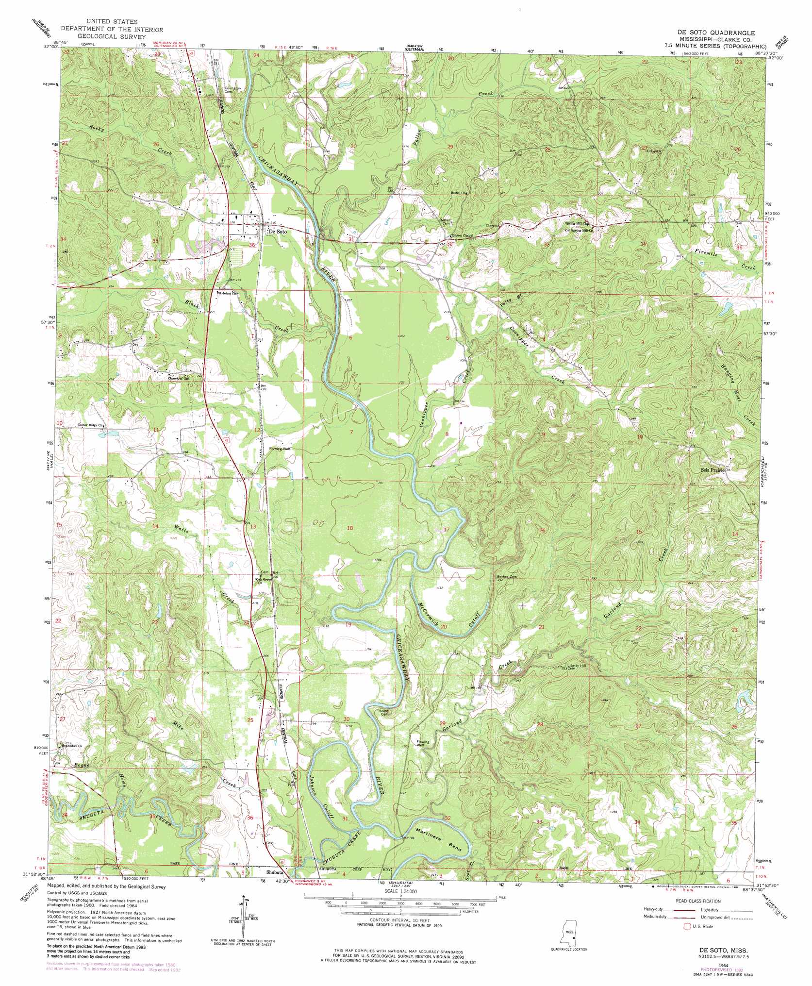
De Soto Topo Map Mississippi
To zoom in, hover over the map of De Soto
USGS Topo Quad 31088h6 - 1:24,000 scale
| Topo Map Name: | De Soto |
| USGS Topo Quad ID: | 31088h6 |
| Print Size: | ca. 21 1/4" wide x 27" high |
| Southeast Coordinates: | 31.875° N latitude / 88.625° W longitude |
| Map Center Coordinates: | 31.9375° N latitude / 88.6875° W longitude |
| U.S. State: | MS |
| Filename: | o31088h6.jpg |
| Download Map JPG Image: | De Soto topo map 1:24,000 scale |
| Map Type: | Topographic |
| Topo Series: | 7.5´ |
| Map Scale: | 1:24,000 |
| Source of Map Images: | United States Geological Survey (USGS) |
| Alternate Map Versions: |
De Soto MS 1964, updated 1965 Download PDF Buy paper map De Soto MS 1964, updated 1982 Download PDF Buy paper map De Soto MS 2012 Download PDF Buy paper map De Soto MS 2015 Download PDF Buy paper map |
1:24,000 Topo Quads surrounding De Soto
Rose Hill |
Stonewall |
Sable |
Snell |
Yantley |
Pachuta |
Wautubbee |
Quittman |
Sykes |
Hinton |
Heidelberg |
Hale |
De Soto |
Carmichael |
Melvin |
Heidelberg Sw |
Eucutta |
Shubuta |
Matherville |
Isney |
Myrick |
Whistler |
Waynesboro |
Denham |
Aquilla |
> Back to 31088e1 at 1:100,000 scale
> Back to 31088a1 at 1:250,000 scale
> Back to U.S. Topo Maps home
De Soto topo map: Gazetteer
De Soto: Bends
Martinere Bend elevation 57m 187′De Soto: Dams
Duke Lake Dam elevation 63m 206′Raymond Harris Pond Dam elevation 59m 193′
De Soto: Guts
Johnson Cutoff elevation 56m 183′McCormick Cutoff elevation 55m 180′
De Soto: Lakes
Barber Lake (historical) elevation 60m 196′De Soto: Oilfields
North Shubuta Oil Field elevation 61m 200′De Soto: Populated Places
De Soto elevation 64m 209′Gin (historical) elevation 97m 318′
Sels Prairie elevation 119m 390′
Sumrall elevation 60m 196′
De Soto: Streams
Black Creek elevation 52m 170′Bogue Homo elevation 56m 183′
Coonipper Creek elevation 51m 167′
Fallen Creek elevation 53m 173′
Garland Creek elevation 49m 160′
Mike Creek elevation 51m 167′
Polly Branch elevation 63m 206′
Rocky Creek elevation 54m 177′
Shubuta Creek elevation 49m 160′
Soot Creek elevation 49m 160′
Watts Creek elevation 50m 164′
Young Blood Creek elevation 70m 229′
De Soto digital topo map on disk
Buy this De Soto topo map showing relief, roads, GPS coordinates and other geographical features, as a high-resolution digital map file on DVD:
Gulf Coast (LA, MS, AL, FL) & Southwestern Georgia
Buy digital topo maps: Gulf Coast (LA, MS, AL, FL) & Southwestern Georgia
 & Southwestern Georgia map DVD")