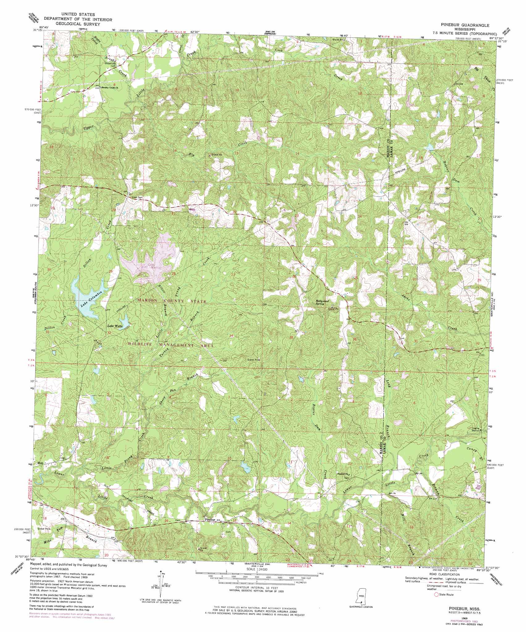
Pinebur Topo Map Mississippi
To zoom in, hover over the map of Pinebur
USGS Topo Quad 31089b6 - 1:24,000 scale
| Topo Map Name: | Pinebur |
| USGS Topo Quad ID: | 31089b6 |
| Print Size: | ca. 21 1/4" wide x 27" high |
| Southeast Coordinates: | 31.125° N latitude / 89.625° W longitude |
| Map Center Coordinates: | 31.1875° N latitude / 89.6875° W longitude |
| U.S. State: | MS |
| Filename: | o31089b6.jpg |
| Download Map JPG Image: | Pinebur topo map 1:24,000 scale |
| Map Type: | Topographic |
| Topo Series: | 7.5´ |
| Map Scale: | 1:24,000 |
| Source of Map Images: | United States Geological Survey (USGS) |
| Alternate Map Versions: |
Pinebur MS 1969, updated 1971 Download PDF Buy paper map Pinebur MS 1969, updated 1982 Download PDF Buy paper map Pinebur MS 2012 Download PDF Buy paper map Pinebur MS 2015 Download PDF Buy paper map |
1:24,000 Topo Quads surrounding Pinebur
Oak Vale |
Bunker Hill |
Bassfield |
Sumrall |
Sanford |
Morgantown |
Columbia North |
Improve |
Oloh |
Hattiesburg Sw |
Sandy Hook Nw |
Columbia South |
Pinebur |
Baxterville Ne |
Purvis |
Dexter |
Sandy Hook |
Baxterville Sw |
Baxterville |
Lumberton |
State Line |
Angie |
Fords Creek |
Orvisburg |
Hillsdale |
> Back to 31089a1 at 1:100,000 scale
> Back to 31088a1 at 1:250,000 scale
> Back to U.S. Topo Maps home
Pinebur topo map: Gazetteer
Pinebur: Dams
Bill Waller Lake Dam elevation 69m 226′Earkan Lake Dam elevation 72m 236′
Lake Columbia Dam elevation 61m 200′
Tom Watts Lake Dam elevation 60m 196′
Pinebur: Parks
Marion County State Wildlife Management Area elevation 61m 200′Pinebur: Populated Places
Pinebur elevation 43m 141′Pinebur: Reservoirs
Lake Bill Waller elevation 65m 213′Lake Columbia elevation 61m 200′
Lake Watts elevation 58m 190′
Pinebur: Springs
Hollywood Spring elevation 100m 328′Pinebur: Streams
Beaver Dam Creek elevation 49m 160′Big Creek elevation 55m 180′
Boggy Prong elevation 60m 196′
Brushy Creek elevation 56m 183′
Caney Branch elevation 49m 160′
Elbow Branch elevation 56m 183′
Graves Creek elevation 56m 183′
Gully Creek elevation 53m 173′
Little Prong Creek elevation 38m 124′
Long Branch elevation 48m 157′
Mill Branch elevation 50m 164′
Pitman Creek elevation 46m 150′
Sheep Pen Branch elevation 45m 147′
Turkey Branch elevation 45m 147′
Pinebur digital topo map on disk
Buy this Pinebur topo map showing relief, roads, GPS coordinates and other geographical features, as a high-resolution digital map file on DVD:
Gulf Coast (LA, MS, AL, FL) & Southwestern Georgia
Buy digital topo maps: Gulf Coast (LA, MS, AL, FL) & Southwestern Georgia
 & Southwestern Georgia map DVD")