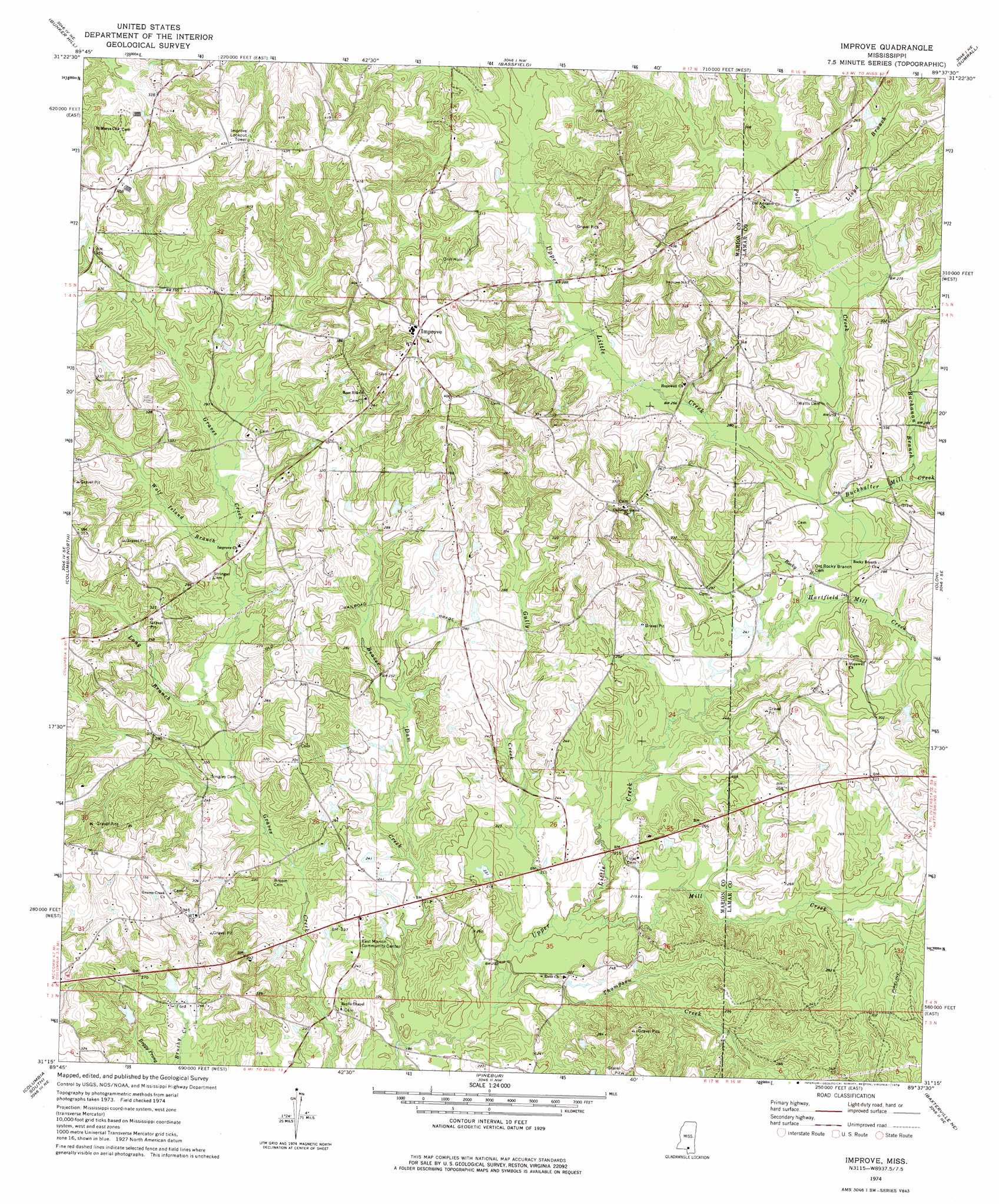
Improve Topo Map Mississippi
To zoom in, hover over the map of Improve
USGS Topo Quad 31089c6 - 1:24,000 scale
| Topo Map Name: | Improve |
| USGS Topo Quad ID: | 31089c6 |
| Print Size: | ca. 21 1/4" wide x 27" high |
| Southeast Coordinates: | 31.25° N latitude / 89.625° W longitude |
| Map Center Coordinates: | 31.3125° N latitude / 89.6875° W longitude |
| U.S. State: | MS |
| Filename: | o31089c6.jpg |
| Download Map JPG Image: | Improve topo map 1:24,000 scale |
| Map Type: | Topographic |
| Topo Series: | 7.5´ |
| Map Scale: | 1:24,000 |
| Source of Map Images: | United States Geological Survey (USGS) |
| Alternate Map Versions: |
Improve MS 2012 Download PDF Buy paper map Improve MS 2015 Download PDF Buy paper map |
1:24,000 Topo Quads surrounding Improve
Prentiss West |
Prentiss East |
Lake Mike Connor |
Williamsburg |
Seminary |
Oak Vale |
Bunker Hill |
Bassfield |
Sumrall |
Sanford |
Morgantown |
Columbia North |
Improve |
Oloh |
Hattiesburg Sw |
Sandy Hook Nw |
Columbia South |
Pinebur |
Baxterville Ne |
Purvis |
Dexter |
Sandy Hook |
Baxterville Sw |
Baxterville |
Lumberton |
> Back to 31089a1 at 1:100,000 scale
> Back to 31088a1 at 1:250,000 scale
> Back to U.S. Topo Maps home
Improve topo map: Gazetteer
Improve: Dams
Singley Lake Dam elevation 70m 229′Stogner Lake Dam elevation 70m 229′
W E Stogner Lake Dam elevation 64m 209′
Improve: Oilfields
Improve Oil Field elevation 79m 259′Improve: Populated Places
Enon elevation 68m 223′Hopewell elevation 84m 275′
Improve elevation 125m 410′
Rocky Branch elevation 83m 272′
Improve: Streams
Beaver Dam Creek elevation 53m 173′Bob Branch elevation 81m 265′
Buchanan Branch elevation 64m 209′
Buckhalter Mill Creek elevation 68m 223′
Cook Creek elevation 55m 180′
Ford Branch elevation 85m 278′
Gully Creek elevation 58m 190′
Hartfield Mill Creek elevation 67m 219′
Lloyd Branch elevation 88m 288′
Long Branch elevation 70m 229′
Mill Creek elevation 58m 190′
Polk Creek elevation 70m 229′
Rocky Branch elevation 68m 223′
Thompson Creek elevation 56m 183′
Wolf Island Branch elevation 76m 249′
Improve digital topo map on disk
Buy this Improve topo map showing relief, roads, GPS coordinates and other geographical features, as a high-resolution digital map file on DVD:
Gulf Coast (LA, MS, AL, FL) & Southwestern Georgia
Buy digital topo maps: Gulf Coast (LA, MS, AL, FL) & Southwestern Georgia
 & Southwestern Georgia map DVD")