Columbia North Topo Map Mississippi
To zoom in, hover over the map of Columbia North
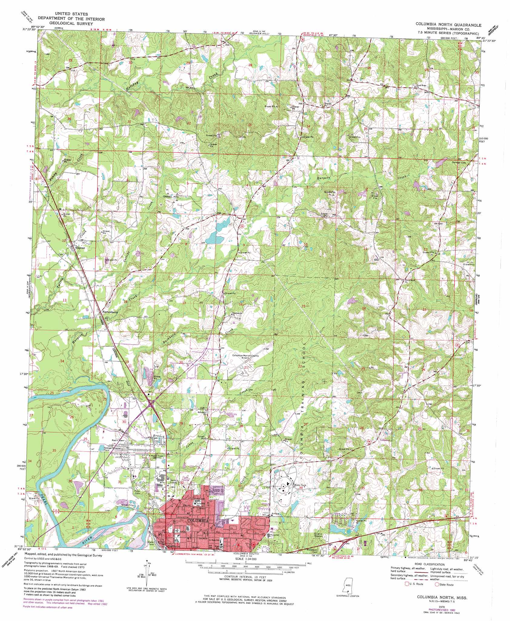
USGS Topo Quad 31089c7 - 1:24,000 scale
| Topo Map Name: | Columbia North |
| USGS Topo Quad ID: | 31089c7 |
| Print Size: | ca. 21 1/4" wide x 27" high |
| Southeast Coordinates: | 31.25° N latitude / 89.75° W longitude |
| Map Center Coordinates: | 31.3125° N latitude / 89.8125° W longitude |
| U.S. State: | MS |
| Filename: | o31089c7.jpg |
| Download Map JPG Image: | Columbia North topo map 1:24,000 scale |
| Map Type: | Topographic |
| Topo Series: | 7.5´ |
| Map Scale: | 1:24,000 |
| Source of Map Images: | United States Geological Survey (USGS) |
| Alternate Map Versions: |
Columbia North MS 1970, updated 1972 Download PDF Buy paper map Columbia North MS 1970, updated 1982 Download PDF Buy paper map Columbia North MS 1970, updated 1982 Download PDF Buy paper map Columbia North MS 2012 Download PDF Buy paper map Columbia North MS 2015 Download PDF Buy paper map |
1:24,000 Topo Quads surrounding Columbia North
Monticello |
Prentiss West |
Prentiss East |
Lake Mike Connor |
Williamsburg |
Tilton |
Oak Vale |
Bunker Hill |
Bassfield |
Sumrall |
Darbun |
Morgantown |
Columbia North |
Improve |
Oloh |
Kokomo |
Sandy Hook Nw |
Columbia South |
Pinebur |
Baxterville Ne |
Tylertown Se |
Dexter |
Sandy Hook |
Baxterville Sw |
Baxterville |
> Back to 31089a1 at 1:100,000 scale
> Back to 31088a1 at 1:250,000 scale
> Back to U.S. Topo Maps home
Columbia North topo map: Gazetteer
Columbia North: Airports
Columbia-Marion County Airport elevation 76m 249′Columbia North: Dams
Columbia Training School Lake Dam elevation 64m 209′Long Horn Lake Dam elevation 98m 321′
McDaniels Pond Dam elevation 74m 242′
Singley Lake Dam elevation 80m 262′
Whitehead Lake Dam elevation 75m 246′
Columbia North: Oilfields
Columbia Oil Field elevation 71m 232′East Morgantown Oil Field elevation 49m 160′
Columbia North: Parks
Columbia Water Park elevation 44m 144′Westerfield Little League Ball Park elevation 61m 200′
Columbia North: Populated Places
Columbia elevation 43m 141′Columbia Springs (historical) elevation 41m 134′
Emmanuel elevation 62m 203′
Expose elevation 51m 167′
Fortenberry elevation 55m 180′
Good Hope elevation 112m 367′
Harmony elevation 67m 219′
Columbia North: Streams
Black Branch elevation 39m 127′Buckhorn Creek elevation 37m 121′
Collins Creek elevation 45m 147′
Dry Creek elevation 36m 118′
Harper Creek elevation 37m 121′
Jones Creek elevation 36m 118′
Columbia North digital topo map on disk
Buy this Columbia North topo map showing relief, roads, GPS coordinates and other geographical features, as a high-resolution digital map file on DVD:
Gulf Coast (LA, MS, AL, FL) & Southwestern Georgia
Buy digital topo maps: Gulf Coast (LA, MS, AL, FL) & Southwestern Georgia
 & Southwestern Georgia map DVD")