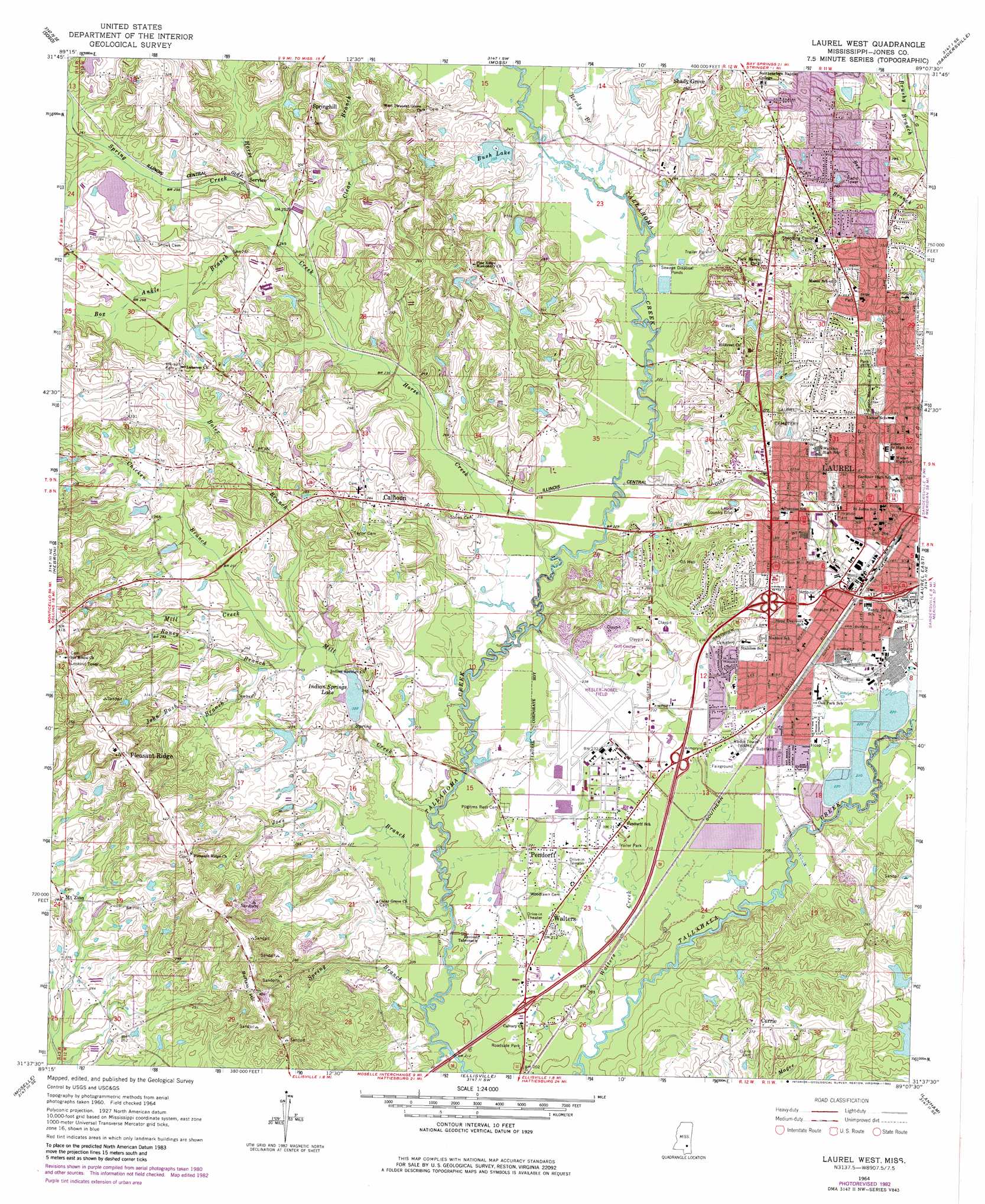
Laurel West Topo Map Mississippi
To zoom in, hover over the map of Laurel West
USGS Topo Quad 31089f2 - 1:24,000 scale
| Topo Map Name: | Laurel West |
| USGS Topo Quad ID: | 31089f2 |
| Print Size: | ca. 21 1/4" wide x 27" high |
| Southeast Coordinates: | 31.625° N latitude / 89.125° W longitude |
| Map Center Coordinates: | 31.6875° N latitude / 89.1875° W longitude |
| U.S. State: | MS |
| Filename: | o31089f2.jpg |
| Download Map JPG Image: | Laurel West topo map 1:24,000 scale |
| Map Type: | Topographic |
| Topo Series: | 7.5´ |
| Map Scale: | 1:24,000 |
| Source of Map Images: | United States Geological Survey (USGS) |
| Alternate Map Versions: |
Laurel West MS 1964, updated 1965 Download PDF Buy paper map Laurel West MS 1964, updated 1978 Download PDF Buy paper map Laurel West MS 1964, updated 1982 Download PDF Buy paper map Laurel West MS 2012 Download PDF Buy paper map Laurel West MS 2015 Download PDF Buy paper map |
1:24,000 Topo Quads surrounding Laurel West
Center Ridge |
Bay Springs |
Lake Como |
Waldrup |
Heidelberg |
Taylorsville |
Soso |
Moss |
Sandersville |
Heidelberg Sw |
Hot Coffee |
Hebron |
Laurel West |
Laurel East |
Myrick |
Seminary |
Moselle |
Ellisville |
Lanham |
Strengthford |
Sanford |
Eastabuchie |
Barrontown |
Ovett |
Rhodes |
> Back to 31089e1 at 1:100,000 scale
> Back to 31088a1 at 1:250,000 scale
> Back to U.S. Topo Maps home
Laurel West topo map: Gazetteer
Laurel West: Airports
Hesler-Noble Field elevation 72m 236′Laurel West: Crossings
Interchange 90 elevation 67m 219′Interchange 93 elevation 68m 223′
Interchange 95 elevation 76m 249′
Interchange 96A elevation 76m 249′
Laurel West: Dams
Bush Dairy Lake Dam elevation 78m 255′Bush Dairy Lake Dam elevation 70m 229′
Graftons Lake Dam elevation 71m 232′
Halstead Walker Lake Dam elevation 81m 265′
Halstead Walker Lake Dam elevation 76m 249′
Howard Parker Lake Dam elevation 85m 278′
Indian Springs Lake Dam elevation 68m 223′
James Hillburn Lake Dam elevation 89m 291′
Laurel Lagoon Dam elevation 67m 219′
Laurel Lagoon Dam elevation 68m 223′
Massey Sewage Lagoon Dam elevation 63m 206′
Morgan Pond Dam elevation 85m 278′
Vaughn Lake Dam elevation 74m 242′
Laurel West: Parks
Beacon Park elevation 73m 239′Cotton Mill Park elevation 85m 278′
Daphne Park elevation 86m 282′
Gardiner Park elevation 72m 236′
Mason Memorial Park elevation 78m 255′
Seventh Avenue Park elevation 80m 262′
Trinity Playground elevation 95m 311′
Watkins Stadium elevation 91m 298′
Laurel West: Populated Places
Calhoun elevation 85m 278′Currie elevation 83m 272′
Flynt elevation 67m 219′
Laurel elevation 82m 269′
Mount Zion elevation 87m 285′
Pendorff elevation 65m 213′
Pleasant Ridge elevation 126m 413′
Queensburg elevation 67m 219′
Service elevation 76m 249′
Springhill elevation 99m 324′
Walters elevation 64m 209′
Laurel West: Reservoirs
Bush Lake elevation 74m 242′Indian Springs Lake elevation 68m 223′
Laurel West: Streams
Boler Branch elevation 68m 223′Box Ankle Branch elevation 73m 239′
Chicken Branch elevation 71m 232′
Clear Branch elevation 73m 239′
Horse Creek elevation 63m 206′
Joes Branch elevation 57m 187′
John Bush Branch elevation 70m 229′
Mill Creek elevation 59m 193′
Reedy Branch elevation 67m 219′
Roney Branch elevation 70m 229′
Spring Branch elevation 58m 190′
Spring Creek elevation 76m 249′
Walters Creek elevation 57m 187′
Laurel West: Summits
Buffalo Hill elevation 124m 406′Laurel West digital topo map on disk
Buy this Laurel West topo map showing relief, roads, GPS coordinates and other geographical features, as a high-resolution digital map file on DVD:
Gulf Coast (LA, MS, AL, FL) & Southwestern Georgia
Buy digital topo maps: Gulf Coast (LA, MS, AL, FL) & Southwestern Georgia
 & Southwestern Georgia map DVD")