Hot Coffee Topo Map Mississippi
To zoom in, hover over the map of Hot Coffee
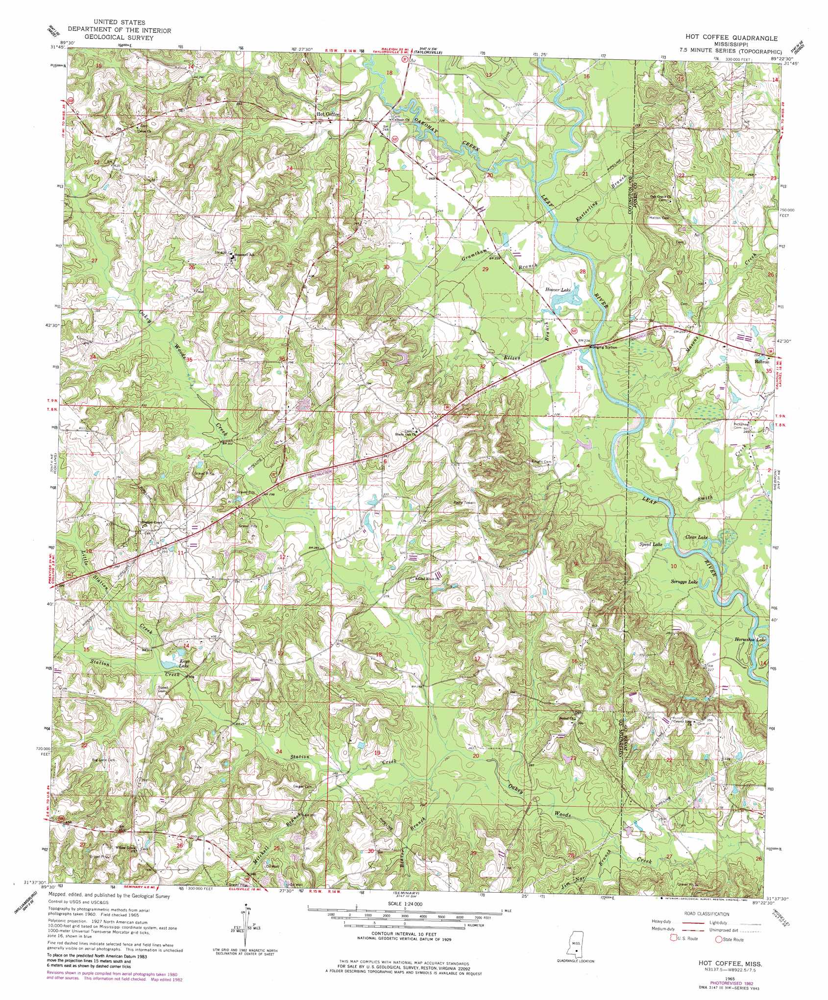
USGS Topo Quad 31089f4 - 1:24,000 scale
| Topo Map Name: | Hot Coffee |
| USGS Topo Quad ID: | 31089f4 |
| Print Size: | ca. 21 1/4" wide x 27" high |
| Southeast Coordinates: | 31.625° N latitude / 89.375° W longitude |
| Map Center Coordinates: | 31.6875° N latitude / 89.4375° W longitude |
| U.S. State: | MS |
| Filename: | o31089f4.jpg |
| Download Map JPG Image: | Hot Coffee topo map 1:24,000 scale |
| Map Type: | Topographic |
| Topo Series: | 7.5´ |
| Map Scale: | 1:24,000 |
| Source of Map Images: | United States Geological Survey (USGS) |
| Alternate Map Versions: |
Hot Coffee MS 1965, updated 1966 Download PDF Buy paper map Hot Coffee MS 1965, updated 1982 Download PDF Buy paper map Hot Coffee MS 2012 Download PDF Buy paper map Hot Coffee MS 2015 Download PDF Buy paper map |
1:24,000 Topo Quads surrounding Hot Coffee
Magee North |
Cohay |
Center Ridge |
Bay Springs |
Lake Como |
Magee South |
Mize |
Taylorsville |
Soso |
Moss |
Lone Star |
Collins |
Hot Coffee |
Hebron |
Laurel West |
Lake Mike Connor |
Williamsburg |
Seminary |
Moselle |
Ellisville |
Bassfield |
Sumrall |
Sanford |
Eastabuchie |
Barrontown |
> Back to 31089e1 at 1:100,000 scale
> Back to 31088a1 at 1:250,000 scale
> Back to U.S. Topo Maps home
Hot Coffee topo map: Gazetteer
Hot Coffee: Bridges
Reddochs Bridge elevation 63m 206′Hot Coffee: Dams
Charles Pickering Catfish Ponds Dam elevation 73m 239′Charles Pickering Catfish Ponds Dam elevation 73m 239′
Charles Pickering Lake Dam elevation 78m 255′
Hoover Lake Dam elevation 70m 229′
Hot Coffee: Lakes
Clear Lake elevation 64m 209′Horseshoe Lake elevation 63m 206′
Keys Lake elevation 95m 311′
Scruggs Lake elevation 64m 209′
Speed Lake elevation 63m 206′
Hot Coffee: Populated Places
Bethel elevation 111m 364′Hopewell elevation 124m 406′
Leaf River elevation 111m 364′
Reddochs elevation 70m 229′
Shady Oak elevation 120m 393′
Speedtown elevation 111m 364′
Station Creek elevation 122m 400′
Union elevation 122m 400′
Willowtown elevation 120m 393′
Hot Coffee: Post Offices
Welch Post Office (historical) elevation 102m 334′Hot Coffee: Reservoirs
Hoover Lake elevation 67m 219′Hot Coffee: Ridges
Negro Ridge elevation 126m 413′Hot Coffee: Streams
Beaver Branch elevation 79m 259′Easterling Branch elevation 64m 209′
Ellzey Branch elevation 62m 203′
Gramtham Branch elevation 64m 209′
Jim Nar Branch elevation 73m 239′
Little Station Creek elevation 92m 301′
Masons Creek elevation 63m 206′
Mitchell Branch elevation 84m 275′
Oakohay Creek elevation 66m 216′
Smith Creek elevation 61m 200′
Station Creek elevation 79m 259′
Hot Coffee digital topo map on disk
Buy this Hot Coffee topo map showing relief, roads, GPS coordinates and other geographical features, as a high-resolution digital map file on DVD:
Gulf Coast (LA, MS, AL, FL) & Southwestern Georgia
Buy digital topo maps: Gulf Coast (LA, MS, AL, FL) & Southwestern Georgia
 & Southwestern Georgia map DVD")