Turnbull Island Topo Map Louisiana
To zoom in, hover over the map of Turnbull Island
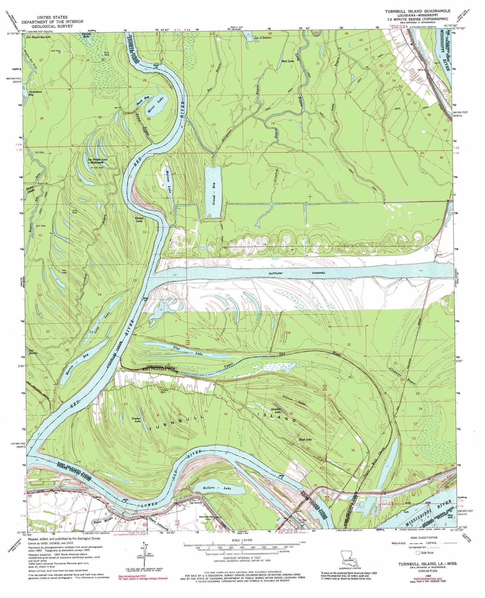
USGS Topo Quad 31091a6 - 1:24,000 scale
| Topo Map Name: | Turnbull Island |
| USGS Topo Quad ID: | 31091a6 |
| Print Size: | ca. 21 1/4" wide x 27" high |
| Southeast Coordinates: | 31° N latitude / 91.625° W longitude |
| Map Center Coordinates: | 31.0625° N latitude / 91.6875° W longitude |
| U.S. States: | LA, MS |
| Filename: | o31091a6.jpg |
| Download Map JPG Image: | Turnbull Island topo map 1:24,000 scale |
| Map Type: | Topographic |
| Topo Series: | 7.5´ |
| Map Scale: | 1:24,000 |
| Source of Map Images: | United States Geological Survey (USGS) |
| Alternate Map Versions: |
Turnbull Island LA 1965, updated 1966 Download PDF Buy paper map Turnbull Island LA 1965, updated 1975 Download PDF Buy paper map Turnbull Island LA 1965, updated 1990 Download PDF Buy paper map Turnbull Island LA 1996, updated 1999 Download PDF Buy paper map Turnbull Island LA 2012 Download PDF Buy paper map Turnbull Island LA 2015 Download PDF Buy paper map |
1:24,000 Topo Quads surrounding Turnbull Island
Larto Lake South |
Acme |
Slocum |
Fairview |
Buck Island |
Lac Sainte Agnes |
Ile Natchitoches |
Shaw |
Lake Mary |
Lessley |
Moreauville |
Big Bend |
Turnbull Island |
Fort Adams |
Pinckneyville |
Plaucheville |
Simmesport |
Innis |
Tunica |
Weyanoke |
Bayou Jack |
Bayou Current |
Batchelor |
Lacour |
Saint Francisville |
> Back to 31091a1 at 1:100,000 scale
> Back to 31090a1 at 1:250,000 scale
> Back to U.S. Topo Maps home
Turnbull Island topo map: Gazetteer
Turnbull Island: Bays
Cockleburr Bay elevation 8m 26′Turnbull Island: Dams
Old River Lock elevation 16m 52′Turnbull Island: Islands
Turnbull Island elevation 15m 49′Turnbull Island: Lakes
Flat Lake elevation 9m 29′Grand Bay elevation 8m 26′
Kellers Lake elevation 9m 29′
Lac A'Sostien elevation 9m 29′
Les Petits Lacs à Blakewood elevation 11m 36′
Long Lake elevation 10m 32′
Martin Bay elevation 10m 32′
Moreau Lake elevation 10m 32′
Morel Lake elevation 11m 36′
Mud Lake elevation 9m 29′
Quarter Lake elevation 14m 45′
Shark Bay elevation 11m 36′
Timber Lake elevation 14m 45′
Turnbull Island: Levees
Above Old River Revetment elevation 13m 42′Coochie Revetment elevation 14m 45′
North Bank Revetment elevation 9m 29′
Turnbull Island Revetment elevation 9m 29′
Turnbull Island: Oilfields
Lower Ballymagan Oil Field elevation 16m 52′Turnbull Island: Parks
Three Rivers Wildlife Management Area elevation 10m 32′Turnbull Island: Populated Places
Ashridge (historical) elevation 13m 42′Merrick elevation 14m 45′
Naples (historical) elevation 9m 29′
Turnbull Island: Streams
Bayou Dindy elevation 9m 29′Crooked Bayou elevation 11m 36′
Crooked Bayou elevation 9m 29′
Long Bayou elevation 9m 29′
Lower Old River elevation 9m 29′
Pump Bayou elevation 10m 32′
Red River elevation 9m 29′
Sugar Mill Chute elevation 13m 42′
Upper Old River elevation 10m 32′
Turnbull Island: Swamps
Gibson Lake elevation 14m 45′Grand Lake elevation 9m 29′
Road Lake elevation 11m 36′
Turnbull Island digital topo map on disk
Buy this Turnbull Island topo map showing relief, roads, GPS coordinates and other geographical features, as a high-resolution digital map file on DVD: