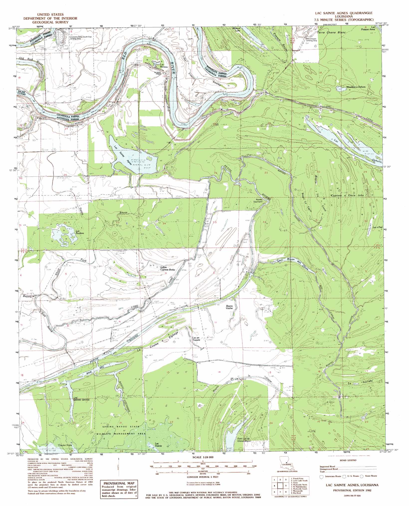
Lac Sainte Agnes Topo Map Louisiana
To zoom in, hover over the map of Lac Sainte Agnes
USGS Topo Quad 31091b8 - 1:24,000 scale
| Topo Map Name: | Lac Sainte Agnes |
| USGS Topo Quad ID: | 31091b8 |
| Print Size: | ca. 21 1/4" wide x 27" high |
| Southeast Coordinates: | 31.125° N latitude / 91.875° W longitude |
| Map Center Coordinates: | 31.1875° N latitude / 91.9375° W longitude |
| U.S. State: | LA |
| Filename: | o31091b8.jpg |
| Download Map JPG Image: | Lac Sainte Agnes topo map 1:24,000 scale |
| Map Type: | Topographic |
| Topo Series: | 7.5´ |
| Map Scale: | 1:24,000 |
| Source of Map Images: | United States Geological Survey (USGS) |
| Alternate Map Versions: |
Lac Sainte Agnes LA 1982, updated 1983 Download PDF Buy paper map Lac Sainte Agnes LA 1999, updated 2004 Download PDF Buy paper map Lac Sainte Agnes LA 2012 Download PDF Buy paper map Lac Sainte Agnes LA 2015 Download PDF Buy paper map |
1:24,000 Topo Quads surrounding Lac Sainte Agnes
Holloway |
Buckeye Ne |
Larto Lake North |
Mayna |
Monterey |
Buckeye |
Powell Point |
Larto Lake South |
Acme |
Slocum |
Effie |
Marksville North |
Lac Sainte Agnes |
Ile Natchitoches |
Shaw |
Belle D'Eau |
Marksville South |
Moreauville |
Big Bend |
Turnbull Island |
Bunkie |
Cottonport |
Plaucheville |
Simmesport |
Innis |
> Back to 31091a1 at 1:100,000 scale
> Back to 31090a1 at 1:250,000 scale
> Back to U.S. Topo Maps home
Lac Sainte Agnes topo map: Gazetteer
Lac Sainte Agnes: Airports
Louisiana Delta South End Landing Strip elevation 17m 55′Lac Sainte Agnes: Bays
Baie Sec elevation 13m 42′Lac Sainte Agnes: Capes
Pointe Tournant elevation 14m 45′Lac Sainte Agnes: Lakes
Bayou Voinche elevation 14m 45′Lac a Paul elevation 13m 42′
Lac Ambroise elevation 13m 42′
Lac Bryon de Chats elevation 13m 42′
Lac Clair elevation 13m 42′
Lac en Travers elevation 14m 45′
Lac Grand Bayou elevation 13m 42′
Lac Moreau elevation 15m 49′
Lac Ophelia elevation 14m 45′
Lac Sainte Agnes elevation 12m 39′
Lac Saulière elevation 13m 42′
Lac Valerie elevation 13m 42′
Lake Little Solier elevation 13m 42′
Mouillere a Dehors elevation 14m 45′
Petit Lac du Grand Bryon elevation 13m 42′
Petit Lac Saulière elevation 13m 42′
Lac Sainte Agnes: Oilfields
Lake Ophelia Oil Field elevation 14m 45′Little River Oil Field elevation 13m 42′
Lac Sainte Agnes: Streams
Bayou Cocodrie elevation 13m 42′Bayou de la Glaise elevation 13m 42′
Bayou Voiche elevation 13m 42′
Big Canal elevation 13m 42′
La Coulee à Elphege elevation 13m 42′
Long Fork elevation 13m 42′
Old Red River elevation 19m 62′
Short Fork elevation 13m 42′
Twisty Bayou elevation 12m 39′
Lac Sainte Agnes: Swamps
Bayou Chambré elevation 13m 42′Bayou La Croix elevation 13m 42′
Bayou La Taure elevation 13m 42′
Bill Book Lake elevation 15m 49′
Cypriere a Oncle John elevation 13m 42′
Cyprière à Oncle John elevation 13m 42′
Grand Cyprière elevation 13m 42′
Indian Cypress Brake elevation 13m 42′
La Saulière elevation 13m 42′
Lac Barbue elevation 13m 42′
Lake Frazier Swamp elevation 10m 32′
Lac Sainte Agnes digital topo map on disk
Buy this Lac Sainte Agnes topo map showing relief, roads, GPS coordinates and other geographical features, as a high-resolution digital map file on DVD: