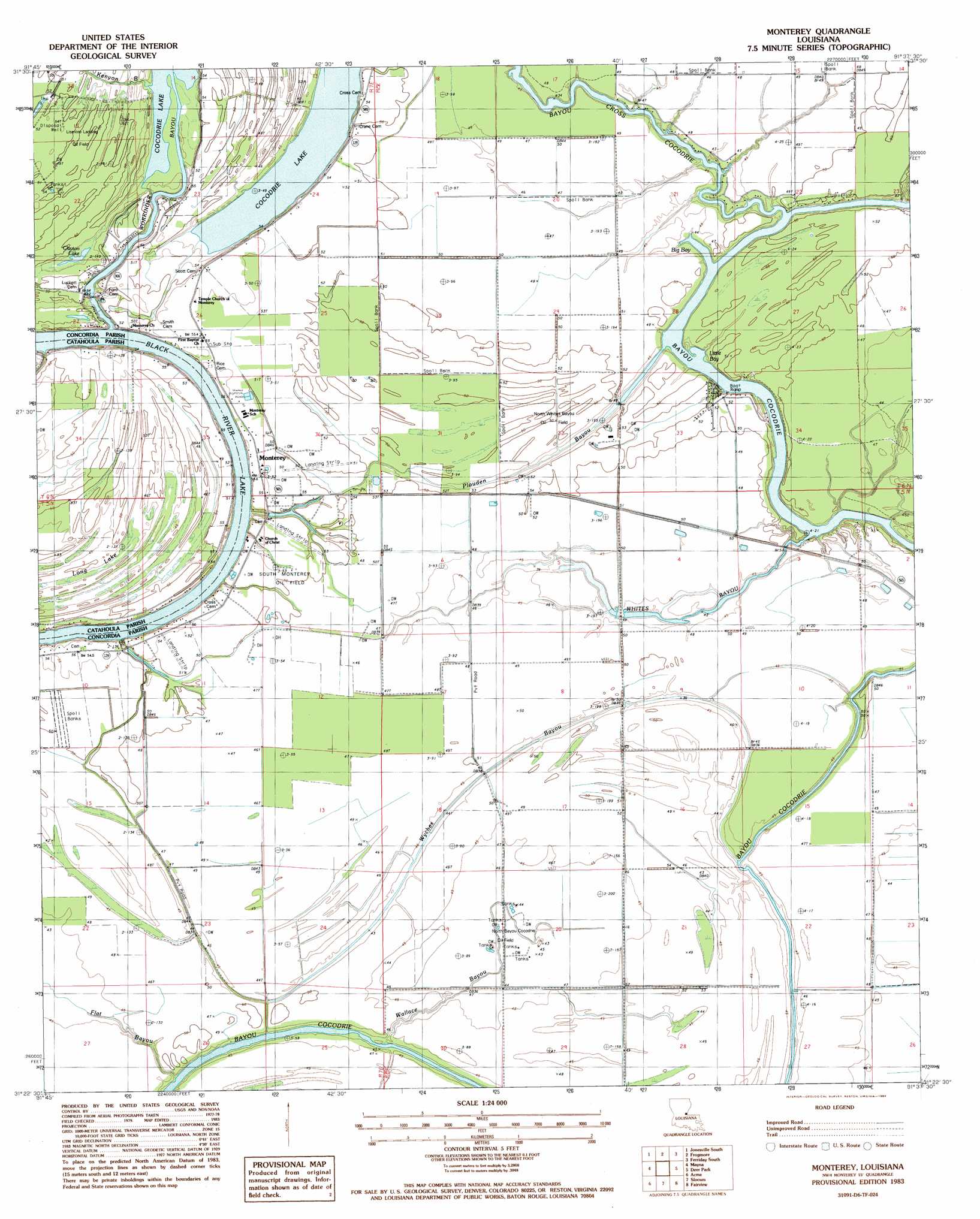
Monterey Topo Map Louisiana
To zoom in, hover over the map of Monterey
USGS Topo Quad 31091d6 - 1:24,000 scale
| Topo Map Name: | Monterey |
| USGS Topo Quad ID: | 31091d6 |
| Print Size: | ca. 21 1/4" wide x 27" high |
| Southeast Coordinates: | 31.375° N latitude / 91.625° W longitude |
| Map Center Coordinates: | 31.4375° N latitude / 91.6875° W longitude |
| U.S. State: | LA |
| Filename: | o31091d6.jpg |
| Download Map JPG Image: | Monterey topo map 1:24,000 scale |
| Map Type: | Topographic |
| Topo Series: | 7.5´ |
| Map Scale: | 1:24,000 |
| Source of Map Images: | United States Geological Survey (USGS) |
| Alternate Map Versions: |
Monterey LA 1983, updated 1984 Download PDF Buy paper map Monterey LA 2012 Download PDF Buy paper map Monterey LA 2015 Download PDF Buy paper map |
1:24,000 Topo Quads surrounding Monterey
Manifest |
Jonesville North |
Dunbarton |
Ferriday North |
Spokane |
Walters |
Jonesville South |
Frogmore |
Ferriday South |
Natchez |
Larto Lake North |
Mayna |
Monterey |
Deer Park |
Sibley |
Larto Lake South |
Acme |
Slocum |
Fairview |
Buck Island |
Lac Sainte Agnes |
Ile Natchitoches |
Shaw |
Lake Mary |
Lessley |
> Back to 31091a1 at 1:100,000 scale
> Back to 31090a1 at 1:250,000 scale
> Back to U.S. Topo Maps home
Monterey topo map: Gazetteer
Monterey: Bays
Big Bay elevation 12m 39′Little Bay elevation 11m 36′
Monterey: Islands
Horse Shoe Island elevation 15m 49′Monterey: Lakes
Clayton Lake elevation 13m 42′Long Lake elevation 12m 39′
Monterey: Oilfields
East Kincaid Bayou Oil Field elevation 17m 55′Lismore Landing Oil Field elevation 16m 52′
North Bayou Cocodrie Oil Field elevation 12m 39′
North Whites Bayou Oil Field elevation 15m 49′
Northeast Bayou Cocodrie Oil Field elevation 14m 45′
Northwest Bayou Cocadrie Oil Field elevation 12m 39′
Quinn Bayou Oil Field elevation 14m 45′
South Monterey Oil Field elevation 15m 49′
South Quinn Bayou Oil Field elevation 14m 45′
Wyches Bayou Oil Field elevation 14m 45′
Monterey: Populated Places
Monterey elevation 17m 55′Monterey: Post Offices
Monterey Post Office elevation 17m 55′Monterey: Streams
Bayou Cross Cocodrie elevation 14m 45′Flat Bayou elevation 11m 36′
Kenyon Bayou elevation 11m 36′
Plouden Bayou elevation 12m 39′
Wallace Bayou elevation 11m 36′
Wallace Bayou elevation 11m 36′
Whites Bayou elevation 12m 39′
Workinger Bayou elevation 9m 29′
Wyches Bayou elevation 12m 39′
Monterey digital topo map on disk
Buy this Monterey topo map showing relief, roads, GPS coordinates and other geographical features, as a high-resolution digital map file on DVD: