Mayna Topo Map Louisiana
To zoom in, hover over the map of Mayna
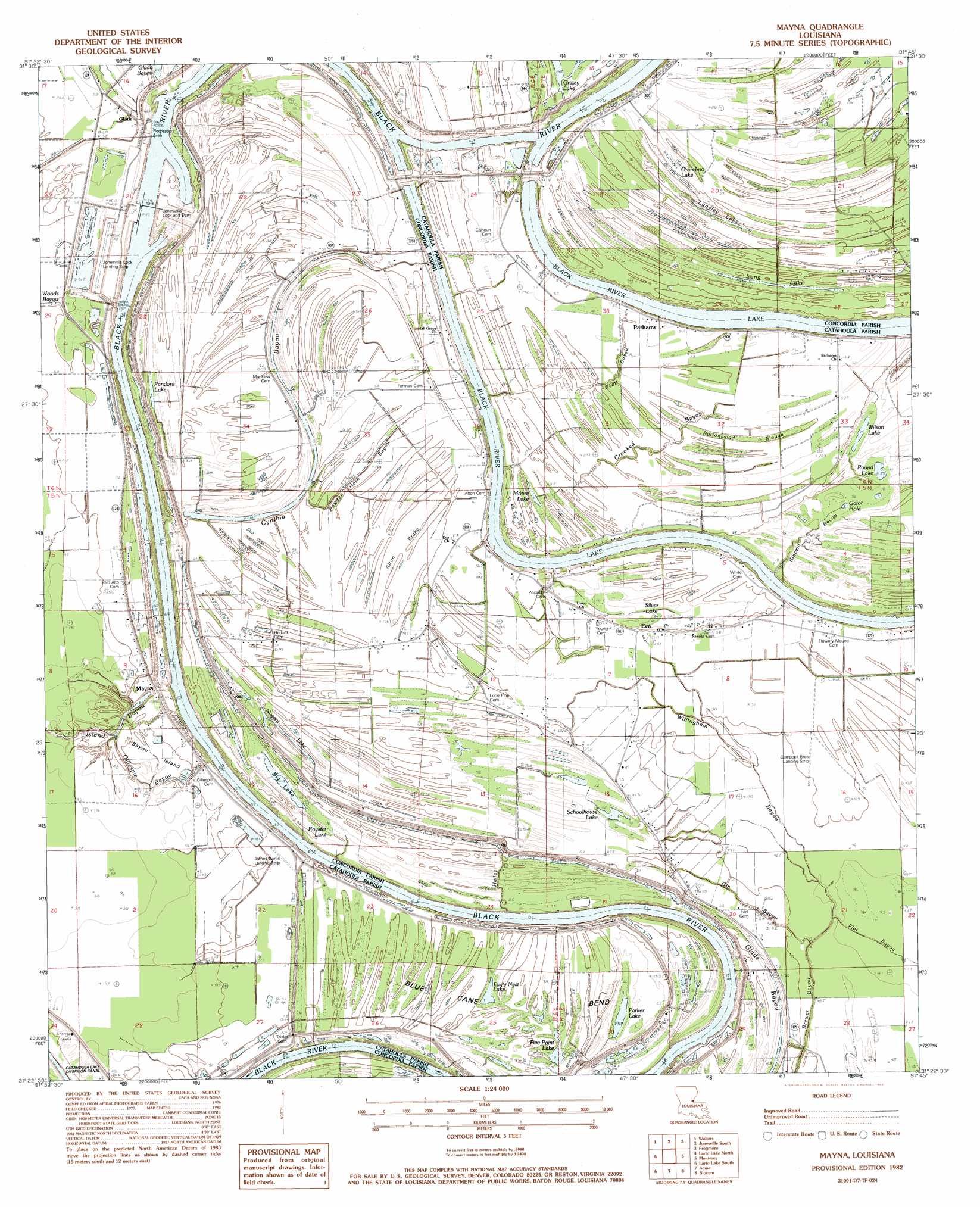
USGS Topo Quad 31091d7 - 1:24,000 scale
| Topo Map Name: | Mayna |
| USGS Topo Quad ID: | 31091d7 |
| Print Size: | ca. 21 1/4" wide x 27" high |
| Southeast Coordinates: | 31.375° N latitude / 91.75° W longitude |
| Map Center Coordinates: | 31.4375° N latitude / 91.8125° W longitude |
| U.S. State: | LA |
| Filename: | o31091d7.jpg |
| Download Map JPG Image: | Mayna topo map 1:24,000 scale |
| Map Type: | Topographic |
| Topo Series: | 7.5´ |
| Map Scale: | 1:24,000 |
| Source of Map Images: | United States Geological Survey (USGS) |
| Alternate Map Versions: |
Mayna LA 1982, updated 1983 Download PDF Buy paper map Mayna LA 2012 Download PDF Buy paper map Mayna LA 2015 Download PDF Buy paper map |
1:24,000 Topo Quads surrounding Mayna
Jena East |
Manifest |
Jonesville North |
Dunbarton |
Ferriday North |
Bird Island Point |
Walters |
Jonesville South |
Frogmore |
Ferriday South |
Buckeye Ne |
Larto Lake North |
Mayna |
Monterey |
Deer Park |
Powell Point |
Larto Lake South |
Acme |
Slocum |
Fairview |
Marksville North |
Lac Sainte Agnes |
Ile Natchitoches |
Shaw |
Lake Mary |
> Back to 31091a1 at 1:100,000 scale
> Back to 31090a1 at 1:250,000 scale
> Back to U.S. Topo Maps home
Mayna topo map: Gazetteer
Mayna: Airports
Blount Airport elevation 16m 52′Campbell Brothers Landing Strip elevation 15m 49′
James Curtis Landing Strip elevation 16m 52′
Jonesville Lock Landing Strip elevation 24m 78′
Mayna: Bends
Blue Cane Bend elevation 15m 49′Mayna: Dams
Jonesville Closure Dam elevation 15m 49′Jonesville Lock and Dam elevation 9m 29′
Mayna: Guts
Buttonwood Slough elevation 15m 49′Gator Hole elevation 12m 39′
Glade Bayou elevation 12m 39′
Mayna: Islands
Bayou Island elevation 15m 49′Mayna: Lakes
Big Lake elevation 13m 42′Black River Lake elevation 10m 32′
Crouch Lake elevation 13m 42′
Crowders Lake elevation 14m 45′
Eagle Nest Lake elevation 13m 42′
Five Point Lake elevation 14m 45′
Grandma Lake elevation 15m 49′
Langley Lake elevation 16m 52′
Long Lake elevation 13m 42′
Moore Lake elevation 13m 42′
Nugent Lake elevation 16m 52′
Pandora Lake elevation 13m 42′
Parker Lake elevation 12m 39′
Round Lake elevation 12m 39′
Royster Lake elevation 13m 42′
Schoolhouse Lake elevation 14m 45′
Silver Lake elevation 12m 39′
Wilson Lake elevation 11m 36′
Mayna: Oilfields
Cynthia Bayou Oil Field elevation 13m 42′Scott Bayou Oil Field elevation 15m 49′
South Cynthia Bayou Oil Field elevation 15m 49′
Mayna: Populated Places
Alton (historical) elevation 16m 52′Armagh elevation 17m 55′
Eva elevation 16m 52′
Flowery Mound (historical) elevation 15m 49′
Glade elevation 17m 55′
Mayna elevation 16m 52′
Parhams elevation 17m 55′
Serena elevation 17m 55′
Mayna: Post Offices
Serena Post Office (historical) elevation 17m 55′Mayna: Streams
Crooked Bayou elevation 11m 36′Cynthia Bayou elevation 13m 42′
Gillespie Bayou elevation 9m 29′
Gin Bayou elevation 13m 42′
Halley Bayou elevation 8m 26′
Kincaid Bayou elevation 10m 32′
Powder Horn Bayou elevation 12m 39′
Scott Bayou elevation 10m 32′
Willingham Bayou elevation 12m 39′
Mayna: Swamps
Alton Brake elevation 15m 49′Mayna digital topo map on disk
Buy this Mayna topo map showing relief, roads, GPS coordinates and other geographical features, as a high-resolution digital map file on DVD: