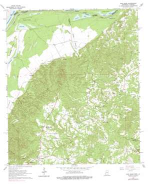
Pine Ridge Topo Map Mississippi
To zoom in, hover over the map of Pine Ridge
USGS Topo Quad 31091f3 - 1:24,000 scale
| Topo Map Name: | Pine Ridge |
| USGS Topo Quad ID: | 31091f3 |
| Print Size: | ca. 21 1/4" wide x 27" high |
| Southeast Coordinates: | 31.625° N latitude / 91.25° W longitude |
| Map Center Coordinates: | 31.6875° N latitude / 91.3125° W longitude |
| U.S. States: | MS, LA |
| Filename: | o31091f3.jpg |
| Download Map JPG Image: | Pine Ridge topo map 1:24,000 scale |
| Map Type: | Topographic |
| Topo Series: | 7.5´ |
| Map Scale: | 1:24,000 |
| Source of Map Images: | United States Geological Survey (USGS) |
| Alternate Map Versions: |
Pine Ridge MS 1963, updated 1964 Download PDF Buy paper map Pine Ridge MS 1963, updated 1976 Download PDF Buy paper map Pine Ridge MS 1963, updated 1976 Download PDF Buy paper map Pine Ridge MS 2012 Download PDF Buy paper map Pine Ridge MS 2015 Download PDF Buy paper map |
1:24,000 Topo Quads surrounding Pine Ridge
> Back to 31091e1 at 1:100,000 scale
> Back to 31090a1 at 1:250,000 scale
> Back to U.S. Topo Maps home
Pine Ridge topo map: Gazetteer
Pine Ridge: Dams
Carl Anderson Lake Dam elevation 13m 42′Pine Ridge: Guts
Dies Slough elevation 13m 42′Pumping Station Slough elevation 14m 45′
Pine Ridge: Islands
Mercer Island elevation 18m 59′Pine Ridge: Lakes
Duck Pond elevation 16m 52′Duck Pond elevation 16m 52′
Fields Lake elevation 13m 42′
Junkins Lake elevation 15m 49′
Pumpkin Lake elevation 16m 52′
Pine Ridge: Oilfields
Anna Oil Field elevation 70m 229′Edgewood Oil Field elevation 86m 282′
Fairchilds Creek Oil Field elevation 80m 262′
Greens Bayou Oil Field elevation 64m 209′
Mercer Oil Field elevation 20m 65′
Oakland Oil Field elevation 79m 259′
Painters Oil Field elevation 29m 95′
Pine Mount Oil Field elevation 75m 246′
Pine Ridge Oil Field elevation 54m 177′
Quitman Bayou Oil Field elevation 23m 75′
Stanton Oil Field elevation 91m 298′
Vernon Oil Field elevation 80m 262′
West Fairchilds Creek Oil Field elevation 82m 269′
West Pine Ridge Oil Field elevation 66m 216′
Pine Ridge: Populated Places
Anna elevation 29m 95′Pine Ridge elevation 85m 278′
Pine Ridge: Streams
Blueskin Creek elevation 21m 68′Dunbar Bayou elevation 46m 150′
Fairchilds Creek elevation 14m 45′
Pine Mount Bayou elevation 43m 141′
Sandy Bayou elevation 30m 98′
Wades Bayou elevation 34m 111′
Pine Ridge digital topo map on disk
Buy this Pine Ridge topo map showing relief, roads, GPS coordinates and other geographical features, as a high-resolution digital map file on DVD:


