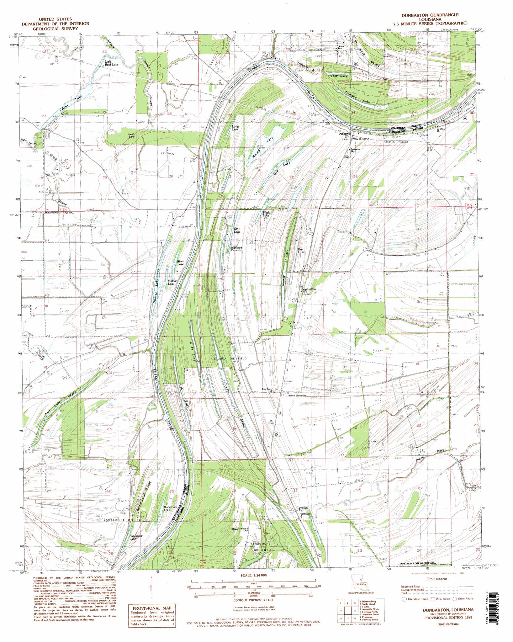
Dunbarton Topo Map Louisiana
To zoom in, hover over the map of Dunbarton
USGS Topo Quad 31091f6 - 1:24,000 scale
| Topo Map Name: | Dunbarton |
| USGS Topo Quad ID: | 31091f6 |
| Print Size: | ca. 21 1/4" wide x 27" high |
| Southeast Coordinates: | 31.625° N latitude / 91.625° W longitude |
| Map Center Coordinates: | 31.6875° N latitude / 91.6875° W longitude |
| U.S. State: | LA |
| Filename: | o31091f6.jpg |
| Download Map JPG Image: | Dunbarton topo map 1:24,000 scale |
| Map Type: | Topographic |
| Topo Series: | 7.5´ |
| Map Scale: | 1:24,000 |
| Source of Map Images: | United States Geological Survey (USGS) |
| Alternate Map Versions: |
Dunbarton LA 1983, updated 1984 Download PDF Buy paper map Dunbarton LA 2012 Download PDF Buy paper map Dunbarton LA 2015 Download PDF Buy paper map |
1:24,000 Topo Quads surrounding Dunbarton
Enterprise |
Extension |
Wisner |
Oakley |
Gretna Green |
Aimwell |
Harrisonburg |
Sicily Island |
Foules |
Waterproof |
Manifest |
Jonesville North |
Dunbarton |
Ferriday North |
Spokane |
Walters |
Jonesville South |
Frogmore |
Ferriday South |
Natchez |
Larto Lake North |
Mayna |
Monterey |
Deer Park |
Sibley |
> Back to 31091e1 at 1:100,000 scale
> Back to 31090a1 at 1:250,000 scale
> Back to U.S. Topo Maps home
Dunbarton topo map: Gazetteer
Dunbarton: Guts
Bens Bayou elevation 12m 39′Big Cash Bayou elevation 15m 49′
Brushy Bayou elevation 14m 45′
Buttonwood Bayou elevation 15m 49′
Hollywood Bayou elevation 16m 52′
Little Haha Bayou elevation 13m 42′
Pool Lake Bayou elevation 15m 49′
Smith Bayou elevation 16m 52′
Sutton Bayou elevation 13m 42′
Dunbarton: Lakes
Bee Lake elevation 18m 59′Bens Lake elevation 14m 45′
Black Lake elevation 17m 55′
Dead Lake elevation 15m 49′
Dry Lake elevation 15m 49′
Fish Lake elevation 15m 49′
Gin Lake elevation 17m 55′
Knockanat Lake elevation 17m 55′
Little Bens Lake elevation 14m 45′
Long Lake elevation 17m 55′
Middle Lake elevation 17m 55′
River Lake elevation 17m 55′
Round Lake elevation 16m 52′
Shanty Lake elevation 16m 52′
Sunflower Lake elevation 14m 45′
Swazee Lake elevation 17m 55′
Trap Lake elevation 14m 45′
Twomile Lake elevation 15m 49′
Wade Lake elevation 15m 49′
Dunbarton: Oilfields
Ballina Oil Field elevation 17m 55′Frogmore Oil Field elevation 15m 49′
Jonesville Oil Field elevation 19m 62′
Northeast Frogmore Oil Field elevation 18m 59′
Dunbarton: Populated Places
Ballina elevation 18m 59′Dunbarton elevation 18m 59′
Dunbarton: Swamps
Buttonwood Brake elevation 14m 45′Dunbarton digital topo map on disk
Buy this Dunbarton topo map showing relief, roads, GPS coordinates and other geographical features, as a high-resolution digital map file on DVD: