Chamblee Topo Map Louisiana
To zoom in, hover over the map of Chamblee
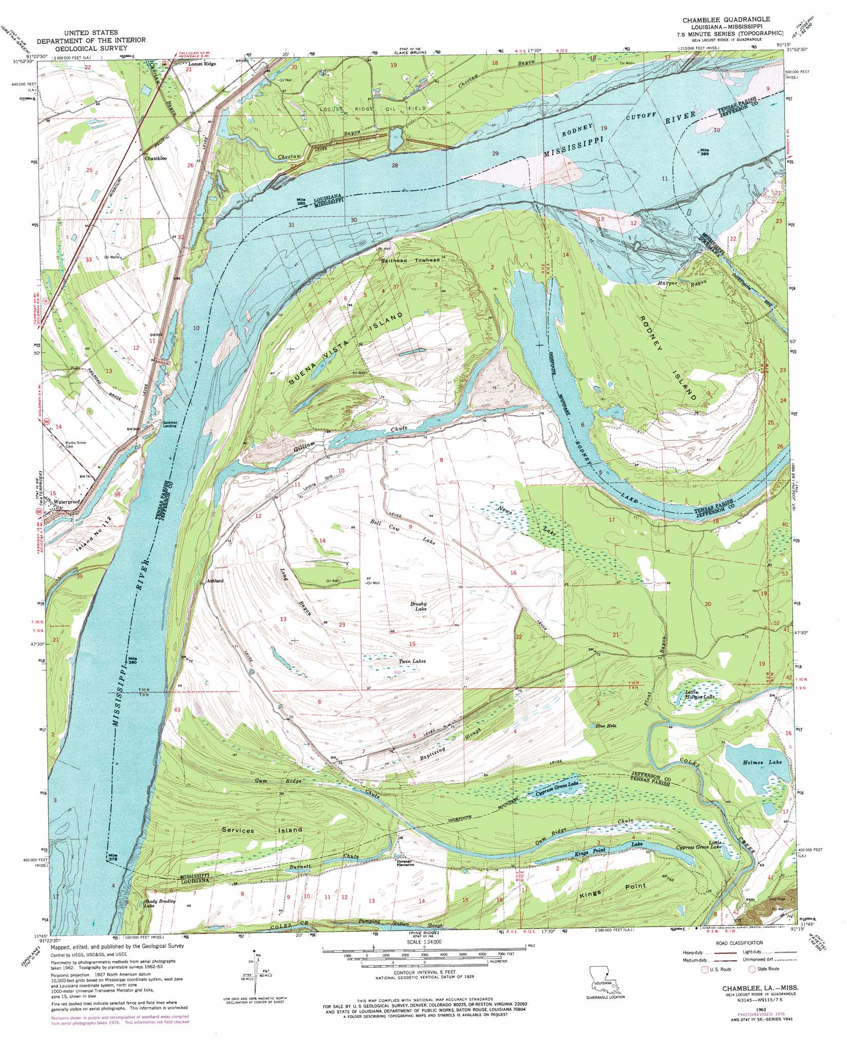
USGS Topo Quad 31091g3 - 1:24,000 scale
| Topo Map Name: | Chamblee |
| USGS Topo Quad ID: | 31091g3 |
| Print Size: | ca. 21 1/4" wide x 27" high |
| Southeast Coordinates: | 31.75° N latitude / 91.25° W longitude |
| Map Center Coordinates: | 31.8125° N latitude / 91.3125° W longitude |
| U.S. States: | LA, MS |
| Filename: | o31091g3.jpg |
| Download Map JPG Image: | Chamblee topo map 1:24,000 scale |
| Map Type: | Topographic |
| Topo Series: | 7.5´ |
| Map Scale: | 1:24,000 |
| Source of Map Images: | United States Geological Survey (USGS) |
| Alternate Map Versions: |
Chamblee LA 1963, updated 1964 Download PDF Buy paper map Chamblee LA 1963, updated 1977 Download PDF Buy paper map Chamblee LA 1994, updated 1997 Download PDF Buy paper map Chamblee LA 2012 Download PDF Buy paper map Chamblee LA 2015 Download PDF Buy paper map |
1:24,000 Topo Quads surrounding Chamblee
Como |
Newlight |
Saranac |
Newellton |
Grand Gulf |
Oakley |
Gretna Green |
Lake Bruin |
Saint Joseph |
Widows Creek |
Foules |
Waterproof |
Chamblee |
Rodney |
Lorman |
Ferriday North |
Spokane |
Pine Ridge |
Church Hill |
Fayette |
Ferriday South |
Natchez |
Washington |
Cranfield |
Roxie |
> Back to 31091e1 at 1:100,000 scale
> Back to 31090a1 at 1:250,000 scale
> Back to U.S. Topo Maps home
Chamblee topo map: Gazetteer
Chamblee: Areas
Spithead Towhead elevation 24m 78′Chamblee: Bars
Kemps Bend Bar elevation 10m 32′Rodney Island Bar elevation 9m 29′
Waterproof Bar elevation 17m 55′
Chamblee: Basins
Bell Cow Lake elevation 20m 65′Brushy Lake elevation 18m 59′
Chamblee: Bends
Cottage Bend elevation 14m 45′Kempe Bend elevation 12m 39′
Kempe Bend elevation 9m 29′
Rodney Bend elevation 14m 45′
Rodney Bend elevation 14m 45′
Rodney Cutoff elevation 19m 62′
Chamblee: Capes
Kings Point elevation 19m 62′Chamblee: Guts
Baptizing Slough elevation 19m 62′Choctaw Bayou elevation 18m 59′
Gilliam Chute elevation 12m 39′
Long Bayou elevation 20m 65′
Pumping Station Slough elevation 14m 45′
Chamblee: Islands
Buena Vista Island elevation 18m 59′Island Number Onehundred and Twelve elevation 21m 68′
Rodney Island elevation 20m 65′
Services Island elevation 18m 59′
Chamblee: Lakes
Blue Hole elevation 19m 62′Cypress Grove Lake elevation 17m 55′
Cypress Grove Lake elevation 17m 55′
Holmes Lake elevation 16m 52′
Kings Point Lake elevation 16m 52′
Little Cypress Grove Lake elevation 17m 55′
Little Holmes Lake elevation 18m 59′
Rodney Lake elevation 14m 45′
Rodney Lake elevation 14m 45′
Shady Bradley Lake elevation 15m 49′
Chamblee: Levees
Browns Field Revetment elevation 11m 36′Kempe Bend Revetment elevation 11m 36′
Old Kempe Bend Revetment elevation 9m 29′
Waterproof Dikes (historical) elevation 9m 29′
Chamblee: Oilfields
Buena Vista Oil Field elevation 19m 62′Gilliam Chute Oil Field elevation 21m 68′
Rodney Island Oil Field elevation 11m 36′
Chamblee: Populated Places
Ashland elevation 22m 72′Buena Vista (historical) elevation 23m 75′
Chamblee elevation 21m 68′
Goldman Landing elevation 19m 62′
Hedgeland elevation 23m 75′
Millerfield (historical) elevation 26m 85′
Chamblee: Streams
Burnett Chute elevation 16m 52′Float Bayou elevation 16m 52′
Gum Ridge Chute elevation 14m 45′
Gum Ridge Chute elevation 14m 45′
Harper Bayou elevation 23m 75′
Chamblee: Swamps
News Lake elevation 20m 65′Twin Lakes elevation 19m 62′
Chamblee digital topo map on disk
Buy this Chamblee topo map showing relief, roads, GPS coordinates and other geographical features, as a high-resolution digital map file on DVD: